
Dillingham, also known as Curyung, is a city in Dillingham Census Area, Alaska, United States. Incorporated in 1963, it is an important commercial fishing port on Nushagak Bay. As of the 2020 census, the population of the city was 2,249, down from 2,329 in 2010.
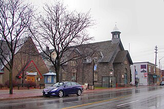
Westboro is an area in the west end of Ottawa, Ontario, Canada. Located along the Ottawa River, Island Park Drive defines Westboro's eastern border, while the Ottawa River defines its northern border. Under this definition, the population of the area is 22,725.
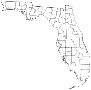
Boca Grande is a small residential community on Gasparilla Island in southwest Florida. Gasparilla Island is a part of both Charlotte and Lee counties, while the actual village of Boca Grande, which is home to many seasonal and some year-round residents, is entirely in the Lee County portion of the island. It is part of the Cape Coral-Fort Myers, Florida Metropolitan Statistical Area. Boca Grande is known for its historic downtown, sugar sand beaches, blue water and world class fishing.
The settlement of Steveston, founded in the 1880s, is a neighbourhood of Richmond in Metro Vancouver. On the southwest tip of Lulu Island, the village is a historic port and salmon canning centre at the mouth of the South Arm of the Fraser River. The early 1900s style architecture attracts both the film and tourism industries.

Fishtown is a neighborhood in the River Wards section of Philadelphia, Pennsylvania, United States. Located northeast of Center City Philadelphia, its borders are somewhat disputed today due to many factors, but are roughly defined by the triangle created by the Delaware River, Front Street, and York Street. Some newer residents expand the area to Lehigh Avenue to the northeast, while some older residents shrink the area to Norris Street. It is served by the Market–Frankford Line rapid transit subway/elevated line of the SEPTA system, and the historic Route 15 Girard Avenue trolley line. Fishtown has long been a largely working class Irish Catholic and Irish American neighborhood, though in recent years it has seen a large influx of young urban professionals and gentrification.

Celilo Village, Oregon is an unincorporated Native American community on the Columbia River in northeastern Wasco County in the U.S. state of Oregon. It is near Lake Celilo, the former site of Celilo Falls; it is just south of the community of Wishram, Washington, across the Columbia River.

Lulu Island is the name of the largest island in the estuary of the Fraser River, located south of Vancouver, British Columbia, Canada, and the second-most populous island in British Columbia, after Vancouver Island. The city of Richmond occupies most of the island, while a small section at the eastern tip, known as Queensborough, is part of the city of New Westminster.

Waswanipi is a Cree community in the Eeyou Istchee territory of central Quebec, Canada, located along Route 113 and near the confluence of the Chibougamau and Waswanipi Rivers. It has a population of 459 people. Waswanipi is a compound word composed of wâswân and -pî (lake), meaning "torch-fishing lake" but colloquially translated as "light over the water" referring to the traditional night-time fishing method of luring fish to light by using torches.
Zeballos is a village located on the northwest coast of Vancouver Island in British Columbia, Canada. Zeballos is now known for its ecotourism and sport fishing.
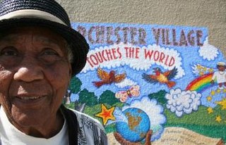
Parchester Village is a planned majority African-American village in northwestern Richmond, California that was the first in the state to sell to blacks.

Lower Lonsdale is a historic waterfront neighbourhood in the city of North Vancouver. Lower Lonsdale runs up Lonsdale Avenue from Lonsdale Quay to Keith Road. The area is characterized by its progressive feel of trendy businesses, a high end sex shop, outdoor fitness stores, eclectic cafes, and diverse restaurants. With a history of shipbuilding, in 2021 Lower Lonsdale underwent a major waterfront renewal process. The old shipyards have been torn down, making way for new public spaces, buildings, condominiums, and fashionable outlets.

The Gulf of Georgia Cannery is a National Historic Site of Canada located in Steveston village in Richmond, British Columbia.

The Wood River is a river in the U.S. states of Connecticut and Rhode Island. It flows approximately 25 miles (40 km) and is a major tributary of the Pawcatuck River. There are eight dams along the river's length.

Santa Clara is an unincorporated community in Lane County, Oregon and a neighborhood of Eugene. Prior to a number of partial annexations by the city between 1990 and 2005, Santa Clara was an unincorporated community and census-designated place in Lane County. Its current population is approximately 13,000.

Burkeville, British Columbia is a village located on Sea Island in Richmond, British Columbia, Canada.

Ambleside is a neighbourhood in West Vancouver that occupies the southeastern corner of the community, with only Park Royal being farther east. The neighborhood is bordered by the neighbourhoods of Dundarave, Park Royal, and the British Properties. Ambleside covers the area from 19th Street to 13th Street, and from Fulton Avenue down to the waterfront. Marine Drive forms the centre of the community's commercial core, with two streets leading off from it.
The Leq'á:mel First Nation, formerly known as Lakahahmen First Nation, is a First Nations band government whose community and offices are located in the area near Deroche, British Columbia in the Fraser Valley region in Canada, about 12 kilometres east of the District of Mission. They are a member government of the Sto:lo Nation Chiefs Council, which is one of two tribal councils of the Sto:lo.

Division No. 1, Subdivision G is an unorganized subdivision on the Avalon Peninsula in Newfoundland and Labrador, Canada. It is in Division 1 and contains the unincorporated communities of Baccalieu Island, Besom Cove, Bradley's Cove, Burnt Point, Caplin Cove, Daniel's Cove, Grates Cove, Gull Island, Job's Cove, Kingston, Long Beach, Lower Island Cove, Low Point, Northern Bay, Ochre Pit Cove, Red Head Cove, Riverhead, Smooth Cove and Western Bay.
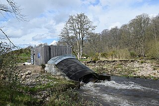
Aberdeen Community Energy operate a micro hydro scheme at Tillydrone on the River Don, Aberdeen.
