
In archaeology, a broch is an Iron Age drystone hollow-walled structure found in Scotland. Brochs belong to the classification "complex Atlantic roundhouse" devised by Scottish archaeologists in the 1980s.
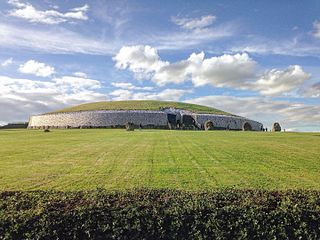
Newgrange is a prehistoric monument in County Meath in Ireland, located on a rise overlooking the River Boyne, eight kilometres west of the town of Drogheda. It is an exceptionally grand passage tomb built during the Neolithic Period, around 3200 BC, making it older than Stonehenge and the Egyptian pyramids. Newgrange is the main monument in the Brú na Bóinne complex, a World Heritage Site that also includes the passage tombs of Knowth and Dowth, as well as other henges, burial mounds and standing stones.
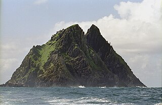
Skellig Michael, also called Great Skellig, is a twin-pinnacled crag 11.6 kilometres (7.2 mi) west of the Iveragh Peninsula in County Kerry, Ireland. The island is named after the archangel Michael, with "Skellig" derived from the Irish language word sceilig, meaning a splinter of stone. Its twin island, Little Skellig, is smaller and inaccessible. The two islands rose c. 374–360 million years ago during a period of mountain formation, along with the MacGillycuddy's Reeks mountain range. Later, they were separated from the mainland by rising water levels.
Rathcroghan is a complex of archaeological sites near Tulsk in County Roscommon, Ireland. It is identified as the site of Cruachan, the traditional capital of the Connachta, the prehistoric and early historic rulers of the western territory. The Rathcroghan Complex is a unique archaeological landscape with many references found in early Irish medieval manuscripts.

The Gallarus Oratory is a chapel on the Dingle Peninsula, County Kerry, Ireland. It has been presented variously as an early-Christian stone church by antiquary Charles Smith, in 1756; a 12th-century Romanesque church by archaeologist Peter Harbison in 1970; a shelter for pilgrims by the same in 1994. The local tradition prevalent at the time of Charles Smith attributed it to one Griffith More, being a funerary chapel built by him or his family at their burial place.

Souterrain is a name given by archaeologists to a type of underground structure associated mainly with the European Atlantic Iron Age.

The Bent Pyramid is an ancient Egyptian pyramid located at the royal necropolis of Dahshur, approximately 40 kilometres (25 mi) south of Cairo, built under the Old Kingdom Pharaoh Sneferu. A unique example of early pyramid development in Egypt, this was the second pyramid built by Sneferu.

The Stanton Drew stone circles are just outside the village of Stanton Drew in the English county of Somerset. The largest stone circle is the Great Circle, 113 metres (371 ft) in diameter and the second largest stone circle in Britain ; it is considered to be one of the largest Neolithic monuments to have been built. The date of construction is not known, but is thought to be between 3000 and 2000 BCE, which places it in the Late Neolithic to Early Bronze Age. It was made a scheduled monument in 1982.

Dowth is a Neolithic passage tomb near the River Boyne in County Meath, Ireland. It is one of the three main tombs of the Brú na Bóinne World Heritage Site, along with Newgrange and Knowth. Its features align it with the other passage tombs, which date from around 3200 BC. Unlike its bigger neighbours, Dowth has mostly been left as a ruin, although its smaller inner chambers are largely intact. The Royal Irish Academy carried out a botched excavation in 1847, leaving a large crater in the mound that has never been repaired.

Knowth is a prehistoric monument overlooking the River Boyne in County Meath, Ireland. It comprises a large passage tomb surrounded by 17 smaller tombs, built during the Neolithic era around 3200 BC. It contains the largest assemblage of megalithic art in Europe. Knowth is part of the Brú na Bóinne complex, a World Heritage Site that also includes the similar passage tombs of Newgrange and Dowth.

The pyramid of Khafre or of Chephren is the middle of the three Ancient Egyptian Pyramids of Giza, the second tallest and second largest of the group. It is the only pyramid out of the three that still has cladding at the top. It is the tomb of the Fourth-Dynasty pharaoh Khafre (Chefren), who ruled c. 2558−2532 BC.

The Grianan of Aileach, sometimes anglicised as Greenan Ely or Greenan Fort, is a hillfort atop the 244 metres (801 ft) high Greenan Mountain at Inishowen in County Donegal, Ireland. The main structure is a stone ringfort, thought to have been built by the Northern Uí Néill, in the sixth or seventh century CE; although there is evidence that the site had been in use before the fort was built. It has been identified as the seat of the Kingdom of Ailech and one of the royal sites of Gaelic Ireland. The wall is about 4.5 metres (15 ft) thick and 5 metres (16 ft) high. Inside it has three terraces, which are linked by steps, and two long passages within it. Originally, there would have been buildings inside the ringfort. Just outside it are the remains of a well and a tumulus.
Dromara is a village, townland and civil parish in County Down, Northern Ireland. It lies 10 kilometres (6.2 mi) to the southwest of Ballynahinch on the northern slopes of Slieve Croob, with the River Lagan flowing through it. It is situated in Dromara and the historic barony of Iveagh Lower, Lower Half. In the 2011 census it had a population of 1,006 people.

Belas Knap is a neolithic, chambered long barrow situated on Cleeve Hill, near Cheltenham and Winchcombe, in Gloucestershire, England.

Prehistoric Orkney refers only to the prehistory of the Orkney archipelago of Scotland that begins with human occupation. Although some records referring to Orkney survive that were written during the Roman invasions of Scotland, “prehistory” in northern Scotland is defined as lasting until the start of Scotland's Early Historic Period.

An erdstall is a type of tunnel found across Europe. They are of unknown origin but are believed to date from the Middle Ages. A variety of purposes have been theorized, including that they were used as escape routes or hiding places, but the most prominent theory is that they served a religious or spiritual purpose.

Tulach an t-Sionnaich, is a cairn at the northern end of Loch Calder in Caithness, Scotland that has been expanded over time. It was partially excavated in 1961 and 1963. Before the excavations there was just a 60-metre (200 ft) long and 12-metre (40 ft) wide cairn with no recognizable structures. The cairn is oriented from northwest to southeast; the southeastern end being higher and somewhat wider. Subsequently a ditch was cut some 15 metres (50 ft) from this end of the cairn.

Creevykeel Court Tomb is one of the finest examples of a court tomb remaining in Ireland. The monument is located in the N15 Donegal to Sligo road, 50 meters north of Creevykeel cross-roads close to Cliffoney village in County Sligo. The original name for the Creevykeel monument is Caiseal an Bhaoisgin, the Fort of Bhaoisgin, Tobar an Bhaoisgin being the name of the well near the cairn. A second megalithic monument existed 300 meters to the north, but it was demolished around 1890.

Donaghmore Souterrain is a souterrain and National Monument located in County Louth, Ireland.
Cashelmore, also called Clogher Stone Fort, is a stone ringfort (cashel) and National Monument located in County Sligo, Ireland.

