First Oil Well in Oklahoma

Last updated
First Oil Well in Oklahoma
USA Oklahoma location map.svg
Red pog.svg
Usa edcp location map.svg
Red pog.svg
Nearest city Wapanucka, Oklahoma
Coordinates 34°24′6″N96°22′25″W / 34.40167°N 96.37361°W / 34.40167; -96.37361 Coordinates: 34°24′6″N96°22′25″W / 34.40167°N 96.37361°W / 34.40167; -96.37361
Area5 acres (2.0 ha)
Built1888
NRHP reference No. 72001053 [1]
Added to NRHPApril 13, 1972

The First Oil Well in Oklahoma was drilled in 1885 in Atoka County, Choctaw Nation, Indian Territory, though it was not completed until 1888.

Contents

The First Oil Well in Oklahoma (also known as Old Faucett Well) is a historic oil well site near the present Wapanucka, Johnston County, Oklahoma. It was drilled by Dr. H.W. Faucett, who started work in 1885 on Choctaw land for the Choctaw Oil and Refining Company, but the 1,414-foot (431 m) well was not completed until 1888. A small amount of oil and gas was produced, but not in commercially usable quantity. The well was abandoned after Faucett fell ill and died later in 1888. [2] The first commercially productive well in Indian Territory was the Nellie Johnstone No. 1 well near Bartlesville, Oklahoma (then in the Cherokee Nation), drilled in 1897.

The well was added to the National Register of Historic Places (NRHP) in 1972. [1] The capped well casing is the well's only remnant. [2]

Background

The presence of oil in Indian Territory had been observed for many years, usually as natural seepage from the ground. Oklahoma Historian Muriel H. Wright described an incident in 1859, in which Lewis Ross, the brother of Cherokee Chief John Ross, attempted to drill a deep water well for the salt works he owned in the Cherokee Nation. Instead, the well hit an oil formation. She reported that production was estimated at ten barrels a day for nearly a year. Production stopped when gas pressure in the formation dropped too low to continue the flow. [3]

According to the NRHP submission, Dr. H. W. Faucett, a resident of New York, was one of the first businessmen to recognize the potential of oil as a fuel in Indian Territory. He wrote the following letter to Rev. Allen Wright, Governor of the Choctaw Nation in Indian Territory, dated December 12, 1883, proposing terms for exploiting this resource. [2]

... It would be impossible to interest capital in the work unless there was some agreement as to the extent of territory that could be had and the specified royalty; it would not do to wait until petroleum was found. You will please write me fully and explicitly as to what can be done in both the Choctaw and Chickasaw nations. Say if you think the exclusive privilege can be had, also the pipe line privilege for transporting oil. [2]

Allen Wright evidently approved the proposal in principle and passed it on to the tribal council. On October 23, 1883, the council approved creating the "... Choctaw Oil and Refining Company, for the purpose of finding petroleum or rock oil, and increasing the revenue of the Choctaw Nation." [2] [lower-alpha 1] The authorizations (basically concessions) gave exclusive rights for producing, transporting and refining in both nations ... an larea of nearly 20,000 square miles (52,000 km2). [2]

Muriel Wright reported that Dr. Eliphalet Nott Wright, [lower-alpha 2] then president of the Choctaw and Refining Company, enthusiastically backed Faucett. On several occasions when funds ran dangerously low, Dr. Wright supplied his own money to pay the workers and keep the well digging work going. This calmed the fears of other important Choctaws that Faucett was at fault for delaying completion of the well. [3]

Drilling operation

Faucett's crew erected a drilling rig on Choctaw land near Clear Boggy Creek in late 1885. The actual drilling operation was a very slow operation because all supplies had to be shipped by railroad from St. Louis to Atoka, then loaded onto oxcarts and driven 14 miles (23 km) to the job site. Poor lines of communications with Faucett's backers in the East slowed the delivery of funds, further hampering progress. [2] [3]

Construction of the Choctaw well apparently did not begin until after August 1885. By that time, members of both the Choctaw and Cherokee companies were complaining openly about the delays. Faucett explained to the Choctaw company that everything was ready to begin. However, the Cherokee operation, which had been approved a few months after the Choctaw agreements, would be started later. So, the Cherokee council repealed its 1884 act, effectively canceling their part of the project. On receiving this news, Faucett's New York backers, also backed out of the deal. That forced Faucett to find new financial backing in St. Louis. When Robert L. Owen [lower-alpha 3] tried to get the Cherokee council to reinstate the project in the following year, he found that both the Cherokees and the St. Louis backers had lost interest, so the Cherokee well was never resumed. [3]

End of the Choctaw project

The Choctaw project continued as promised, without unnecessary delays. Finally, the hole reached a depth of 1,414 feet (431 m), when the well started showing both oil and gas. [2] Faucett became ill at the jobsite just as work was being completed. He rushed to his home in Neosho, Missouri to seek medical treatment, but died shortly after. Evidently, all other parties to the project felt they could not continue without him, so the Choctaw Oil Company capped the well, abandoned the site and went out of business. [2] [3]

Notes

  1. Faucett had also contacted the Cherokee Nation with similar arrangement for drilling on its lands. The Cherokee Council approved his proposal on December 13, 1884. [2]
  2. Dr.E. N. Wright was the son of Rev. Allen Wright (and the uncle of Muriel Wright) [4]
  3. Robert L. Owen was an influential Cherokee, who became one of Oklahoma's first two U.S. Senators immediately after statehood in 1907.

Related Research Articles

Pushmataha County, Oklahoma U.S. county in Oklahoma

Pushmataha County is a county in the southeastern part of the U.S. state of Oklahoma. As of the 2010 census, the population was 11,572. Its county seat is Antlers.

Atoka County, Oklahoma U.S. county in Oklahoma

Atoka County is a county located in the U.S. state of Oklahoma. As of the 2010 census, the population was 14,007. Its county seat is Atoka. The county was formed before statehood from Choctaw Lands, and its name honors a Choctaw Chief named Atoka.

Atoka, Oklahoma City in Oklahoma, United States

Atoka is a city in, and the county seat of, Atoka County, Oklahoma, United States. The population was 3,107 at the 2010 census, an increase of 4.0 percent from the figure of 2,988 in 2000.

State of Sequoyah

The State of Sequoyah was a proposed state to be established from the Indian Territory in the eastern part of present-day Oklahoma. In 1905, with the end of tribal governments looming, Native Americans of the Five Civilized Tribes—the Cherokee, Choctaw, Chickasaw, Creek (Muscogee), and Seminole—in Indian Territory proposed to create a state as a means to retain control of their lands. Their intention was to have a state under Native American constitution and governance. The proposed state was to be named in honor of Sequoyah, the Cherokee who created a writing system in 1825 for the Cherokee language.

Choctaw Nation of Oklahoma Domestic dependent nation

The Choctaw Nation is a federally recognized Native American nation, with a reservation territory covering about 6,952,960 acres, occupying portions of southeastern Oklahoma in the United States. The Choctaw Nation is the third-largest federally recognized tribe in the United States and the second-largest Indian reservation in area after the Navajo. As of 2011, the tribe has 223,279 enrolled members, of whom 84,670 live within the state of Oklahoma and 41,616 live within the Choctaw Nation's jurisdiction. A total of 233,126 people live within these boundaries, with its tribal jurisdictional area compromising 10.5 counties in the state.

Boggy Depot, Oklahoma United States historic place

Boggy Depot is a ghost town and Oklahoma State Park that was formerly a significant city in the Indian Territory. It grew as a vibrant and thriving town in present-day Atoka County, Oklahoma, United States and became a major trading center on the Texas Road and the Butterfield Overland Mail route between Missouri and San Francisco. After the Civil War, when the MKT Railroad came through the area, it bypassed Boggy Depot and the town began a steady decline. It was soon replaced by Atoka as the chief city in the area. By the early 20th century, all that remained of the community was a sort of ghost town.

The Butterfield Overland Mail in Indian Territory was part of the overall Butterfield Overland Mail service (1857–1861) created by Congress March 3, 1857. The route crossed Indian Territory from Colbert's Ferry to Fort Smith, Arkansas which was the Center for the Overland Mail's' 7th Division. Fort Smith was also the junction point of the south bound coaches with the Memphis mail and its passengers. From Fort Smith the 7th Division route crossed the Poteau River into Indian Territory into the Choctaw Nation at Skullyville and left the Chickasaw Nation at Colbert's Ferry into Texas. There were 12 stage stations in Indian Territory, located from 13 to 19 miles (31 km) apart. The total length of the route across the territory was approximately 197 miles (317 km). The Butterfield route met with the Texas Road near Geary's Station and followed it southward to the Red River.

Fishers Station United States historic place

Fisher's Station, also known as Carriage Point, was a stage stand on the old Butterfield Overland Mail route and the Texas Road in Indian Territory. It was located at the head of Island Bayou in what is now Bryan County, Oklahoma. Island Bayou was then the dividing line between the Chickasaw and Choctaw Nations. From March 23, 1869, to February 6, 1871, the Carriage Point post office existed at the site and it is generally referred to by that name in the area. The Fishers were a well known Choctaw family.

Geary's Station was a stage stand on the old Butterfield Overland Mail route in Indian Territory. Sometimes called Geary's Crossing, it was located on the east side of LIttle Boggy Creek in what is now Atoka County, Oklahoma. It was operated by A.W. Geary, an inter-married Choctaw. His wife Lucy was the sister of a Choctaw chief. The Choctaw Nation had awarded Geary the privilege of building a bridge and tollgate at the Little Boggy crossing on the Fort Smith-Boggy Depot Road in 1858, which later became the route of the Butterfield Overland Mail stage.

Riddles Station United States historic place

Riddle's Station was a stage stand on the old Butterfield Overland Mail route in Indian Territory. It was located on the west side of the Forche Maline in what is now Latimer County. The station was named for Captain John Riddle, the operator. Riddle was a mixed-blood Choctaw and a prominent member of the Nation. He served many terms on the Choctaw Council. In 1858, the Council granted Riddle the right to build a bridge and tollbooth across the Forche Maline near his station.

Walkers Station United States historic place

Walker's Station was a stage stand on the old Butterfield Overland Mail route in Indian Territory. It was located at the old Choctaw Agency in Skullyville, in what is now Le Flore County, Oklahoma. The station was named for Tandy Walker, Choctaw chief, and later, Governor of the Choctaw Nation. The old Choctaw Agency building was his residence.

Chahta Tamaha, Indian Territory United States historic place

Chahta Tamaha was an important town in the Choctaw Nation, Indian Territory that served as the Choctaw capital from 1863 to 1883. The town grew up around the Armstrong Academy. The townsite is located in present-day Bryan County, Oklahoma. Today nothing is left of the town or the Academy. However, the Armstrong Academy Site is listed on the National Register of Historic Places.

Curtis Act of 1898

The Curtis Act of 1898 was an amendment to the United States Dawes Act; it resulted in the break-up of tribal governments and communal lands in Indian Territory of the Five Civilized Tribes of Indian Territory: the Choctaw, Chickasaw, Muscogee (Creek), Cherokee, and Seminole. These tribes had been previously exempt from the 1887 General Allotment Act because of the terms of their treaties. In total, the tribes immediately lost control of about 90 million acres of their communal lands; they lost more in subsequent years.

Allen Wright

Allen Wright was Principal Chief of the Choctaw Republic from late 1866 to 1870. He also became a Presbyterian minister after graduating from Union Theological Seminary in New York City. He was very active in the Choctaw government, holding several elected positions, and has been credited with the name Oklahoma for the land that would become the state.

Wallace Willis was a Choctaw freedman living in the Indian Territory, in what is now Choctaw County, near the city of Hugo, Oklahoma, US. His dates are unclear: perhaps 1820 to 1880. He is credited with composing several Negro spirituals. Willis received his name from his owner, Britt Willis, probably in Mississippi, the ancestral home of the Choctaws. He died, probably in what is now Atoka County, Oklahoma, as his unmarked grave is located there.

Treaty with Choctaws and Chickasaws

The Treaty with Choctaws and Chickasaws was a treaty signed on July 12, 1861 between the Choctaw and Chickasaw and the Confederate States of America. At the beginning of the American Civil War, Albert Pike was appointed as Confederate envoy to Native Americans. In this capacity he negotiated several treaties, one of the most important being with Cherokee chief John Ross, which was concluded in 1861. The treaty was ratified and was proclaimed on December 20, 1861 by the Confederacy. The Choctaw and Chickasaw also duly ratified the treaty.

Martin Luther Thompson was a Texas Choctaw leader and rancher who along with his relatives, William Clyde Thompson (1839–1912), Robert E. Lee Thompson (1872–1959) and John Thurston Thompson (1864–1907), led several families of Choctaws from the Mount Tabor Indian Community in Rusk County, Texas to Pickens County, Chickasaw Nation, I.T.

Muddy Boggy Creek, also known as the Muddy Boggy River, is a 175-mile-long (282 km) river in south central Oklahoma. The stream headwaters arise just east of Ada in Pontotoc County. It is a major tributary of the Red River in south central Oklahoma. Clear Boggy Creek is a major tributary which enters the Muddy Boggy at a location known as River Mile 24 in Choctaw County. The river is inhabited by over one hundred species of fish.

The Atoka Agreement is a document signed by representatives of the Choctaw and Chickasaw Indian Nations and members of the United States Dawes Commission on April 23, 1897, at Atoka, Indian Territory. It provided for the allotment of communal tribal lands of the Choctaw and Chickasaw nations in the Indian Territory to individual households of members of the tribes, who were certified as citizens of the tribes. Land in excess of the allotments could be sold to non-natives. Provisions of this agreement were later incorporated into the Curtis Act of 1898, which provided for widespread allotment of communal tribal lands.

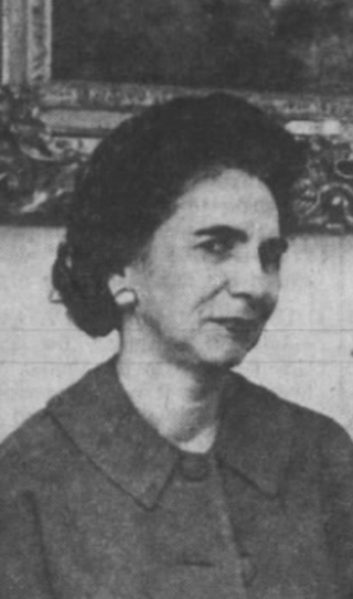
Muriel Hazel Wright was an American teacher, historian and writer on the Choctaw Nation. A native of Indian Territory, she was the daughter of mixed-blood Choctaw physician Eliphalet Wright and the granddaughter of the Choctaw chief Allen Wright. She wrote several books about Oklahoma and was unofficially called "Historian of Oklahoma". She also was very active in the Oklahoma Historical Society and served as editor of the Chronicles of Oklahoma from 1955 to 1971.

References

  1. 1 2 "National Register Information System". National Register of Historic Places . National Park Service. July 9, 2010.
  2. 1 2 3 4 5 6 7 8 9 Ruth, Kent (August 1971). "National Register of Historic Places Inventory - Nomination Form: First Oil Well in Oklahoma". National Park Service. Retrieved 9 May 2013.
  3. 1 2 3 4 5 Wright, Muriel H. "First Oklahoma Oil was Produced in 1859." Chronicles of Oklahoma. Vol. 4, No. 4. December, 1926. Accessed August 18, 2016.
  4. Wright, Muriel H. "A Brief Review of the Life of Doctor Eliphalet Nott Wright (1858-1932)." Chronicles of Oklahoma. Vol. 10, No. 2, June 1932.] Accessed August 19, 2016