Related Research Articles
Polk County is a county located in the northwestern part of the U.S. state of Georgia. As of the 2020 census, the population was 42,853. The county seat is Cedartown. The county was created on December 20, 1851, by an act of the Georgia General Assembly and named after James K. Polk, the eleventh President of the United States.

Jackson County is a county located in the northeastern part of the U.S. state of Georgia. As of the 2020 census, the population was 75,907. The county seat is Jefferson.
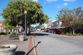
Rockmart is a town in Polk County, Georgia, United States. Its population was 4,732 at the 2020 census. It developed as a railroad depot town when the Southern Railway built a station in the area. The community was incorporated in 1872, and was named from abundant deposits of slate in the area. The Rockmart Downtown Historic District is listed on the National Register of Historic Places.

The Etowah River is a 164-mile-long (264 km) waterway that rises northwest of Dahlonega, Georgia, north of Atlanta. On Matthew Carey's 1795 map the river was labeled "High Town River". On later maps, such as the 1839 Cass County map, it was referred to as "Hightower River", a name that was used in most early Cherokee records.

Noonday Creek is a 20.2-mile-long (32.5 km) stream in Cobb and Cherokee counties in the U.S. state of Georgia. The stream begins near Kennesaw Mountain and ends at Lake Allatoona.
Gull Island is the name of a dozen small islands in the U.S. state of Michigan.
Cedar Creek is a stream in Floyd County and Polk County, Georgia.
Georgia Northwestern Technical College (GNTC) is a public technical college serving nine counties across northwestern Georgia. It operates under the Technical College System of Georgia. The college has six campuses: Catoosa County campus, Walker County Campus, Floyd County Campus, Gordon County Campus, Polk County Campus, and Whitfield-Murray Campus.
Etna is an unincorporated community in Polk County, in the U.S. state of Georgia.

The Seaborn Jones Memorial Park, formerly known as Wayside Park, was renamed in 2002 after Seaborn Jones because of his generosity and other significant contributions that he made to the city. The park sits in the middle of the Historical Downtown district of the City of Rockmart, Georgia along the banks of the Euharlee Creek. The name Euharlee comes from the Cherokee or Creek Indians and means "she laughs as she runs."
Clear Boggy Creek, also known as the Clear Boggy River, is a 132-mile-long (212 km) creek in southeastern Oklahoma that is a tributary of Muddy Boggy Creek.
Fish Creek is an unincorporated community in Polk County, Georgia, United States.
Georgia's 14th congressional district is a United States congressional district in Georgia. The district is represented by Republican Marjorie Taylor Greene. Located in Northwest Georgia, it was created following the 2010 census, when the state gained a 14th seat in the U.S. House of Representatives. With a Cook Partisan Voting Index of R+22, it is tied with the 9th district for the most Republican congressional district in Georgia.
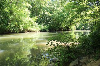
Euharlee Creek is a 21-mile-long (35 km) waterway which traverses across two counties in Georgia, USA, Bartow County and Polk County. It begins in Polk County near the city of Rockmart and joins the Etowah River in Euharlee. The historic Euharlee Covered Bridge spans Euharlee Creek.
Silver Creek is a stream in Floyd County and Polk County, Georgia, in the United States.
Antioch is an unincorporated community in Polk County, in the U.S. state of Georgia.
Portland is an unincorporated community in Polk County, in the U.S. state of Georgia.
Van Wert is an unincorporated community in Polk County, in the U.S. state of Georgia.
Oates is an unincorporated community in northern Reynolds County, in the U.S. state of Missouri. The community is located on Brushy Creek st the intersection of Missouri Route J and county road 836. Nearby communities include Black, approximately seven miles to the east-southeast on the Middle Fork of the Black River and Buick, about six miles to the northwest in Iron County.
Sheltonville or Shake Rag is an unincorporated community in Forsyth and Fulton counties, in the U.S. state of Georgia. Some of the community was formerly located in Milton County until the county was dissolved in 1931, during the Great Depression.
References
- ↑ U.S. Geological Survey Geographic Names Information System: Fish Creek (Georgia)
- ↑ "Polk County". Calhoun Times. 1 September 2004. p. 100. Retrieved 26 April 2015.
34°02′10″N85°03′23″W / 34.03611°N 85.05639°W