Related Research Articles

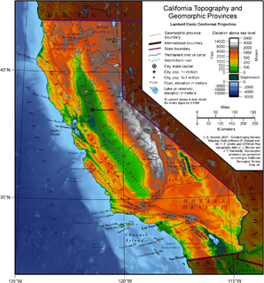
California is a U.S. state on the western coast of North America. Covering an area of 163,696 sq mi (423,970 km2), California is geographically diverse. The Sierra Nevada, the fertile farmlands of the Central Valley, and the arid Mojave Desert of the south are some of the major geographic features of this U.S. state. It is home to some of the world's most exceptional trees: the tallest, most massive, and oldest. It is also home to both the highest and lowest points in the 48 contiguous states. The state is generally divided into Northern and Southern California, although the boundary between the two is not well defined. San Francisco is decidedly a Northern California city and Los Angeles likewise a Southern California one, but areas in between do not often share their confidence in geographic identity. The US Geological Survey defines the geographic center of the state at a point near North Fork, California.

San Bernardino County, officially the County of San Bernardino, is a county located in the southern portion of the U.S. state of California, and is located within the Inland Empire area. As of the 2010 U.S. Census, the population was 2,035,210, making it the fifth-most populous county in California and the 14th-most populous in the United States. The county seat is San Bernardino.

Barstow is a city in San Bernardino County, California, United States. The population was 22,639 at the 2010 census. Barstow is located 67 miles (108 km) north of San Bernardino.

Victorville is a city located in the Victor Valley of southwestern San Bernardino County, California. Its population as of the 2010 census was 115,903.

The Mojave River is an intermittent river in the eastern San Bernardino Mountains and the Mojave Desert in San Bernardino County, California, United States. Most of its flow is underground, while its surface channels remain dry most of the time, with the exception of the headwaters and several bedrock gorges in the lower reaches.

The San Bernardino Mountains are a high and rugged mountain range in Southern California in the United States. Situated north and northeast of San Bernardino and spanning two California counties, the range tops out at 11,489 feet (3,502 m) at San Gorgonio Mountain – the tallest peak in all of Southern California. The San Bernardinos form a significant region of wilderness and are popular for hiking and skiing.

Bell's vireo is a small North American songbird. It is 4.75 to 5 in in length, dull olive-gray above and whitish below. It has a faint white eye ring and faint wing bars.

The San Bernardino Valley is a valley in Southern California. It lies at the south base of the Transverse Ranges. It is bordered on the north by the eastern San Gabriel Mountains and the San Bernardino Mountains; on the east by the San Jacinto Mountains; and on the south by the Temescal Mountains and Santa Ana Mountains; and on the west by the Pomona Valley. Elevation varies from 180 metres (590 ft) on valley floors near Chino, where it gradually increases to about 420 metres (1,380 ft) near San Bernardino and Redlands. The valley floor is home to over 80% of the more than 4 million people of the Inland Empire region.

Oro Grande is an unincorporated community in the Mojave Desert of San Bernardino County, California, United States. It lies on the city boundary of Victorville and Adelanto. It is at 3,000 feet (910 m) elevation in Victor Valley north of the San Bernardino mountain range. It is located on old Route 66 near Interstate 15 between Victorville and Barstow. The ZIP code is 92368 and the community is inside area codes 442 and 760. Less than 1,000 residents live in the unincorporated area.

Newberry Springs is an unincorporated community in the western Mojave Desert of Southern California, located at the foot of the Newberry Mountains in San Bernardino County, California, United States. The population at the 2000 census was 2,895.

Stater Bros. Markets is a privately held supermarket chain, based in San Bernardino, California, consisting of 200+ stores located throughout Southern California. It was founded in Yucaipa, California, on August 17, 1936, by twin brothers Cleo and Leo Stater when they purchased the market owned by Cleo's boss, W.A. Davis, with a $600 down payment. Cleo recalled to the Inland Empire Business Press in 1998 that the owner of the market across the street from Davis's gave him the other $300 to make the full down payment. Stater Bros. went public in 1964; Cleo, Leo, and their brother Lavoy sold their interests to the now-defunct Long Beach-based Petrolane Gas Service in 1968. The chain has been owned fully by Stater Bros. Holdings, a subsidiary of La Cadena Investments, owned by Stater's late chairman, president and CEO, Jack H. Brown, since 1986.

Silverwood Lake is a large reservoir in San Bernardino County, California, United States, located on the West Fork Mojave River, a tributary of the Mojave River in the San Bernardino Mountains. It was created in 1971 as part of the State Water Project by the construction of the Cedar Springs Dam as a forebay on the 444-mile (715 km) long California Aqueduct, and has a capacity of 73,000 acre feet (90,000,000 m3).

The Mojave Road, also known as Old Government Road, is a historic route and present day dirt road across what is now the Mojave National Preserve in the Mojave Desert in the United States. This rough road stretched 147 miles (237 km) from Beale's Crossing, to Fork of the Road location along the north bank of the Mojave River where the old Mojave Road split off from the route of the Old Spanish Trail/Mormon Road.

High Desert is an informal designation, with non-discreet boundaries, applied to areas of the Mojave Desert in Southern California that are generally between 2,000 feet (610 m) and 4,000 feet (1,200 m) in elevation, and located just north of the San Bernardino and Little San Bernardino Mountains.

Lake Manix is a former lake fed by the Mojave River in the Mojave Desert. It lies within San Bernardino County, California. Located close to Barstow, this lake had the shape of a cloverleaf and covered four basins named Coyote, Cady/Manix, Troy and Afton. It covered a surface area of 236 square kilometres (91 sq mi) and reached an altitude of 543 metres (1,781 ft) at highstands, although poorly recognizable shorelines have been found at altitudes of 547–558 metres (1,795–1,831 ft). The lake was fed by increased runoff during the Pleistocene and overflowed into the Lake Mojave basin and from there to Lake Manly in Death Valley, or less likely into the Bristol Lake basin and from there to the Colorado River.

The Genesis Solar Energy Project is a concentrated solar power station located in the Mojave Desert on 1,920 acres (780 ha) of Bureau of Land Management land, in eastern Riverside County, California. The plant is owned/managed by Genesis Solar, LLC, a subsidiary of NextEra Energy Resources, LLC. The Genesis Solar Energy Project is located about 25 miles (40 km) west of Blythe, in the Lower Colorado River Valley. The plant was built in the Colorado Desert along an ancient trade route that native people had traveled for thousands of years. The route traversed the Sonoran Desert and enabled trade between the Colorado River and the coast.

Camp Cady was a U.S. Army Camp, on the Mojave Road near the Mojave River in the Mojave Desert, located about 20 miles east of modern-day Barstow, California in San Bernardino County, at an elevation of 1690 feet. Camp Cady was named after Major Albemarle Cady, 6th Infantry Regiment, who was a friend of Carleton and commander at Fort Yuma in 1860.

Monument Peak is a summit in the San Bernardino Mountains, of San Bernardino County, California. It lies at an elevation of 5272 feet.

Castle Mountains National Monument is a U.S. National Monument located in the eastern Mojave Desert and northeastern San Bernardino County, in the state of California.

Sand to Snow National Monument is a U.S. National Monument located in San Bernardino County and into northern Riverside County, Southern California.
References
- ↑ California. Legislature (1891). Journal: Appendix. Reports. 4. p. 218. Retrieved 2015-12-02.
- ↑ Brown, J.; Boyd, J. (1922). History of San Bernardino and Riverside Counties: With Selected Biography of Actors and Witnesses of the Period of Growth and Achievement... Western Historical Association. p. 105 . Retrieved 2015-12-02.
| This San Bernardino County, California–related article is a stub. You can help Wikipedia by expanding it. |