
Farm Island Township is a township in Aitkin County, Minnesota, United States. The population was 1,099 as of the 2010 census.
Mud Lake is an unorganized territory located in Marshall County, Minnesota, United States. In both the 2000 and 2010 U.S. censuses, the unorganized territory recorded a population of 0.
Brimson is an unincorporated community in Ault Township, Saint Louis County, Minnesota, United States.

The Pigeon River forms part of the Canada–United States border between the state of Minnesota and the province of Ontario, west of Lake Superior. In pre-industrial times the river was a waterway of great importance for transportation and the fur trade.

Eagle Mountain is the highest natural point in Minnesota, United States, at 2,301 feet (701 m). It is in northern Cook County in the Boundary Waters Canoe Area Wilderness and Superior National Forest in the Misquah Hills, northwest of Grand Marais. It is a Minnesota State Historic Site.

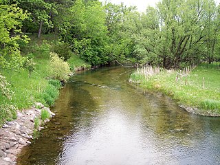
The Chippewa River is a 153-mile-long (246 km) tributary of the Minnesota River in western and southwestern Minnesota in the United States. Via the Minnesota River, it is part of the watershed of the Mississippi River.
Saginaw is an unincorporated area in Saint Louis County, Minnesota, United States. Although unincorporated, Saginaw has a post office with the ZIP code 55779.
Fairbanks is an unincorporated community in Fairbanks Township, Saint Louis County, Minnesota, United States; located within the Superior National Forest.
Central Lakes is an unincorporated community in Saint Louis County, Minnesota, United States.
The Fish Hook River, also spelled Fishhook River, is a tributary of the Shell River, 9 miles (14 km) long, in north-central Minnesota in the United States. The river's source, Fish Hook Lake, collects short tributaries known as the Portage River and the Potato River. Via the Shell and Crow Wing rivers, the Fish Hook River is part of the watershed of the Mississippi River. The river flows for its entire length in southwestern Hubbard County; its watershed extends into northeastern Becker County.
A fishhook is a device for catching fish. Fishhook or fish hook may also refer to:

The Caribou River is a 15.0-mile-long (24.1 km) river in northern Minnesota, the United States. It rises in a swamp about .6 miles (1 km) south of Morris Lake and two miles (3.2 km) east of Echo Lake, near the Lake/Cook County line, at an altitude about 1620 feet above sea level. It descends some 1,020 feet in elevation as it flows south to its mouth at Lake Superior, also near the eastern border of Lake County.
Okabena Creek is a 40-mile-long (64 km) waterway in southern Minnesota. It is a tributary, via the short Diversion Creek, of Heron Lake, the outlet of which flows to the Des Moines River. Okabena Creek begins in Worthington, Minnesota, connecting by a ditch to the outlet of Okabena Lake, then flows northeast past the towns of Brewster and Okabena to the Heron Lake/South Heron Lake system.
The Flatvaer Islands, also known as the Ongul Islands, are a group of small islands lying at the east side of the entrance of Lützow-Holm Bay, 4 km from the coastline of Antarctica. They were mapped by Norwegian cartographers from air photos taken by the Lars Christensen Expedition (LCE), 1936–37. Many of the islands and their features were subsequently named by members of the Japanese Antarctic Research Expedition (JARE); unless otherwise noted, features noted in this article were named by JARE.
Nett Lake is an unincorporated community and census-designated place (CDP) in Nett Lake Territory, Saint Louis County, Minnesota, United States; located on the shore of Nett Lake. As of the 2010 census, its population was 284.
Island Lake is an unincorporated community in Beltrami County, in the U.S. state of Minnesota.
Fox Lake is an unincorporated community in Martin County, in the U.S. state of Minnesota.
Wall Lake is an unincorporated community in Otter Tail County, in the U.S. state of Minnesota.

