
The Gulf of Saint Lawrence is the outlet of the North American Great Lakes via the Saint Lawrence River into the Atlantic Ocean. The gulf is a semi-enclosed sea, covering an area of about 226,000 square kilometres (87,000 sq mi) and containing about 34,500 cubic kilometres (8,300 cu mi) of water, which results in an average depth of 152 metres (499 ft).
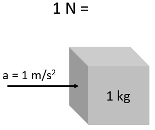
The newton is the International System of Units (SI) derived unit of force. It is named after Isaac Newton in recognition of his work on classical mechanics, specifically Newton's second law of motion.
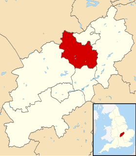
Kettering is a local government district and borough in Northamptonshire, England. It is named after its main town Kettering where the council is based. It borders onto the district of Harborough in the neighbouring county of Leicestershire, the borough of Corby, the district of East Northamptonshire, the district of Daventry and the borough of Wellingborough.

The Isaac Newton Institute for Mathematical Sciences is an international research institute for mathematics and its many applications at the University of Cambridge. It is named after one of the university's most illustrious figures, the mathematician and natural philosopher Sir Isaac Newton and occupies buildings adjacent to the Cambridge Centre for Mathematical Sciences.
Bradbury is a village in County Durham, England. It is situated between Sedgefield and Newton Aycliffe, close to the A1(M) and A689, and is approximately 16 km (9.9 mi) from Middlesbrough. Bradbury is a small agricultural village. The moorland around it is of glacial origin.
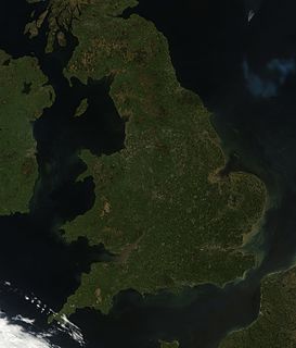
England comprises most of the central and southern two-thirds of the island of Great Britain, in addition to a number of small islands of which the largest is the Isle of Wight. England is bordered to the north by Scotland and to the west by Wales. It is closer to continental Europe than any other part of mainland Britain, divided from France only by a 33 km (21 mi) sea gap, the English Channel. The 50 km (31 mi) Channel Tunnel, near Folkestone, directly links England to mainland Europe. The English/French border is halfway along the tunnel.
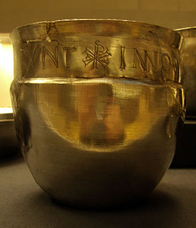
Durobrivae was a Roman fortified garrison town located at Water Newton in the English county of Cambridgeshire, where Ermine Street crossed the River Nene. More generally, it was in the territory of the Corieltauvi in a region of villas and commercial potteries. The name is a Latinisation of Celtic *Durobrīwās, meaning essentially "fort bridges".
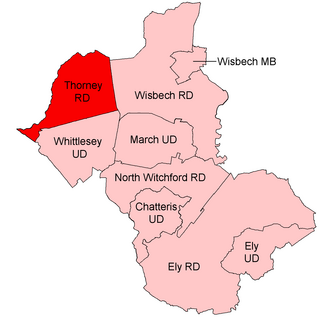
Thorney was a rural district in England from 1894 to 1974, situated to the east of Peterborough.

Newton's Cove is a small cove with sand, shingle and rock pools, 0.5 kilometres (0.3 mi) south of Weymouth, Dorset, England, overlooking Portland Harbour and next to the Nothe Fort. The beach is mainly used by locals and by tourists who visit the Nothe Gardens and the fort.
Newton Abbot Racecourse is a thoroughbred horse racing venue located on the north bank of the River Teign in the parishes of Kingsteignton and Teigngrace just north of Newton Abbot, Devon, England. The course is a tight, flat left-handed oval of about 1 mile 1 furlong. There are seven relatively easy fences to a circuit and a very short run in to the finish.
Wryde railway station was a station serving Wryde, Cambridgeshire on the Midland and Great Northern Joint Railway between Wisbech and Peterborough. Originally built by the Peterborough, Wisbech and Sutton Bridge Railway, it was opened for goods traffic on 1 June 1866 and for passengers on 1 August of the same year.

Little Bytham railway station was a station in Little Bytham, Lincolnshire on the Great Northern Railway main line. It closed in 1959. The Midland and Great Northern Joint Railway crossed just north of the station. The GNR were given powers to build a junction but never did so. The nearest station on the M&GNR was at Castle Bytham.
Redmile railway station served the villages of Redmile and Barkestone-le-Vale, Nottinghamshire and also Belvoir Castle. It was on the Great Northern and London and North Western Joint Railway. It opened in 1879 and closed to passengers in 1951.

Newton Road railway station was a station of the London and North Western Railway in Sandwell between West Bromwich and Great Barr, England. It lay between Hamstead and the later Tame Bridge Parkway stations on what is now known as the Chase Line.

The Herb River is an 8.0-mile-long (12.9 km) tidal river in the U.S. state of Georgia. It is located in Chatham County, near the southeastern edge of Savannah. It connects with the Wilmington River to the north and the Moon River to the south, and it separates the mainland on the west from Isle of Hope and Dutch Island to the east.

Newton and Haceby is a civil parish in North Kesteven, Lincolnshire, England. It includes the separate hamlets of Newton and Haceby. The population of the civil parish at the 2011 census was 137.

SS or RMS The Ramsey was a passenger steamer operated by the Isle of Man Steam Packet Company from 1912 to 1914. She had been built in 1895 as Duke of Lancaster for the joint service to Belfast of the London and North Western Railway and Lancashire and Yorkshire Railway companies. The steamer was requisitioned by the Admiralty in 1914 as the armed boarding vessel HMS Ramsey and sunk the following year.
Darlington is an unincorporated community in Muskingum County, in the U.S. state of Ohio.

Newton Burgoland Marshes is an 8.7 hectare biological Site of Special Scientific Interest east of Newton Burgoland in Leicestershire.


