
La Tuque is a city located in north-central Quebec, Canada, on the Saint-Maurice River, between Trois-Rivières and Chambord. The population was 11,129 at the 2021 Canadian census, most of which live within the urban area. At over 28,000 km2 (11,000 sq mi), it is the largest city in Canada by area.
The Batiscan Lake is located in Upper Batiscanie and is the limit of unorganized territories of Lac-Blanc and Lac-Croche. This territory is related to the La Jacques-Cartier Regional County Municipality, in the administrative region of the Capitale-Nationale, in the province of Quebec, Canada.
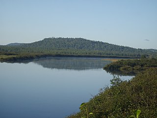
The Manouane River flows from west to east in the Haute-Mauricie (Upper-Mauricie), at northwest of La Tuque, in the administrative region of Lanaudière and Mauricie, in the Province of Quebec, Canada. The river basin is mostly covered by forest.
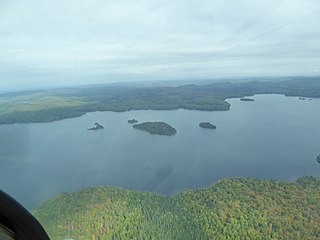
The Wayagamac Lake is located in the city of La Tuque in La Tuque, in Mauricie, in Quebec, in Canada. Until 2006, the territory of the lake was part of the former unorganized territory of Petit-Lac-Wayagamac, before being merged to the La Tuque. The area of the lake is administered by the Zec de la Bessonne.
The river Bostonais or Bostonians is a river of Canada, located in Quebec, in the administrative region of Mauricie, in La Tuque.
The Wessonneau River flows north-east in the Mekinac Regional County Municipality in Mauricie, in Quebec, in Canada, on the west bank of the Saint-Maurice River. The watershed of the river is administered by:
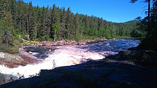
The Trenche River flows in a southwesterly direction through two forested areas. The first is the unorganized territory of Lac-Ashuapmushuan, in the MRC Le Domaine-du-Roy Regional County Municipality, administrative region of Saguenay-Lac-Saint-Jean. Secondly, within La Tuque, Upper Mauricie, Quebec, Canada. This river is one of the five most important tributaries of the Saint-Maurice River.

The Vermillon River flows in the territory of La Tuque, in Upper-Mauricie, in the administrative region of Mauricie, in Quebec, Canada.
The lac Ventadour is the main headwater lake of the Bostonnais River. This lake is located in the La Tuque, in Mauricie, in Quebec, in Canada. The area around the lake is mostly administered by the Zec Kiskissink.
The ZEC de la Croche is a "zone d'exploitation controlée" (ZEC) in La Tuque, in administrative region of Mauricie, in Québec, in Canada. This public hunting and fishing area is located 18 km north of La Tuque and offers the public an area of 351.8 square kilometres (135.8 sq mi). The zec is managed by the "Sacerf La Croche Association".
The Zec Kiskissink is a "zone d'exploitation contrôlée" (zec), located in the administrative region of the Mauricie, the Capitale-Nationale and Saguenay-Lac-Saint-Jean, in Quebec, in Canada. This wild territory, used for recreative activities is managed by the "Sacerf Macousine Association".
The ZEC Wessonneau is a "zone d'exploitation contrôlée" (ZEC), located on the west bank of the Saint-Maurice River, in the La Tuque, in the region the Mauricie, in Quebec (Canada). This public hunting and fishing area is managed by the "Association chasse et pêche Fléchée Inc".
The ZEC du Gros-Brochet is a "zone d'exploitation contrôlée" (ZEC), located in the region of Mauricie, in Quebec, in Canada. This public hunting and fishing area is managed by the "Association Sportive du Gros-Brochet Inc".
The ZEC Frémont is a "zone d'exploitation contrôlée" (ZEC) located in administrative region of Mauricie, in Quebec, in Canada. This public hunting and fishing area is managed by the "Association de chasse et pêche Frémont". Zec Frémont was established in 1978 as part of the abolition of private clubs by the Government of Québec.
The Zec Batiscan-Neilson is a "zone d'exploitation contrôlée", located in the unorganized territory of Lac-Blanc, in Portneuf Regional County Municipality, in the administrative area of the Capitale-Nationale, on the north shore of St. Lawrence River, in Quebec, Canada.
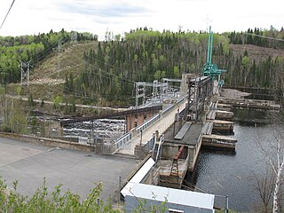
The Réservoir Blanc is a reservoir located in the city of La Tuque, in Quebec, Canada. The artificial lake was created in 1930 by the construction of the Rapide-Blanc Generating Station on Saint-Maurice River. The year 1996 marked the end of a period of 150 years of “drave” on the Saint-Maurice River; consequently the amateurs of recreation-touristic activities have appropriated the "Réservoir Blanc" mainly for boating and fishing. Around the reservoir and tributaries, a few hundred cottages are there and a few outfitters provide services to visitors.
The Lake Mondonac is located in Zec Fremont, in Matawinie, near the boundary of the region Lanaudière and Mauricie, in Quebec, in Canada.
Sincennes Township is located in the unorganized territory of Lac-Normand, in Mekinac Regional County Municipality, in Mauricie, in the province of Quebec, in Canada. This uninhabited township was incorporated on December 18, 1965 by the Government of Quebec. Sincennes Township has forestry and tourism including hunting, fishing, water sports, ATVs, snowmobiles. Historically, logging was the economic engine of the region.
The Windigo River runs in the unorganized territory of Lac-Ashuapmushuan, Quebec and in the territory of La Tuque, in Mauricie, in Quebec, in Canada.
The Doucet River is a tributary of the southern shore of Lac au Lard, in the hydrographic slope of the Jeannotte River, in the territory of the town of La Tuque, in the administrative region of Mauricie, in Quebec, in Canada. This river flows in the zec de la Bessonne.
