
The Arctic Archipelago, also known as the Canadian Arctic Archipelago, is an archipelago lying to the north of the Canadian continental mainland, excluding Greenland.

Faughan Hill is a low hill approximately five miles to the northwest of Navan, County Meath, Ireland. It is owned by the Moriarty, McCabe, Dunne, English families, and is not open to the public. The highest point is owned by the Moriarty family.

Eastport is a long-popular Newfoundland vacation destination on the Eastport Peninsula. Eastport is located on the north-eastern border of Terra Nova National Park and is known for its sandy beaches, scenery and traditional Newfoundland outport heritage.

Grenadines is an administrative parish of Saint Vincent and the Grenadines, comprising the islands of the Grenadines other than those belonging to Grenada. The capital is Port Elizabeth.

Viesca is a town and seat of the surrounding municipality of the same name, located in the northern Mexican state of Coahuila. At the last census, Viesca had a population of 19,328. Of this number 9,695 were men and 9,633 were women.

Villarrín de Campos is a municipality located in the province of Zamora, Castile and León, Spain. According to the 2004 census (INE), the municipality has a population of 583 inhabitants.

Minna-jima (水納島) is an island within the Okinawa Islands, administered by Motobu, Kunigami District, Okinawa Prefecture, Japan.

Stary Pilczyn is a village in the administrative district of Gmina Łaskarzew, within Garwolin County, Masovian Voivodeship, in east-central Poland. It lies approximately 4 kilometres (2 mi) east of Łaskarzew, 12 km (7 mi) south of Garwolin, and 64 km (40 mi) south-east of Warsaw.
Horavenc is a village in the municipality of Baliton in the Lankaran Rayon of Azerbaijan.
Vana-Nurtu is a village in Märjamaa Parish, Rapla County in western Estonia.

Cvetke is a village in the municipality of Kraljevo, western-central Serbia. According to the 2002 census, the village has a population of 1070 people.
Atilissuaq Island is an island of Greenland. It is located in Baffin Bay in the Upernavik Archipelago.
Otlet Glacier is a glacier 9 nautical miles (17 km) long, flowing along the south side of Fontaine Heights to the west coast of Graham Land. Roughly charted by the British Graham Land Expedition (BGLE) under Rymill, 1934–37. More accurately mapped by the Falkland Islands Dependencies Survey (FIDS) from photos taken by Hunting Aerosurveys Ltd. in 1956–57. Named by the United Kingdom Antarctic Place-Names Committee (UK-APC) for Paul Otlet (1868–1944), Belgian documentalist, co-founder of the Institut International de Bibliographie at Brussels, 1895, and of the Universal Decimal Classification. He was a pioneer of the rational organization of polar information by an international classification scheme.

The Marshall Archipelago is an extensive group of large ice-covered islands within the Sulzberger Ice Shelf off Antarctica. Several of the islands were discovered and plotted by the Byrd Antarctic Expeditions and by the United States Antarctic Service (1939–41), all led by Admiral Richard E. Byrd. The full extent of the archipelago was mapped by the United States Geological Survey from surveys and U.S. Navy air photos (1959–65). The name was proposed by Admiral Byrd for General of the Army George C. Marshall, who made financial contributions as a private individual and also, on the same basis, provided advisory assistance to the Byrd expedition of 1933–35.
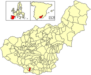
Ítrabo is a municipality in the province of Granada, Spain. As of 2010, it has a population of 1152 inhabitants.

Otroci is a village in the municipality of Vrnjačka Banja, Serbia. According to the 2011 census, the village has a population of 498 people.

Dallas Reef, also known as Malay: Terumbu Laya; Vietnamese: đá Suối Cát; Mandarin Chinese: 光星礁; pinyin: Guāngxīng Jiāo; Rajah Matanda Reef, lies on the SW extremity of Dangerous Ground in the Spratly Islands of the South China Sea.
This page is based on this
Wikipedia article Text is available under the
CC BY-SA 4.0 license; additional terms may apply.
Images, videos and audio are available under their respective licenses.
