The Southern Alps are a mountain range extending along much of the length of New Zealand's South Island, reaching its greatest elevations near the range's western side. The name "Southern Alps" generally refers to the entire range, although separate names are given to many of the smaller ranges that form part of it.

Marlborough District or the Marlborough Region, commonly known simply as Marlborough, is one of the 16 regions of New Zealand, located on the northeast of the South Island. Marlborough is a unitary authority, both a district and a region. Marlborough District Council is based at Blenheim, the largest town. The unitary region has a population of 52,200.

The Waikato River is the longest river in New Zealand, running for 425 kilometres (264 mi) through the North Island. It rises on the eastern slopes of Mount Ruapehu, joining the Tongariro River system and flowing through Lake Taupō, New Zealand's largest lake. It then drains Taupō at the lake's northeastern edge, creates the Huka Falls, and flows northwest through the Waikato Plains. It empties into the Tasman Sea south of Auckland, at Port Waikato. It gives its name to the Waikato region that surrounds the Waikato Plains. The present course of the river was largely formed about 17,000 years ago. Contributing factors were climate warming, forest being reestablished in the river headwaters and the deepening, rather than widening, of the existing river channel. The channel was gradually eroded as far up river as Piarere, leaving the old Hinuera channel through the Hinuera Gap high and dry. The remains of the old course are seen clearly at Hinuera, where the cliffs mark the ancient river edges. The Waikato's main tributary is the Waipā River, which converges with it at Ngāruawāhia.
The Inangahua River is located in the north-west of New Zealand’s South Island. It is a major tributary of the Buller River, where it joins at the town of Inangahua Junction.

Seddon is a small town in Marlborough, New Zealand. It is located 25 kilometres (16 mi) south of Blenheim, close to the mouths of the Awatere and Blind Rivers and the Lake Grassmere salt works.

Ward is a small town in Marlborough, New Zealand. It is located on State Highway 1, 82 kilometres (51 mi) north of Kaikōura. The Flaxbourne River flows past to the north and into the Pacific Ocean at Ward Beach to the south-east of Ward. A current initiative aims to have the town renamed as Flaxbourne.
Kenepuru Sound is one of the larger of the Marlborough Sounds in the South Island of New Zealand. The drowned valley is an arm of Pelorus Sound / Te Hoiere, it runs for 25 kilometres (16 mi) from the northeast to southwest, joining Pelorus Sound a quarter of the way down the latter's path to the Cook Strait.

The Conway River is part of the traditional boundary between the Canterbury and Marlborough regions in the South Island of New Zealand.

Long Island is located in Queen Charlotte Sound, one of the Marlborough Sounds of New Zealand. James Cook recorded its original name as Hamote.
Tuamarina River is a river in Marlborough in the South Island of New Zealand. It flows into the Wairau River just south of Tuamarina.

Waikawa is a small settlement to the north east of Picton, Marlborough, New Zealand. Waikawa Bay opens onto Queen Charlotte Sound.
The Fairhall River is a river in the Marlborough region of New Zealand. It arises near Blairich Pass and flows north-east to join the Ōpaoa River between Renwick and Blenheim. The locality of Fairhall is east of the river. The river and locality were named in 1847 for a chainman in a survey team in the area.
The Goulter River is a river in the Marlborough region of New Zealand. It rises in the Richmond Range near Lake Chalice. The lake was formed by a landslip about 2000 years ago, which dammed the river. The lake has no outlet, but water seeps through the landslip rubble into the Goulter. The river flows counter-clockwise around Mount Patriarch to join the Wairau River.
The Graham River is a river in the Marlborough Region of New Zealand. It arises to the south-east of Mount McCormick and flows north, then west, then north again, and into Whatamangō Bay on the south side of Queen Charlotte Sound.
The Guide River is a river in the Marlborough Region of New Zealand. It starts near Barefell Pass on the eastern side of the Rachel Range and flows south-east to join the Acheron River, which joins the Waiau Toa / Clarence River and eventually drains into the Pacific Ocean.
The Hakaru River is a river in the Northland Region of New Zealand. It starts in the Brynderwyn Hills and flows south to join the Topuni River exiting in the Oruawharo River, which forms part of the Kaipara Harbour.
The Eyre River is a river in the Canterbury region of New Zealand. It arises in the Puketeraki Range and flows south-east into the Waimakariri River near Christchurch International Airport. The connection with the Waimakariri is via a diversion channel running south-west, replacing the Eyre's original easterly flow. The river is named after Edward John Eyre, the Lieutenant-Governor of New Munster from 1848 to 1853.
The Gelt River is a river in the Canterbury region of New Zealand. It arises near Mount Peter in the Black Hills and flows south, then east and north-east into Conway River.

The Bryant Range is a range of low mountains in the northern South Island of New Zealand. They form part of the boundary of the Nelson and Tasman Districts with Marlborough Region, as well as forming the western boundary of Mount Richmond Forest Park The range is traversed by State Highway 6 at the Rai Saddle close to its northern end.

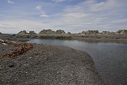
Ward Beach is a section of rugged coastline in the Marlborough Region of New Zealand that is known for unusual rock formations. The geological features include the exposed reef platforms that were uplifted by 2 m or more during the 2016 Kaikōura earthquake, and the spherical concretions known as the Ward Beach boulders. Another formation known as the Chancet Rocks is located in a scientific reserve about 1.5 km to the north of the Ward Beach roadend. They contain unusual trace fossils and provide amongst the best on-land evidence of the Cretaceous–Paleogene boundary in marine sediments in the Southern Hemisphere.