Related Research Articles

Greater Victoria is located in British Columbia, Canada, on the southern tip of Vancouver Island. It is usually defined as the thirteen municipalities of the Capital Regional District (CRD) on Vancouver Island as well as some adjacent areas and nearby islands.

A breakwater is a permanent structure constructed at a coastal area to protect against tides, currents, waves, and storm surges. Part of a coastal management system, breakwaters are installed to minimize erosion, and to protect anchorages, helping isolate vessels within them from marine hazards such as prop washes and wind-driven waves. A breakwater, also known in some contexts as a jetty, may be connected to land or freestanding, and may contain a walkway or road for vehicle access.

Montague Harbour Marine Provincial Park is a provincial park in British Columbia, Canada, located on Galiano Island, one of the Gulf Islands off BC's South Coast in Canada. It is accessible by BC Ferries from Swartz Bay on Vancouver Island or Tsawwassen on the Mainland. The Island's ferry terminal is at Sturdies Bay, about 6 km (3.7 mi) from Montague.
Sowchea Bay Provincial Park is a provincial park in central British Columbia, Canada. It is on Stuart Lake, west of Prince George. The park is 13 hectares in area. It is a busy destination for boaters and anglers, with a single-lane concrete boat launch available with limited parking.
Royal Roads is a roadstead or anchorage located in Strait of Juan de Fuca near the entrance to Esquimalt Harbour in Greater Victoria, British Columbia, Canada.
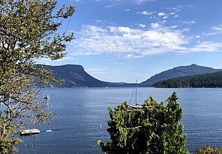
Maple Bay is a seaside community located in the Cowichan Valley of southern Vancouver Island, British Columbia, Canada. A narrow inlet and surrounded by smooth, pebbled beaches, Maple Bay is home to marine activity all year round. Maple Bay is a small town with a population of 2,640.
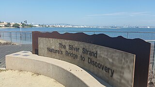
Silver Strand, or simply The Strand, is a low, narrow, sandy isthmus or tombolo 7 miles (11 km) long in San Diego County, California partially within the Silver Strand State Beach. It connects Coronado Island with Imperial Beach. Together with the Point Loma peninsula it shelters and defines San Diego Bay. State Route 75 (SR 75) runs the length of the strand and is a popular site for jogging and bicycling. The Silver Strand Half Marathon is run along the route each November.

Fort Rodd Hill National Historic Site is a 19th-century coastal artillery fort on the Colwood side of Esquimalt Harbour,. The site is adjacent to Fisgard Lighthouse National Historic Site, the first lighthouse on the west coast of Canada. Both the fort and lighthouse are managed and presented to the public by Parks Canada.

Thetis Lake is a name that refers to two freshwater lakes connected by a narrow culvert in the 834-hectare (2,060-acre) Thetis Lake Regional Park outside Victoria, British Columbia, about 12 km (7.5 mi) from the city centre. It was established as Canada's first nature sanctuary in 1958. The park was named for the frigate HMS Thetis, which had been assigned to Esquimalt as part of the Royal Navy's Pacific Squadron. Thetis is encountered in Greek mythology mostly as a sea nymph or known as the goddess of water, one of the fifty Nereids, daughters of the ancient sea god Nereus. The park's facilities include several beaches, kilometres of forest trails, parking, washrooms and a change room. The two lakes are extremely popular in the summer. The area features many Garry oak and Douglas fir trees.

Victoria Harbour is a harbour, seaport, and seaplane airport in the Canadian city of Victoria, British Columbia. It serves as a cruise ship and ferry destination for tourists and visitors to the city and Vancouver Island. It is both a port of entry and an airport of entry for general aviation. Historically it was a shipbuilding and commercial fishing centre. While the Inner Harbour is fully within the City of Victoria, separating the city's downtown on its east side from the Victoria West neighbourhood, the Upper Harbour serves as the boundary between the City of Victoria and the district municipality of Esquimalt. The inner reaches are also bordered by the district of Saanich and the town of View Royal. Victoria is a federal "public harbour" as defined by Transport Canada. Several port facilities in the harbour are overseen and developed by the Greater Victoria Harbour Authority, however the harbour master's position is with Transport Canada.

Ogden Point is a deep water port facility located in the southwestern corner of the city of Victoria, British Columbia, Canada. Its advantageous geographic location on the southern tip of Vancouver Island, by the Strait of Juan de Fuca, close to major population centres Vancouver and Seattle, has made it an attractive cruise ship destination. It also serves as a ship repair and supply facility for cruise ships and other vessels such as deep sea cable laying ships. Ogden Point also has a heliport with frequent service to Vancouver Harbour, Vancouver International Airport, and Seattle. The port lies at the eastern entrance of Victoria Harbour. For smaller boats there is boat ramp for trailerable boats.
Ten Mile Point is a neighbourhood in the District of Saanich in Victoria, British Columbia, and is the most easterly point on Vancouver Island. Ten Mile Point was so named because it was ten nautical miles from what was at the time the headquarters of the Pacific Station of the Royal Navy. Ten Mile Point is a wooded peninsula that forms one side of Cadboro Bay, the home of the Royal Victoria Yacht Club and the mythical Cadborosaurus sea monster. Cadboro Point is located on the east part of this peninsula. Prevost Hill was named after James Charles Prevost, British commissioner in the negotiations to settle the San Juan boundary dispute. Prevost Hill is the highest elevation on Ten Mile Point and is known informally in the neighbourhood as "Minnie Mountain". Prevost Hill is the location for a subdivision within Ten Mile Point called "Wedgewood Point" or "Wedgewood Estates". A small wooded island, "Flower Island", almost touches the southern shore of Ten Mile Point. Ten Mile Point has many secluded beaches and coves.

Point San Pablo Harbor is a marina and small community at the far end of Point San Pablo in San Pablo Bay, within Richmond, in Contra Costa County, California. It is located at 1900 Stenmark Drive, Richmond CA 94801.

Freshwater Bay is a bay upon the Strait of Juan de Fuca on the northern coast of the Olympic Peninsula, 10 miles (16 km) west of Port Angeles off State Route 112 and 3 miles (4.8 km) north on Freshwater Bay Road. It is just east of Striped Peak. The bay has water access via a small boat ramp, although launching is only recommended for small boats and kayaks. Launching and retrieving of boats can be especially difficult at low tide, as the bay is very shallow, leaving the small paved ramp completely exposed. The launch ramp has no dock.
Fishing Lake is a closed basin freshwater lake in the Canadian province of Saskatchewan. The lake is 22 kilometres (14 mi) north of the town of Foam Lake, and 24 kilometres (15 mi) east of the town of Wadena and is accessed from Highways 5 and 310. The northern and eastern shore is in the RM of Sasman No. 336 and the southern and western shore is in the RM of Foam Lake No. 276. The north-east portion of the lake–on the east side of McCormick Bay–is designated as Fishing Lake Wildlife Refuge.
South Oak Bay is a neighbourhood located in the Municipality of Oak Bay, British Columbia, to the south of Oak Bay Avenue and lying east of the boundary between Oak Bay and Victoria, British Columbia.

Victoria West, commonly called Vic West, is an historic neighbourhood of the city of Victoria, British Columbia, Canada, located just west of downtown across Victoria Harbour, bordering on the Township of Esquimalt.

The Oak Bay Marina is located in South Oak Bay, adjacent to the city of Victoria, British Columbia, Canada. Built on Turkey Head Point, the Oak Bay Marina is operated by The Oak Bay Marine Group. It is home to a fuel dock, gift shop, coffee shop and restaurant as well as some private and community organisations: C-Tow Victoria, Gartside Marine boat repairs, Vela Yacht Sales, Oak Bay Sailing School, 12th Garry Oak Sea Scouts, Oak Bay Sea Rescue RCM-SAR Station #33, and the Oak Bay Recreation sailing program.

Rosslyn is a coastal town and locality in the Livingstone Shire, Queensland, Australia. In the 2016 census, the locality of Rosslyn had a population of 574 people.