
The Brisbane River is the longest river in South-East Queensland, Australia, and flows through the city of Brisbane, before emptying into Moreton Bay on the Coral Sea. John Oxley, the first European to explore the river, named it after the Governor of New South Wales, Sir Thomas Brisbane in 1823. The penal colony of Moreton Bay later adopted the same name, eventually becoming the present city of Brisbane. The river is a tidal estuary and the water is brackish from its mouth through the majority of the Brisbane metropolitan area westward to the Mount Crosby Weir. The river is wide and navigable throughout the Brisbane metropolitan area.

Albert Bridge is a heritage-listed railway bridge of steel truss design crossing the Brisbane River between Indooroopilly and Chelmer in the City of Brisbane, Queensland, Australia. It was designed by Henry Charles Stanley and built from 1894 to 1895 by John McCormick & Son as a replacement for an earlier bridge lost to flooding in 1893. Both bridges were named in honour of the Prince of Wales, Prince Albert. It was added to the Queensland Heritage Register on 21 October 1992.

The Red River Floodway is an artificial flood control waterway in Western Canada. It is a 47 km (29 mi) long channel which, during flood periods, takes part of the Red River's flow around the city of Winnipeg, Manitoba to the east and discharges it back into the Red River below the dam at Lockport. It can carry floodwater at a rate of up to 140,000 cubic feet per second (4,000 m3/s), expanded in the 2000s from its original channel capacity of 90,000 cubic feet per second (2,500 m3/s).

Highways in Australia are generally high capacity roads managed by state and territory government agencies, though Australia's federal government contributes funding for important links between capital cities and major regional centres. Prior to European settlement, the earliest needs for trade and travel were met by narrow bush tracks, used by tribes of Indigenous Australians. The formal construction of roads began in 1788, after the founding of the colony of New South Wales, and a network of three major roads across the colony emerged by the 1820s. Similar road networks were established in the other colonies of Australia. Road construction programs in the early 19th century were generally underfunded, as they were dependent on government budgets, loans, and tolls; while there was a huge increase in road usage, due to the Australian gold rushes. Local government authorities, often known as Road Boards, were therefore established to be primarily responsible for funding and undertaking road construction and maintenance. The early 1900s saw both the increasingly widespread use of motorised transportation, and the creation of state road authorities in each state, between 1913 and 1926. These authorities managed each state's road network, with the main arterial roads controlled and maintained by the state, and other roads remaining the responsibility of local governments. The federal government became involved in road funding in the 1920s, distributing funding to the states. The depression of the 1930s slowed the funding and development of the major road network until the onset on World War II. Supply roads leading to the north of the country were considered vital, resulting in the construction of Barkly, Stuart, and Eyre Highways.

The Mitchell Highway is a state highway located in the central and south western regions of Queensland and the northern and central western regions of New South Wales in Australia. The southern part of the Mitchell Highway forms part of the National Highway A32 corridor, which stretches from Sydney to Adelaide via Dubbo and Broken Hill. The Mitchell Highway also forms part of the shortest route between Sydney and Darwin, via Bourke and Mount Isa; making it an important road link for the transport of passengers and freight for regional New South Wales and Queensland.
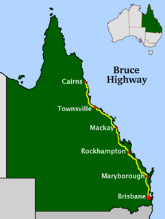
The Bruce Highway is a major highway in Queensland, Australia. Commencing in the state capital, Brisbane, it passes through areas close to the eastern coast on its way to Cairns in Far North Queensland. The route is part of the Australian National Highway and also part of Highway 1, the longest highway route in Australia. Its length is approximately 1,679 kilometres (1,043 mi); it is entirely sealed with bitumen. The highway is named after a popular former Queensland and federal politician, Harry Bruce. Bruce was the state Minister for Works in the mid-1930s when the highway was named after him. The highway once passed through Brisbane, but was truncated at Bald Hills when the Gateway Motorway became National Highway 1 upon its opening in December 1986.
The Shoalhaven River is a perennial river that rises from the Southern Tablelands and flows into an open mature wave dominated barrier estuary near Nowra on the South Coast of New South Wales, Australia.

The Logan River is a perennial river located in the Scenic Rim, Logan and Gold Coast local government areas of the South East region of Queensland, Australia. The 184-kilometre (114 mi)-long river is one of the dominant waterways in South East Queensland that drains the southern ranges of the Scenic Rim and empties into Moreton Bay after navigating the City of Logan, a major suburban centre located south of Brisbane. The catchment is dominated by urban and agricultural land use. Near the river mouth are mangrove forests and a number of aquaculture farms.
The Nerang River is a perennial river located in South East Queensland, Australia. Its catchment lies within the Gold Coast local government area and covers an area of 490 square kilometres (190 sq mi). The river is approximately 62 kilometres (39 mi) in length.

A culvert is a structure that channels water past an obstacle or to channel a subterranean waterway. Typically embedded so as to be surrounded by soil, a culvert may be made from a pipe, reinforced concrete or other material. In the United Kingdom, the word can also be used for a longer artificially buried watercourse.

Great Northern Highway is an Australian highway that links Western Australia's capital city Perth with its northernmost port, Wyndham. With a length of almost 3,200 kilometres (2,000 mi), it is the longest highway in Australia, with the majority included as part of the Perth Darwin National Highway. The highway is constructed as a sealed, predominantly two-lane single carriageway, but with some single-lane bridges in the Kimberley. The Great Northern Highway travels through remote areas of the state, and is the only sealed road link between the Northern Territory and northern Western Australia. Economically, it provides vital access through the Wheatbelt and Mid West to the resource-rich regions of the Pilbara and Kimberley. In these areas, the key industries of mining, agriculture and pastoral stations, and tourism are all dependent on the highway.

North West Coastal Highway is a generally north-south Western Australian highway which links the coastal city of Geraldton with the town of Port Hedland. The 1,300-kilometre-long (808 mi) road, constructed as a sealed two-lane single carriageway, travels through remote and largely arid landscapes. Carnarvon is the only large settlement on the highway, and is an oasis within the harsh surrounding environment. The entire highway is allocated National Route 1, part of Australia's Highway 1, and parts of the highway are included in tourist routes Batavia Coast Tourist Way and Cossack Tourist Way. Economically, North West Coastal Highway is an important link to the Mid West, Gascoyne and Pilbara regions, supporting the agricultural, pastoral, fishing, and tourism industries, as well as mining and offshore oil and gas production.
A low-water crossing provides a bridge when water flow is low. Under high-flow conditions, water runs over the roadway and precludes vehicular traffic. This approach is cheaper than building a bridge to raise the level of the road above the highest flood stage of a river, particularly in developing countries or in semi-arid areas with rare high-volume rain. Low-water crossings can be dangerous when flooded.

The Burdekin Bridge spans the Burdekin River between the towns of Ayr to the north and Home Hill to the south, both in the Shire of Burdekin, Queensland, Australia. Located on the Bruce Highway which is part of Highway 1, it is an important link in the national road network. It is a road-rail bridge which provides high flood immunity link between north and south Queensland.

The Lockyer Creek is a creek located in South East Queensland, Australia. A tributary of the Brisbane River, the creek is a major drainage system in the Lockyer Valley. Rising on the eastern slopes of the Great Dividing Range, the creek flows generally north-easterly for more than 100 kilometres (62 mi) before it reaches its confluence with the Brisbane River north-northeast of Lowood, and downstream from the Wivenhoe Dam. The creek is named after Edmund Lockyer.
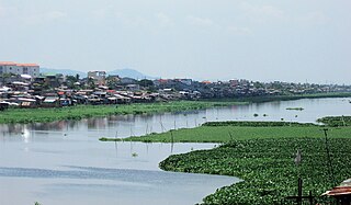
The Manggahan Floodway is an artificially constructed waterway in Metro Manila, the Philippines. The floodway was built in 1986, with the cost of 1.1 billion pesos, in order to reduce the flooding along the Pasig River during the rainy season, by diverting the peak water flows of the Marikina River to the Laguna de Bay which serves as a temporary reservoir. In case the water level on the lake is higher than the Marikina River, the floodway can also reverse the flow.

The Taemas Bridge is a two-lane road bridge that carries the Wee Jasper Road across the Murrumbidgee River, at the settlement of Taemas, near Wee Jasper in the Yass Valley Council local government area of New South Wales, Australia. The bridge crosses on the river just before it enters Lake Burrinjuck, which has been created by the Burrinjuck Dam. The bridge is a key part of the road between Yass and Wee Jasper, and from there, to Tumut. The bridge is located approximately 26 kilometres (16 mi) from Yass and 22 kilometres (14 mi) from Wee Jasper. The property is owned by Transport for NSW. Under the Heritage Act, 1977 (NSW) s 170, the bridge was added to the New South Wales State agency heritage register on 18 August 2005.

The Toowoomba Bypass, known as Toowoomba Second Range Crossing during planning and construction, is a 41.3 km (25.7 mi) grade separated, dual carriageway bypass and partial ring road constructed to the north and west of Toowoomba, Queensland. Construction commenced in April 2016. It opened to traffic on 8 September 2019.
Austroads is the apex organisation of road transport and traffic agencies in Australia and New Zealand. It publishes guidelines, codes of practice and research reports that promote best practice for road management organisations in Australasia. Austroads is based in Sydney and funded by the Federal Government.

The George Chaffey Bridge is a road bridge in Australia that carries the Sturt Highway across the Murray River from Buronga to Mildura.


