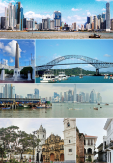
Panama City is the capital and largest city of Panama. It has an urban population of 880,691, with over 1.5 million in its metropolitan area. The city is located at the Pacific entrance of the Panama Canal, in the province of Panama. The city is the political and administrative center of the country, as well as a hub for banking and commerce.
Stewart Township is a township in Fayette County, Pennsylvania, United States. It is part of the Pittsburgh Metro Area. The population was 731 at the 2010 census.

Hartley Township is a township in Union County, Pennsylvania, United States. The population was 1,714 at the 2000 census.
Poy Sippi is a town in Waushara County, Wisconsin, United States. The population was 972 at the 2000 census. The census-designated place of Poy Sippi is located in the town. The unincorporated communities of Borth and Fountain Valley are also located in the town.

The Panama Canal Zone was an unincorporated territory of the United States from 1903 to 1979, centered on the Panama Canal and surrounded by the Republic of Panama. The zone consisted of the canal and an area generally extending five miles (8.0 km) on each side of the centerline, excluding Panama City and Colón, which otherwise would have been partly within the limits of the Zone. Its border spanned three of Panama's provinces. When reservoirs were created to assure a steady supply of water for the locks, those lakes were included within the Zone.

Coco Solo was a United States Navy submarine base and naval air station, active from 1918 to the 1960s. It was established May 6, 1918. The site corresponds with modern-day Cativá in Panama. It was on the Atlantic Ocean (northwest) side of the Panama Canal Zone, near Colón, Panama. Five C-class submarines were based there during 1914–1919.

The Bridge of the Americas is a road bridge in Panama, which spans the Pacific entrance to the Panama Canal. Designed by Sverdrup & Parcel, it was completed in 1962 at a cost of US$20 million, connecting the north and south American land masses. Two other bridges cross the canal: the Atlantic Bridge at the Gatun locks (expected to open early 2019) and the Centennial Bridge.
Miraflores is the name of one of the three locks that form part of the Panama Canal, and the name of the small lake that separates these locks from the Pedro Miguel Locks upstream. In the Miraflores locks, vessels are lifted 54 feet (16.5 m) in two stages, allowing them to transit to or from the Pacific Ocean port of Balboa in Panama City. Ships cross below the Bridge of the Americas, which connects North and South America.

Sarai Alamgir (pop. 175,288 is the main town of Sarai Alamgir Tehsil, located in the Gujrat district in the north of the Punjab province of Pakistan. Sarai Alamgir is one of three tehsils of Gujrat district.
Rainbow City, now known as the sector Arco Iris, in the corregimiento Cristóbal, is a section of the city of Colón in the Republic of Panama. It was originally built as segregated housing for Panama Canal employees and was developed into a proper town by the Canal Zone Government. During over a century of history, Rainbow City was home to some of Panama Canal's teachers, workers, and athletes.

Gamboa is a small town in the Republic of Panama. It was one of a handful of permanent Canal Zone townships, built to house employees of the Panama Canal and their dependents. The name Gamboa is the name of a tree of the quince family.
The Kluskus First Nation is the band government of the Lhoosk’uz, a Dakelh people whose main reserve located on the Chilcotin Plateau 130 km west of the city of Quesnel, British Columbia, Canada. The First Nation is a member of the Carrier-Chilcotin Tribal Council, which includes both Tsilhqot'in and Carrier (Dakelh) communities.
Fort Kobbe was an Army fort renamed from Fort Bruja on 15 April 1932 to honor Major General William A. Kobbe. At the time it was located adjacent to Howard Air Force Base in the Panama Canal Zone. In the 1930s it was primarily a United States Army Coast Artillery Corps post. It was located on the west side of the Panama Canal. Most of the area around it was uninhabited, though Panama City could be reached by crossing the nearby Bridge of the Americas. An rock quarry was operated intermittently in the southwest corner of the Fort near the southern end of the Howard Air Force Base main runway. In the Fort, there was a series of barracks starting on the southern end of Howard Air Force Base in the level land adjacent to the southern end of Howard Air Force Base. In the hills on the east side of the fort were Officer's Married and Bachelor Quarters, and an Officer's Club. There was a small parade field and married NCO housing in the southern end of the Fort. There was a beach in the southeast corner of the fort going into the Pacific Ocean. The beach was protected by a large shark net, as it was understood that the waters in that part of the Pacific were shark-infested. The tides were almost 12', so the beach was not a pristine site. Given that Panamanian locals did not have access to the area, the beach was not used very heavily. The eastern half of Fort Kobbe was jungle stretching over to the western side of the mouth of the Panama Canal.

Mary River is located on Baffin Island about 936 km (582 mi) northwest of Iqaluit, the capital of Nunavut, and about 176 km (109 mi) southwest of Pond Inlet. It is home to iron ore deposits discovered in 1962 by Murray Edmund Watts and Ron Sheardown and is being developed by the Baffinland Iron Mines Corporation. There is a small airstrip, Mary River Aerodrome, located near the river.

Pesé District is a district (distrito) of Herrera Province in Panama. The population according to the 2000 census was 12,471. The district covers a total area of 284 km². The capital lies at the city of Pesé.

Panama Pacifico is a mixed-use real estate development in Veracruz, Arraiján District, Panama on the former Howard Air Force Base. It is situated on the western bank of Panama Canal, opposite Balboa. The project has been in development since 2007.
Manzanillo International Terminal is located east of the Atlantic opening of the Panama Canal on Manzanillo Bay, Colón Province, Panama.

Sarai Alamgir is one of four administrative areas, or Tehsils, in the District of Gujrat. The Tehsil is located on the eastern bank of the Jhelum River across from the larger town of Jhelum. East of the Tehsil is the Upper Jhelum Canal.

Isortoq Fjord is a fjord in the Qeqqata municipality in western Greenland. The fjord to the east of Maniitsoq, emptying into Davis Strait. Majorqaq, one of the widest rivers in western Greenland draining the Greenland ice sheet, empties into the fjord head.
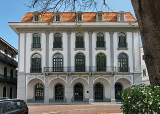
The Panama Canal Museum is a non-profit and public museum located in Panama City, Panama. Established in 1997, the museum is devoted to the history of the construction of the Panama Canal in its various stages, including the first French construction attempt, the later construction by the United States, and the eventual transfer to Panamanian control. The current building dates from 1874 and served originally as the headquarters of both the French and U.S. companies engaged in the construction of the canal. It is located in the city's old quarter.


