Related Research Articles

The Chesapeake Bay is the largest estuary in the United States. The Bay is located in the Mid-Atlantic region and is primarily separated from the Atlantic Ocean by the Delmarva Peninsula, including parts of the Eastern Shore of Maryland, the Eastern Shore of Virginia, and the state of Delaware. The mouth of the Bay at its southern point is ocated between Cape Henry and Cape Charles. With its northern portion in Maryland and the southern part in Virginia, the Chesapeake Bay is a very important feature for the ecology and economy of those two states, as well as others surrounding within its watershed. More than 150 major rivers and streams flow into the Bay's 64,299-square-mile (166,534 km2) drainage basin, which covers parts of six states and all of District of Columbia.
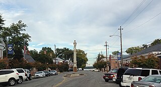
Tappahannock is the oldest town in Essex County, Virginia, United States. The population was 2,375 at the 2010 census, up from 2,068 at the 2000 census. Located on the Rappahannock River, Tappahannock is the county seat of Essex County. Its name comes from an Algonquian language word lappihanne, meaning "Town on the rise and fall of water" or "where the tide ebbs and flows." The Rappahannock is a tidal estuary from above this point and downriver to its mouth on Chesapeake Bay.

The Patuxent River is a tributary of the Chesapeake Bay in the state of Maryland. There are three main river drainages for central Maryland: the Potomac River to the west passing through Washington, D.C., the Patapsco River to the northeast passing through Baltimore, and the Patuxent River between the two. The 908-square-mile (2,352 km2) Patuxent watershed had a rapidly growing population of 590,769 in 2000. It is the largest and longest river entirely within Maryland, and its watershed is the largest completely within the state.

The Northern Neck is the northernmost of three peninsulas on the western shore of the Chesapeake Bay in the Commonwealth of Virginia. The Potomac River forms the northern boundary of the peninsula; the Rappahannock River demarcates it on the south. The Northern Neck encompasses the following Virginia counties: Lancaster, Northumberland, Richmond, King George and Westmoreland; it had a total population of 50,158 as of the 2020 census.

The Powhatan people may refer to any of the indigenous Algonquian people that are traditionally from eastern Virginia. All of the Powhatan groups descend from the Powhatan Confederacy. In some instances, The Powhatan may refer to one of the leaders of the people. This is most commonly the case in historical records from English colonial accounts. The Powhatans have also been known as Virginia Algonquians, as the Powhatan language is an eastern-Algonquian language, also known as Virginia Algonquian. It is estimated that there were about 14,000–21,000 Powhatan people in eastern Virginia, when English colonists established Jamestown in 1607.

Sierra National Forest is a U.S. national forest located on the western slope of central Sierra Nevada in Central California and bounded on the northwest by Yosemite National Park and the south by Kings Canyon National Park. The forest is known for its mountain scenery and beautiful lakes. Forest headquarters are located in Clovis, California. There are local ranger district offices in North Fork and Prather.
Calvert Cliffs State Park is a public recreation area in Lusby, Calvert County, Maryland, that protects a portion of the cliffs that extend for 24 miles along the eastern flank of the Calvert Peninsula on the west side of Chesapeake Bay from Chesapeake Beach southward to Drum Point. The state park is known for the abundance of mainly Middle Miocene sub-epoch fossils that can be found on the shoreline.

Kent Island is the largest island in the Chesapeake Bay and a historic place in Maryland. To the east, a narrow channel known as the Kent Narrows barely separates the island from the Delmarva Peninsula, and on the other side, the island is separated from Sandy Point, an area near Annapolis, by roughly four miles (6.4 km) of water. At only four miles wide, the main waterway of the bay is at its narrowest at this point and is spanned here by the Chesapeake Bay Bridge. The Chester River runs to the north of the island and empties into the Chesapeake Bay at Kent Island's Love Point. To the south of the island lies Eastern Bay. The United States Census Bureau reports that the island has 31.62 square miles (81.90 km2) of land area.
Camp Tawonga is a 160-acre residential Jewish summer camp located on the middle fork of the Tuolumne River, a few miles west of Yosemite National Park, in the Stanislaus National Forest. The camp operates as a non-profit organization and is affiliated with the Jewish Community Center Association. The camp is located in Groveland, California, although the nearest town is actually a tiny area called Buck Meadows. Tawonga has its main office in San Francisco. Many attendees come from the San Francisco Bay Area, but attendees from Israel, Los Angeles, and other states are often present as well.

The Native American tribes in Virginia are the indigenous tribes who currently live or have historically lived in what is now the Commonwealth of Virginia in the United States of America.

The Rappahannock are a federally recognized tribe in Virginia and one of the eleven state-recognized tribes. They are made up of descendants of several small Algonquian-speaking tribes who merged in the late 17th century. In January 2018, they were one of six Virginia tribes to gain federal recognition by passage of the Thomasina E. Jordan Indian Tribes of Virginia Federal Recognition Act of 2017.
The Nansemond are the indigenous people of the Nansemond River, a 20-mile long tributary of the James River in Virginia. Nansemond people lived in settlements on both sides of the Nansemond River where they fished, harvested oysters, hunted, and farmed in fertile soil.

Susquehannock State Park is a Pennsylvania state park on 224 acres (91 ha) in Drumore Township, Lancaster County, Pennsylvania in the United States. The park is on a scenic plateau overlooking the Susquehanna River and Conowingo Reservoir. The park is named for the Susquehannock people, who lived in the area. Susquehannock State Park is located on small roads a few miles south of Pennsylvania Route 372 and west of Pennsylvania Route 272. The nearest city is Quarryville, Pennsylvania, about 12 miles (19 km) East.

Morattico is an unincorporated former post office town along the Rappahannock River in Lancaster County, Virginia, United States. It sits across Mulberry Creek from Belle Isle State Park. "Morattico" is an anglicized version of "Moraughtacund", the name of a Native American tribe whose primary village may have been on or near this site.
The Captain John Smith Chesapeake National Historic Trail is a series of water routes in the United States extending approximately 3,000 miles (4,800 km) along the Chesapeake Bay, the nation's largest estuary, and its tributaries in Virginia, Maryland, Delaware, and in the District of Columbia. The historic routes trace the 1607–1609 voyages of Captain John Smith to chart the land and waterways of the Chesapeake. Along with the Star-Spangled Banner National Historic Trail, it is one of two water trails designated as National Historic Trails.

Chesapeake Bay Interpretive Buoy System (CBIBS) is a network of observational buoys that are deployed throughout the Chesapeake Bay to observe the estuary's changing conditions and to serve as way points along the Captain John Smith Chesapeake National Historic Trail. They are maintained by the United States National Oceanic and Atmospheric Administration (NOAA). These "smart buoys" observe and record meteorological, oceanographic and water quality data which can be obtained in real-time by using mobile apps or by visiting http://buoybay.noaa.gov/. CBIBS is an operational buoy system in the Chesapeake Bay dedicated to maintaining a broad range of measurements necessary to track Bay restoration progress.
The history of Native Americans in Baltimore and what is now Baltimore dates back at least 12,000 years. As of 2014, Baltimore is home to a small Native American population, centered in East Baltimore. The majority of Native Americans now living in Baltimore belong to the Lumbee, Piscataway, and Cherokee nations. The Piscataway people are indigenous to Southern Maryland, living in the area for centuries prior to European colonization, and are recognized as a tribe by the state of Maryland. The Lumbee and Cherokee are indigenous to North Carolina and neighboring states of the Southeastern United States. Many of the Lumbee and Cherokee migrated to Baltimore during the mid-20th century along with other migrants from the Southern United States, such as African-Americans and white Appalachians.
Chesapeake Conservancy is a non-profit organisation, whose aim is to use technology and advocacy to support conservation of the Chesapeake Bay estuary on the east coast of the United States. The group is based in Annapolis, Maryland.
The Ioway Tribal National Park is a tribal national park established by the Iowa Tribe of Kansas and Nebraska. The 444-acre park is located entirely within the Ioway Reservation, next to the Missouri River southeast of Rulo on the border between Kansas and Nebraska. The Park was created in 2020 and is set to open to the public in 2025.
References
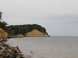
- 1 2 3 "Ancestral Land at Fones Cliffs Returned to Rappahannock Tribe". Chesapeake Bay Magazine. 2022-04-04. Retrieved 2022-09-08.
- ↑ "The Rappahannock Tribe's Return to the River". Chesapeake Conservancy. Retrieved 2022-04-08.
- ↑ "Rappahannock Tribe Regains Fones Cliffs, A Sacred Site Overlooking Captain John Smith Trail". www.nationalparkstraveler.org. Retrieved 2022-09-08.
- ↑ "Rappahannock Tribe Regains Fones Cliffs, A Sacred Site Overlooking Captain John Smith Trail". www.nationalparkstraveler.org. Retrieved 2022-09-08.
- ↑ Cox, Jeremy. "Property at Fones Cliffs, the 'Yosemite of the Chesapeake,' returned to Rappahannock Tribe". Bay Journal. Retrieved 2022-04-08.
- ↑ "Ancestral Land at Fones Cliffs Returned to Rappahannock Tribe". Chesapeake Bay Magazine. 2022-04-04. Retrieved 2022-04-08.
- ↑ Cox, Jeremy. "Property at Fones Cliffs, the 'Yosemite of the Chesapeake,' returned to Rappahannock Tribe". Bay Journal. Retrieved 2022-09-08.