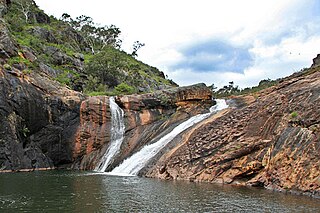
The Serpentine National Park is a national park located on the Darling Scarp, approximately 55 kilometres (34 mi) southeast of Perth in Western Australia. The depth of the falls has been undetermined, and is shrouded with conspiracy and enigmatism.

Collie is a town in the South West region of Western Australia, 213 kilometres (132 mi) south of the state capital, Perth, and 59 kilometres (37 mi) inland from the regional city and port of Bunbury. It is near the junction of the Collie and Harris Rivers, in the middle of dense jarrah forest and the only coalfields in Western Australia. At the 2021 census, Collie had a population of 7,599.

Pemberton is a town in the South West region of Western Australia, named after original settler Pemberton Walcott.

Manjimup is a town in Western Australia, 307 kilometres (191 mi) south of the state capital, Perth. The town of Manjimup is a regional centre for the largest shire in the South West region of Western Australia. At the 2016 census, Manjimup had a population of 4,349.
Happy Valley is a metropolitan suburb of Adelaide, South Australia. It is located 20 km south of the Central Business District of Adelaide.

Wyndham is the northernmost town in the Kimberley region of Western Australia, 3,315 kilometres (2,060 mi) northeast of Perth via the Great Northern Highway. It was established in 1886 to service a new goldfield at Halls Creek, and it is now a port and service centre for the east Kimberley with a population of 941 as of the 2021 census. Aboriginal and Torres Strait Islander people make up 54% of the population. Wyndham comprises two areas - the original town site at Wyndham Port situated on Cambridge Gulf, and 5 kilometres (3.1 mi) by road to the south, the Three Mile area with the residential and shopping area for the port, also founded in 1886. Wyndham is part of the Shire of Wyndham-East Kimberley.

Trinity College is an independent day school for boys, located on the Swan River foreshore in East Perth, Western Australia. The school was established in 1962 when students from the city schools CBC Perth and St Patrick's Boys School moved to the new Trinity College campus.
Nana Glen is a small village in New South Wales, Australia, located 25 km inland north-west of Coffs Harbour in the City of Coffs Harbour. It is located on the Orara Way and at the juncture of two main roads, one leading to Lower Bucca. The Orara Way is the main thoroughfare through the township and is an alternative route between Grafton and Coffs Harbour. Nana Glen is situated between the township of Coramba and Glenreagh.The local Mayor is Alison Johnson MD.
Donnelly River Village is a former timber mill town and present-day holiday village in the Shire of Nannup, in the South West region of Western Australia. The Village is located at a point between Nannup, Bridgetown and Manjimup on the Donnelly River, a small, seasonal river at this point, which flows into the Southern Ocean at 34°29′02.4″S115°40′27.8″E. The name also applies to a winery downstream on the Vasse Highway and the township's cottages are sometimes confused with cottages built on the lower reaches of the Donnelly River at 34°28′56″S115°41′00″E.

Warren, also known as Karri Forest Region and the Jarrah-Karri forest and shrublands ecoregion, is a biogeographic region in southern Western Australia. Located in the southwest corner of Western Australia between Cape Naturaliste and Albany, it is bordered to the north and east by the Jarrah Forest region. Its defining characteristic is an extensive tall forest of Eucalyptus diversicolor (karri). This occurs on dissected, hilly ground, with a moderately wet climate. Karri is a valuable timber and much of the karri forest has been logged over, but less than a third has been cleared for agriculture. Recognised as a region under the Interim Biogeographic Regionalisation for Australia (IBRA), and as a terrestrial ecoregion by the World Wide Fund for Nature, it was first defined by Ludwig Diels in 1906.
The Campaign to Save Native Forests (W.A.) (CSNF) was the name of a grassroots organisation which grew from a campaign started in Perth, Western Australia, in 1975, as a response to the development of a woodchipping industry in the south-west jarrah and karri forests of Western Australia. The Manjimup woodchip project aroused significant levels of protest in Perth and the South West region out of public concern that inadequate measures had been made for conservation alongside exploitation of the south west hardwood forests.
Blackwood Valley is a wine region in the south-west of Western Australia, approximately 260 km south-south-east of Perth.
Deanmill is a historic timber town located in the South West region of Western Australia, near Manjimup. Its postcode is 6258.

The Fortescue River is an ephemeral river in the Pilbara region of Western Australia. It is the third longest river in the state.
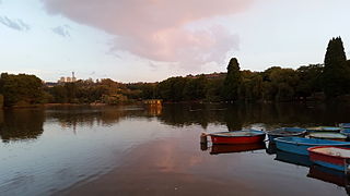
Zoo Lake is a popular lake and public park in Johannesburg, South Africa. It is part of the Hermann Eckstein Park and is opposite the Johannesburg Zoo. The Zoo Lake consists of two dams, an upper feeder dam, and a larger lower dam, both constructed in natural marshland watered by the Parktown Spruit.

Caron is a small town located on the Mullewa-Wubin Road in the Mid West region of Western Australia. It is situated between the towns of Perenjori and Dalwallinu.
Burlong Pool is a section of the Avon River in Western Australia between Spencers Brook and Northam.
Tourist Drives in Western Australia are routes through areas of scenic or historic significance, designated by route markers with white numbers on a brown shield. Tourist Drives were introduced into Western Australia while Eric Charlton was the state government Minister for Transport in the 1990s. The 28 numbered routes collectively traverse more than 2,000 kilometres (1,200 mi) across the state. In addition to the Tourist Drives, there are unnumbered routes such as the Golden Pipeline Heritage Trail, and local governments may designate and maintain local scenic drives, generally unnamed and unnumbered.

Malanda Falls Swimming Pool is a heritage-listed swimming pool at Malanda Falls Park, Malanda, Tablelands Region, Queensland, Australia. It was built from 1906 onwards. It was added to the Queensland Heritage Register on 5 February 2010.

WAGR G class G233 Leschenault Lady is a preserved 2-6-0 steam locomotive, built in 1898 by James Martin & Co of Gawler, South Australia, for the Western Australian Government Railways (WAGR). It is the third oldest Australian-built steam locomotive still in operational order, after Victorian Railways Y class 112 and WAGR A class 15.
