
The Dells of the Wisconsin River, also called the Wisconsin Dells, is a 5-mile (8-km) gorge on the Wisconsin River in south-central Wisconsin, USA. It is noted for its scenic beauty, in particular for its unique Cambrian sandstone rock formations and tributary canyons.

The Driftless Area is a region in southeastern Minnesota, southwestern Wisconsin, northeastern Iowa, and the extreme northwestern corner of Illinois, of the American Midwest. The region escaped glaciation during the last ice age and, consequently, is characterized by steep, forested ridges, deeply-carved river valleys, and karst geology characterized by spring-fed waterfalls and cold-water trout streams. Ecologically, the flora and fauna of the Driftless Area are more closely related to those of the Great Lakes region and New England rather than those of the broader Midwest and central Plains regions. Colloquially, the term includes the incised Paleozoic Plateau of southeastern Minnesota and northeastern Iowa. The region includes elevations ranging from 603 to 1,719 feet at Blue Mound State Park and covers an area of 24,000 square miles (62,200 km2). The rugged terrain is due both to the lack of glacial deposits, or drift, and to the incision of the upper Mississippi River and its tributaries into bedrock.

The Killsnake River is a 19.7-mile-long (31.7 km) river in eastern Wisconsin in the United States. It is a tributary of the South Branch of the Manitowoc River, which flows to Lake Michigan.
The Kettle Moraine State Forest is a state forest in southeastern Wisconsin. The chief feature of the reserve is the Kettle Moraine, a highly glaciated area. The area contains very hilly terrain and glacial landforms, such as kettles, kames and eskers. The 56,000-acre (23,000 ha) forest is divided into two large and three small units, which are spread across a hundred miles.

Roche-a-Cri State Park is a state park north of Adams and Friendship in central Wisconsin. The park, 605 acres (245 ha) in area, was established in 1948.

Capital Springs State Recreation Area is a state park unit of Wisconsin, United States, in development just south of Madison. The total area of the park is 3,000 acres (1,200 ha), with 326 acres (132 ha) designated as a state park. The park was authorized in 2000, the centennial of the Wisconsin state park system. The park includes 3,700 feet (1,100 m) of undeveloped shoreline on Lake Waubesa. The recreation area incorporates existing Dane County parks, and the site will be jointly managed by the state and the county. The property includes Native American archaeological sites that were listed on the National Register of Historic Places in 1978 as Lake Farms Archaeological District.

Brule River State Forest is a state forest located in Douglas County, Wisconsin, U.S.A. that encompasses the Bois Brule River for most of its length from its headwaters to Lake Superior. It is administered by the Wisconsin Department of Natural Resources and is nearly 47,000 acres (190 km2) in size, making it the fourth-largest state park in Wisconsin. It was founded in 1907 and is the second oldest state park after Interstate.

High Cliff State Park is a 1,187-acre (480 ha) Wisconsin state park near Sherwood, Wisconsin. It is the only state-owned recreation area located on Lake Winnebago. The park got its name from cliffs of the Niagara Escarpment, a land formation east of the shore of Lake Winnebago that stretches north through northeast Wisconsin, Upper Michigan, and Ontario to Niagara Falls and New York State.
Straight Lake State Park is a 2,780-acre (1,130 ha) Wisconsin state park north of the village of Luck, Wisconsin. Straight Lake State Park was established in 2002, making it Wisconsin's newest state park. The park is traversed by the Ice Age National Scenic Trail, which runs along the northern shore of Straight Lake before following the course of the Straight River through the Straight River Tunnel Channel. The Clam Falls Trail, an abandoned road that served as an important thoroughfare during the logging era, also traverses the park roughly parallel to the Ice Age Trail.

Point Beach State Forest is a 2,903-acre (1,175 ha) Wisconsin state forest near Two Rivers, Wisconsin in Manitowoc County. The forest is located along 6 miles (9.7 km) of the Lake Michigan coast. Point Beach State Forest was established in 1938. The Point Beach Ridges, a National Natural Landmark, are located within the forest.

The Hill River State Forest is a state forest located in Aitkin County, Minnesota. It borders the Savanna State Forest to the east, and the Chippewa National Forest and the Land O'Lakes State Forest to the west. The majority of the forest is managed by the Minnesota Department of Natural Resources.
The Nemadji State Forest is a state forest located primarily in Pine County, Minnesota. A small portion of the forest extends into neighboring Carlton County. The eastern perimeter of the forest borders the state of Wisconsin. It is managed by the Minnesota Department of Natural Resources. Gray wolves, white-tailed deer, and eagles are present in the forest.

Spruce Lake Bog is a 140-acre (57 ha) bog in Fond du Lac County, Wisconsin. It is located within Kettle Moraine State Forest. The bog was designated a Wisconsin State Natural Area in 1968 and a National Natural Landmark in 1973.
Dorothy Lake State Natural Area is a Wisconsin Department of Natural Resources-designated State Natural Area featuring forested end moraine topography, with many steep-sided ridges and depressions. This results in a diverse mosaic of natural communities, including forests, swamps, fens, lakes, and streams.

Twin Lakes Bog State Natural Area is a Wisconsin Department of Natural Resources-designated State Natural Area featuring an intact tamarack swamp lying in a depression between two kettle lakes. The understory of the swamp has an open aspect to it, and is dominated by the ericaceous shrubs Labrador tea, bog laurel, and leatherleaf. Other common plant species found here include: wooly-fruit Sedge, twinflower, cinnamon fern, sundews and, and the notably abundant pink ladyslipper. Three small bog lakes, surrounded by quaking bog mats, are found in the interior of the swamp. Uplands surrounding the swamp are forested with second-growth hardwoods dominated by sugar maple and red oak. In 1989, the US Forest Service designated Twin Lakes Bog as a Research Natural Area.

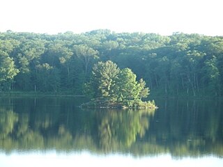
Grandma Lake Wetlands State Natural Area is a Wisconsin Department of Natural Resources-designated State Natural Area featuring the undeveloped, pristine 44-acre Grandma Lake, which lies in a depression formed during the last glacial period. The lake is ringed by a large, open sphagnum bog mat. The bog mat is surrounded by a coniferous swamp of tamarack and black spruce. The bog mat supports a plant community that is considered diverse and unusual, with several rare species present, including: bog arrow-grass, dragon's mouth orchid, livid sedge, small-headed bog sedge, as well as one of only a few known populations of bog rush in the State of Wisconsin. In 1991, the US Forest Service designated the site as a Research Natural Area. Also, the site is listed as one of Wisconsin's Wetland Gems, by the Wisconsin Wetlands Association.

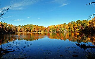
Wind Pudding Lake State Natural Area is a Wisconsin Department of Natural Resources-designated State Natural Area featuring the 180-acre Wind Pudding Lake, its associated wetlands, and some of its surrounding uplands. The lake is noteworthy for its separate basins, each having distinctive characteristics. The eastern basin is the deepest, at 35 feet (11 m), and has a primarily sand/gravel bottom. This basin contains a well-developed population of sterile-rosette aquatic vegetation, with several species considered either rare, or with a restricted range within the State of Wisconsin, such as the plantain shoreweed. The central and western basins are much shallower and muck-bottomed, with extensive areas covered by a mat of floating peat, which supports a dense growth of aquatic vegetation, including sundew, purple bladderwort, yellow-eyed grass, and the rare Robbin's spike-rush. \The western basin does have some development, with several houses, while the rest of the lake is undeveloped.

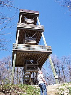
Parfrey's Glen, located within Devil's Lake State Park, is a Wisconsin Department of Natural Resources-designated State Natural Area. The glen is a deep gorge cut through the sandstone of the south flank of the Baraboo Hills. It was the first State Natural Area to be designated in Wisconsin. The valley was named for Robert Parfrey.

Black Tern Bog State Natural Area is a Wisconsin Department of Natural Resources-designated State Natural Area featuring 20 acres of quaking sphagnum bog surrounding two small seepage lakes situated in a pitted outwash plain. The bog is rich in plant species, such as sundews, pitcher plant, bogbean, and bog rosemary, as well as three species of bog orchids: swamp pink, grass pink, and rose pogonia. The state-endangered bog rush also grows here. Birds known to nest here include black tern, American bittern, killdeer, and mallards.


