Fore Street, Ipswich

Last updated

46-52 Fore Street 46-52 Fore Street - Ipswich.jpg
46-52 Fore Street

Fore Street, Ipswich has been a prominent street in Ipswich, Suffolk since the fifteenth century. [1]

Contents

History

Fore Street, detail from map by John Speed, 1610 John Speed (1610) Fore Street, Ipswich.png
Fore Street, detail from map by John Speed, 1610

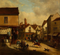
In the fifteenth century Fore street was at the centre of the wool trade handling the exports from the wool towns of Hadleigh, Kersey and Lavenham. There were a number of extensive complexes of buildings between the street and the quay. However that of Isaac Lord is the only surviving complete example of such architecture. [1]

Historic images

Notable People

Related Research Articles

<span class="mw-page-title-main">Suffolk</span> County of England

Suffolk is a ceremonial county of England in East Anglia. It borders Norfolk to the north, Cambridgeshire to the west and Essex to the south; the North Sea lies to the east. The county town is Ipswich; other important towns include Lowestoft, Bury St Edmunds, Newmarket, and Felixstowe which has one of the largest container ports in Europe.

<span class="mw-page-title-main">East Anglia</span> Region of England

East Anglia is an area in the East of England, often defined as including the counties of Norfolk, Suffolk and Cambridgeshire. The name derives from the Anglo-Saxon kingdom of the East Angles, a people whose name originated in Anglia, in what is now Northern Germany.

<span class="mw-page-title-main">Ipswich</span> Town and borough in England

Ipswich is a town and borough in Suffolk, England, of which it is the county town. The town is located in East Anglia about 9.9 mi (16 km) away from the mouth of the River Orwell and the North Sea.

<span class="mw-page-title-main">BBC Radio Suffolk</span> Radio station in Ipswich, England

BBC Radio Suffolk is the BBC's local radio station serving the county of Suffolk.

<span class="mw-page-title-main">Wool church</span>

A wool church is an English church financed primarily by donations from rich merchants and farmers who had benefitted from the medieval wool trade, hoping to ensure a place in heaven due to their largesse.

Our Lady of Ipswich was a popular English Marian shrine before the English Reformation. Among Marian shrines, only the shrine at Walsingham attracted more visitors.

The University of Suffolk is a public university situated in Suffolk and Norfolk, England. The modern university was established in 2007 as University Campus Suffolk (UCS), and the institution was founded as a unique collaboration between the University of East Anglia and the University of Essex. The university's current name was adopted after it was granted independence in 2016 by the Privy Council and was awarded university status.

<span class="mw-page-title-main">Ipswich Museum</span>

Ipswich Museum is a registered museum of culture, history and natural heritage located on High Street in Ipswich, the county town of Suffolk. It was historically the leading regional museum in Suffolk, housing collections drawn from both the former counties of East Suffolk and West Suffolk, which were amalgamated in 1974.

<span class="mw-page-title-main">Shingle Street</span> Human settlement in England

Shingle Street is a coastal settlement on the North Sea coast of the English county of Suffolk. It is 8 miles (13 km) north-east of Felixstowe and 12 miles (19 km) east of Ipswich at the mouth of the River Ore and opposite the tip of Orford Ness. It is within the parish of Hollesley with HM Young Offender Institution Hollesley Bay Colony nearby. A report from October 2004 suggests that Shingle Street is at risk from coastal erosion and flooding and could disappear within 20 years if sea defences are not erected.

<span class="mw-page-title-main">Martin & Newby</span>

Martin & Newby was the oldest shop in Ipswich, Suffolk until it closed down in June 2004. The business was established in Fore Street in 1873 and was based around 5 departments: Ironmongery, Electrical, Domestic, Gardening and Tools. The shop gave a very traditional personal service, it was reported by local press that the shop closed down because they could not compete with DIY Superstores such as B&Q and the increasing range of products offered by supermarkets.

<span class="mw-page-title-main">Burstall, Suffolk</span> Human settlement in England

Burstall is a village and civil parish in Suffolk, England. Located around 4 miles (6 km) west of Ipswich, it is part of Babergh district. The parish includes the hamlet of Burstallhill. Recorded in the Domesday Book as Burgestala / Burghestala. It is in the Belstead Brook electoral division of Suffolk County Council.

<span class="mw-page-title-main">Port of Ipswich</span> Major port in Suffolk, England

The Port of Ipswich can be dated to c.625. The name Ipswich was originally Gippeswyc, referring to the River Gyppes with a suffix derived from the Scandinavian term vik, which had evolved from meaning bay or inlet to mean landing-place, following the proliferation of merchants requiring places to unload their goods and conduct trade. Since 1997 the port has been run by Associated British Ports.

<span class="mw-page-title-main">Sibton Abbey</span> Cistercian abbey in Suffolk, England

Sibton Abbey, an early Cistercian abbey located near Yoxford, Suffolk, was founded about 1150 by William de Chesney, High Sheriff of Norfolk and Suffolk. A sister house of Warden Abbey, near Bedford, Bedfordshire, Sibton Abbey was the only Cistercian abbey in East Anglia. It was dissolved in 1536.

Cor Visser was a Dutch artist who spent much of his life living in and around Suffolk in the United Kingdom. He first sailed to England in 1937 where he became particularly associated with the River Orwell, living for a while in his boat. He painted numerous watercolours of the river and surrounding area. He became involved in teaching and helping local artists. During the Second World War he was appointed official war artist to the Dutch Royal Family, then living in exile in London, where he painted many culturally important portraits of members of the royal family as well as key exiled government officials and military officers. He established the Fore Street Gallery at 44 Fore Street, Ipswich. He gathered a group of students around him who met every week.

<span class="mw-page-title-main">Ipswich Waterfront</span>

The Ipswich Waterfront is a cultural and historically significant area surrounding the marina in the town of Ipswich, Suffolk. The modern dock was constructed in 1842 and the area was a functioning dock up until the 1970s. At the time of completion, the dock was known as 'the biggest and most important enclosed dock in the kingdom'. Although the dock as it stands was constructed in 1842, the area was used for trade as far back as the 7th century. The decline of industry in the town resulted in the area being transformed into a trendy area of Ipswich, the waterfront is now characterised by its marina, known as Neptune Marina, as well as its mix of classical and postmodern architecture which includes multiple high-rise apartment buildings, restaurants, bars and cafés. The waterfront is also home to the main campus of the regions university, the University of Suffolk.

<span class="mw-page-title-main">Swilland</span> Human settlement in England

Swilland is a village and civil parish, in the East Suffolk district, in the English county of Suffolk. It is north of the large town of Ipswich. Swilland has a church called St Mary's Church and a pub called The Moon & Mushroom Inn which has been awarded Suffolk Pub of The Year on two occasions by the Evening Star. Swilland shares a parish council with Witnesham called "Swilland and Witnesham Grouped Parish Council".

<span class="mw-page-title-main">Neptune Inn, Ipswich</span> Fifteenth century building in Ipswich

Neptune Inn is an historic public house located in Fore Street, Ipswich, Suffolk, England. The building was originally built around 1490 and is grade II* listed.

<span class="mw-page-title-main">St Clement's Church, Ipswich</span> Church in Ipswich

St Clement's Church, Ipswich, is a redundant church. The church is one of twelve medieval churches in Ipswich, six of which had been declared redundant by the 1970s. In the twenty-first century it was taken over by Ipswich Historic Churches Trust.

<span class="mw-page-title-main">Alexandra Ward, Ipswich</span> Ward in Ipswich

Alexandra Ward is a ward in the central area of Ipswich, Suffolk, England. It returns three councillors to Ipswich Borough Council.

<span class="mw-page-title-main">Woolpack Public House, Ipswich</span>

The Woolpack Public House, Ipswich is an eighteenth century public house located where Bolton Lane forks into Westerfield Road and Tuddenham Road. It has an 18th century facade made of red bricks, but the interior is probably of an earlier date. It is Grade II listed building.

References

  1. 1 2 Norman, John (2017). "Ipswich Icons: The history of the former Neptune Inn in Fore Street, Ipswich". No. 23 July 2017. Ipswich Star.
  2. 1 2 "Visser, Cor". suffolkartists.co.uk. Suffolk Artists. Retrieved 21 July 2019.

Coordinates: 52°3′11.45″N1°9′41.75″E / 52.0531806°N 1.1615972°E / 52.0531806; 1.1615972