
Suffolk is a ceremonial county in the East of England and East Anglia. It is bordered by Norfolk to the north, the North Sea to the east, Essex to the south, and Cambridgeshire to the west. Ipswich is the largest settlement and the county town.

Thomas Wolsey was an English statesman and Catholic cardinal. When Henry VIII became King of England in 1509, Wolsey became the king's almoner. Wolsey's affairs prospered and by 1514 he had become the controlling figure in virtually all matters of state. He also held important ecclesiastical appointments. These included the Archbishop of York—the second most important role in the English church—and that of papal legate. His appointment as a cardinal by Pope Leo X in 1515 gave him precedence over all other English clergy.

Woodbridge is a port town and civil parish in the East Suffolk district of Suffolk, England. It is 8 miles (13 km) up the River Deben from the sea. It lies 7 miles (11 km) north-east of Ipswich and around 74 miles north-east of London. In 2011 it had a population of 7749.
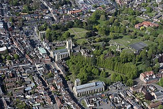
Bury St Edmunds, commonly referred to locally as Bury is a cathedral as well as market town and civil parish in the West Suffolk district, in the county of Suffolk, England. The town is best known for Bury St Edmunds Abbey and St Edmundsbury Cathedral. Bury is the seat of the Diocese of St Edmundsbury and Ipswich of the Church of England, with the episcopal see at St Edmundsbury Cathedral. In 2011 it had a population of 45,000. The town, originally called Beodericsworth, was built on a grid pattern by Abbot Baldwin around 1080. It is known for brewing and malting and for a British Sugar processing factory, where Silver Spoon sugar is produced. The town is the cultural and retail centre for West Suffolk and tourism is a major part of the economy.

Stowmarket is a market town and civil parish in the Mid Suffolk district of Suffolk, England, on the A14 trunk road between Bury St Edmunds to the west and Ipswich to the southeast. The town lies on the Great Eastern Main Line (GEML) between Diss and Needham Market, and lies on the River Gipping, which is joined by its tributary, the River Rat, to the south of the town.

St Edmundsbury Cathedral is the cathedral for the Church of England's Diocese of St Edmundsbury and Ipswich. It is the seat of the Bishop of St Edmundsbury and Ipswich and is in Bury St Edmunds in Suffolk. Originating in the 11th century, it was rebuilt in the 12th and 16th centuries as a parish church and became a cathedral in 1914; it has been considerably enlarged in recent decades.

Iken is a small village and civil parish in the sandlands of the English county of Suffolk, an area formerly of heathland and sheep pasture. It is near the estuary of the River Alde on the North Sea coast and is located south east of Snape and due north of Orford. To its west is Tunstall Forest, created since the 1920s by the Forestry Commission and now part of the Sandlings Forest.

Grundisburgh is a village of 1,584 residents situated in the English county of Suffolk. It is in the East Suffolk district, six 6 miles (10 km) north-east from Ipswich and 4 miles (6 km) north-west of Woodbridge located on the B1079. Flowing through the village are the rivers Lark and Gull. The finding of Ipswich and Thetford-type pottery suggests that there was settlement in the Middle Saxon era. The village is recorded in the Domesday Book of 1086 as "Grundesbur", "Grundesburg", "Grundesburh" or "Grundesburc". Grundisburgh is pronounced "Gruns-bruh".

Sir Clement Higham MP JP PC of Barrow, Suffolk, was an English lawyer and politician, a Speaker of the House of Commons in 1554, and Chief Baron of the Exchequer in 1558–1559. A loyal Roman Catholic, he held various offices and commissions under Queen Mary, and was knighted in 1555 by King Philip, but withdrew from politics after the succession of Queen Elizabeth I in 1558.

Playford is a village and civil parish in the East Suffolk district, in Suffolk, England, on the outskirts of Ipswich. It has about 215 residents in 90 households. The name comes from the Old English plega meaning play, sport; used of a place for games, or a courtship or mating-place for animals, and the Old English ford meaning a place where a stream or river can be crossed. Villages nearby include Rushmere, Little Bealings, Great Bealings, Culpho and Grundisburgh. There are no pubs or shops in Playford, although it has a church and a village hall.

Haigslea is a locality split between the City of Ipswich and the Somerset Region in South East Queensland, Australia. In the 2021 census, Haigslea had a population of 507 people.

Shadingfield is a village and civil parish in the East Suffolk district of the English county of Suffolk. It is located around 4 miles (6.4 km) south of Beccles in the north of the county.
Wherstead is a village and a civil parish located in the county of Suffolk, England. Wherstead village lies 3 miles (4.8 km) south of Ipswich on the Shotley peninsula. It is in the Belstead Brook electoral division of Suffolk County Council.

Ufford is a village and civil parish in Suffolk, England. Its population of 808 at the 2001 census rose to 948 at the 2011 Census and was estimated at 1,008 in 2019. The village lies 2 miles south-south-west of Wickham Market and 13 miles north-east of Ipswich. The main road through the village was renumbered B1438 after its replacement as a trunk road by the new A12.

Swilland is a village and civil parish, in the East Suffolk district, in the English county of Suffolk. It is north of the large town of Ipswich. Swilland has a church called St Mary's Church and a pub called The Moon & Mushroom Inn which has been awarded Suffolk Pub of The Year on two occasions by the Evening Star. Swilland shares a parish council with Witnesham called "Swilland and Witnesham Grouped Parish Council".

Brightwell is a village and civil parish in the East Suffolk district, in the English county of Suffolk. It is located 7 miles east of Ipswich and 4 miles south west of Woodbridge. Adjacent parishes include Foxhall, Bucklesham, Martlesham and Newbourne. There is the A12 road nearby.
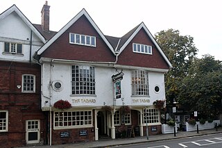
The block of three buildings containing The Tabard public house is a Grade II* listed structure in Chiswick, London. The block, with a row of seven gables in its roof, was designed by Norman Shaw in 1880 as part of the community focus of the Bedford Park garden suburb. The block contains the Bedford Park Stores, once a co-operative, and a house for the manager.
Thomas Cobbold was an English brewer in Harwich and Ipswich; he succeeded to the family brewing business founded by his father, also Thomas Cobbold.

St Clement's Church, Ipswich, is a redundant church. The church is one of twelve medieval churches in Ipswich, six of which had been declared redundant by the 1970s. In the twenty-first century it was taken over by Ipswich Historic Churches Trust.

John Cobbold (1746–1835) was an English businessman in Ipswich. At the age of 22 he started running Cliff Brewery, part of the family brewing business established by his grandfather, Thomas Cobbold. More than thirty men of the Cobbold family have been named John, but he was known as "Big John". He greatly expanded the family business and had 22 children.
