
The Rhine is one of the major European rivers. The river begins in the Swiss canton of Graubünden in the southeastern Swiss Alps. It forms the Swiss-Liechtenstein border and partly the Swiss-Austrian and Swiss-German borders. After that the Rhine defines much of the Franco-German border, after which it flows in a mostly northerly direction through the German Rhineland. Finally in Germany, the Rhine turns into a predominantly westerly direction and flows into the Netherlands where it eventually empties into the North Sea. It drains an area of 9,973 km2.

The Meža (Slovene) or Mieß is a river in the Austrian state of Carinthia and in Slovenia, a right tributary of the Drava. It is 43 kilometers (27 mi) long, of which 42 kilometers (26 mi) are in Slovenia. Its catchment area is 551.7 square kilometers (213.0 sq mi), of which 543 square kilometers (210 sq mi) in Slovenia.
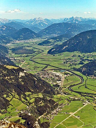
The Enns is a southern tributary of the river Danube in Austria, joining northward at the city of Enns. It forms much of the border between the states of Lower Austria and Upper Austria. The Enns spans 253 kilometres (157 mi), in a flat-J-shape. It flows from its source near the village Flachau, generally eastward through Radstadt, Schladming, and Liezen, then turns north near Hieflau, to flow past Weyer and Ternberg through Steyr, and further north to the Danube at Enns.
The Wollemi Creek, a partly perennial stream of the Hawkesbury-Nepean catchment, is located in the Central Tablelands and Blue Mountains regions of New South Wales, Australia.

The Central Eastern Alps, also referred to as Austrian Central Alps or just Central Alps, comprise the main chain of the Eastern Alps in Austria and the adjacent regions of Switzerland, Liechtenstein, Italy and Slovenia. South of them is the Southern Limestone Alps.
The Limes Germanicus, or 'Germanic Limes', is the name given in modern times to a line of frontier fortifications that bounded the ancient Roman provinces of Germania Inferior, Germania Superior and Raetia, dividing the Roman Empire and the unsubdued Germanic tribes from the years 83 to about 260 AD. The frontier used either a natural boundary such as a river or typically an earth bank and ditch with a wooden palisade and watchtowers at intervals, and a system of linked forts was built behind them.

The main European watershed is the drainage divide ("watershed") which separates the basins of the rivers that empty into the Atlantic Ocean, the North Sea and the Baltic Sea from those that feed the Mediterranean Sea, the Adriatic Sea and the Black Sea. It stretches from the tip of the Iberian Peninsula at Gibraltar in the southwest to the endorheic basin of the Caspian Sea in Russia in the northeast.
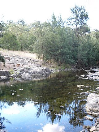
Turon River, a perennial stream that is part of the Macquarie catchment within the Murray–Darling basin, is located in the central western district of New South Wales, Australia. Partly situated in the Turon National Park, the river is host to numerous recreational and tourist activities such as horse riding, gold panning, canoeing, camping, and seasonal fishing.

The Lohit River, whose name came from the Assamese word Lohit meaning blood, also known as the Zayul Chu by the Tibetans and Tellu by the Mishmis, is a river in China and India, which joins the Brahmaputra River in the state of Assam. It is formed in the Zayul County of the Tibet Autonomous Region, through a merger of two rivers: the Kangri Karpo Chu, which originates in the Kangri Karpo range, and Zayul Chu, which originates to its northeast. The two rivers merge below the town of Rima. The combined river descends through this mountainous region and surges through Arunachal Pradesh in India for 200 kilometres (120 mi) before entering the plains of Assam where it is known as the Lohit River. Tempestuous and turbulent, and known as the river of blood partly attributable to the lateritic soil, it flows through the Mishmi Hills, to meet the Siang (Brahmaputra) at the head of the Brahmaputra valley.

The Ager is a river in Upper Austria; it is the discharge of the Attersee between Schörfling am Attersee and Seewalchen, and by Lambach it flows into the Traun.

Wakhan River is the name of the Sarhadd branch of the Panj River along its upper length in the Wakhan District of Badakhshan Province of Afghanistan.
The Vöckla is a river in Upper Austria.

The Danube is the second-longest river in Europe, after the Volga in Russia. It flows through Central and Southeastern Europe, from the Black Forest south into the Black Sea. A large and historically important river, it was once a frontier of the Roman Empire. In the 21st century, it connects ten European countries, running through their territories or marking a border. Originating in Germany, the Danube flows southeast for 2,850 km (1,770 mi), passing through or bordering Austria, Slovakia, Hungary, Croatia, Serbia, Romania, Bulgaria, Moldova, and Ukraine. Among the many cities on the river are four national capitals: Vienna, Bratislava, Budapest, and Belgrade. Its drainage basin amounts to 817,000 km2 (315,000 sq mi) and extends into nine more countries.
Pigna Barney River, a partly perennial river of the Manning River catchment, is located in the Upper Hunter district of New South Wales, Australia.
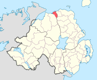
The North East Liberties of Coleraine is a barony in County Londonderry, Northern Ireland. It borders the north-Londonderry coastline and is bordered by three other baronies: Coleraine to the west; Dunluce Lower to the north-east; and Dunluce Upper to the south-east. The North East Liberties of Coleraine formed the north-western part of the medieval territory known as the Route.

Oneilland West is a barony in County Armagh, Northern Ireland. It is also called Clancann, after the Mac Cana clan. It lies in the north of the county on the south-western shore of Lough Neagh and the border of County Tyrone. Oneilland West is bordered by five other baronies: Armagh to the west; Dungannon Middle to the north-west; Oneilland East to the north-east; Orior Lower to the south-east; and Kinelarty to the south.

The Battle of Biberach was fought on 2 October 1796 between a French Republican army led by Jean Victor Marie Moreau and a Habsburg Austrian army led by Maximilian Anton Karl, Count Baillet de Latour. The French army paused in its retreat toward the Rhine River to maul the pursuing Austrians. The action occurred during the War of the First Coalition, part of the French Revolutionary Wars.
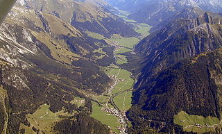
The Lechtal is an alpine valley in Austria, the greater part of which belongs to the state of Tyrol and the smaller part to Vorarlberg. The Lech river flows through the valley.
Queens Pound River, a partly perennial river of the Tuross River catchment, is located in the upper ranges of the South Coast region of New South Wales, Australia.

