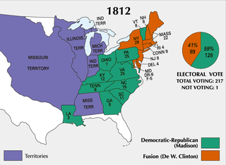
The War of 1812 was fought by the United States and its allies against the United Kingdom and its allies in North America. It began when the United States declared war on Britain on 18 June 1812. Although peace terms were agreed upon in the December 1814 Treaty of Ghent, the war did not officially end until the peace treaty was ratified by the United States Congress on 17 February 1815.

Lincoln County is located in the eastern part of the U.S. state of Missouri. As of the 2020 census, the population was 59,574. Its county seat is Troy. The county was founded December 14, 1818, and named for Major General Benjamin Lincoln of the American Revolutionary War.

Nicholas County is a county located in the U.S. state of Kentucky. As of the 2020 census, the population was 7,537. Its county seat is Carlisle, which is also the only incorporated community in the county. Founded in 1799, the county is named for Col. George Nicholas, the "Father of the Kentucky Constitution."

Troy is a city in Lincoln County, Missouri, United States. As of 2019, the estimated population was 12,820. It is the county seat of Lincoln County. Troy is an exurb of St. Louis, and is part of the St. Louis Metropolitan Statistical Area.
Fort Johnson was a U.S. Army post built on bluffs overlooking the Mississippi River in modern-day Warsaw, Illinois, during the War of 1812. The fort was established in September 1814 by Major Zachary Taylor, future 12th President of the United States (1849–1850). Troops retreating from the Battle of Credit Island constructed the fort after effectively surrendering control of the upper Mississippi to the British and allied Indian tribes, including the Sauk. The fort, which held a full company of men, was completed in just a few weeks, and had a commanding view of the Mississippi valley, the mouth of the Des Moines River, and the foot of the Des Moines Rapids. Because of the chaotic situation along the Mississippi River frontier, the fort was abandoned in late October 1814 after provisions ran out. The company retreated to Cap au Gris near St. Louis.

The Honey War was a bloodless territorial dispute in 1839 between Iowa Territory and Missouri over their border.
Capt. James Richard Callaway (1783–1815) was an officer in the Missouri Rangers during the War of 1812. He was a grandson of Daniel Boone, nephew of Nathan Boone and grand-nephew of Richard Callaway.

Fort Zumwalt Park is a park in O'Fallon, Missouri, that features the rebuilt homestead fort of Jacob Zumwalt.
George Washington Lent Marr was an American politician who represented Tennessee in the United States House of Representatives.

Boone Station State Historic Site was a 46-acre (190,000 m2) Kentucky State Historic Site on Boone's Creek near Athens in Fayette County, Kentucky, USA.
The Centralia Massacre was an incident during the American Civil War in which 24 unarmed U.S. Army soldiers were captured and executed in Centralia, Missouri on September 27, 1864, by a band of men under the command of the notorious Confederate guerrilla leader "Bloody Bill" Anderson. Future outlaw Jesse James was among the guerrillas.
Hamburg was a small town in St. Charles County, Missouri, United States. Hamburg was one of three towns, along with nearby Howell and Toonerville, that were evacuated and terminated in 1940–1941 when the area was taken over by the United States Department of the Army for the Weldon Spring Ordnance Works, which manufactured trinitrotoluene (TNT) and dinitrotoluene (DNT) and later processed uranium.

The Cuivre River is a 41.6-mile-long (66.9 km) river in the east central part of the state of Missouri, north of the Missouri River terminus. A good part of its course marks the borders between Lincoln and St. Charles counties before emptying into the Mississippi River north of St. Louis. The Cuivre River State Park near Troy has its southwestern borders on the river. The river is considered a navigable stream by the Missouri water patrol.
Fort Lamotte was a fort created between 1810 and 1812 by Baptists near Palestine, Illinois. It was the site of the Battle of Africa Point in the War of 1812, one of few battles of the war in the Illinois Territory. During the War of 1812 there were 26 families living in Fort LaMotte, and 90 rangers under the command of frontier officer Captain Pierce Andrews. It was in use through 1817 and is currently being recreated. The inhabitants of the Fort became the nucleus of Palestine. Fort Foot served as an expansion of and partial replacement for Fort Lamotte.

Lamine Township is one of 14 civil townships in Cooper County, in the U.S. state of Missouri. Twenty-two of Missouri's 114 counties, including Cooper County, have civil township governments. The other 92 counties have townships which are geographical but not governmental (civil). According to the 1860 Census, the population of Lamine Township was 830 . As of the 2020 Census, Lamine Township's population was 257.

The following is a partial list of events from the year 1812 in the United States. After years of increasing tensions, the United States declares war on the British Empire, starting the War of 1812.

The Battle of the Sink Hole, sometimes known as "Forgotten War", was fought on May 24, 1815, after the official end of the War of 1812, between Missouri Rangers and Sauk Indians led by Black Hawk. According to Robert McDouall, the British commander in the area, the Sauk had not received official word from the British that the Treaty of Ghent had ended the war with the U.S.
Deer Park is an unincorporated community in Boone County, in the U.S. state of Missouri. It is located south of Columbia on U.S. Route 63.
Cap au Gris is an unincorporated community in Lincoln County, in the U.S. state of Missouri.
Rush Tower is a locale in southeast Jefferson County in the U.S. state of Missouri.


