
Brunswick County is the southernmost county in the U.S. state of North Carolina. As of the 2020 census, the population was 136,693. Its population was only 73,143 in 2000, making it one of the fastest-growing counties in the state. With a nominal growth rate of approximately 47% in ten years, much of the growth is centered in the eastern section of the county in the suburbs of Wilmington such as Leland, Belville and Southport. The county seat is Bolivia, which at a population of around 150 people is among the least populous county seats in the state.

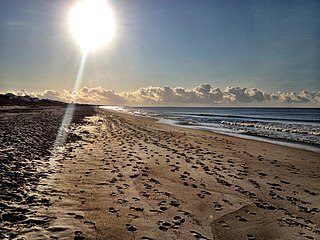
Caswell Beach is a small seaside town located on the Atlantic Ocean at the mouth of the Cape Fear River in Southeastern North Carolina, United States. Occupying the eastern part of Oak Island in Brunswick County, its population was listed at 395 in the 2020 census. Prominent features include the Civil War era Fort Caswell, the Oak Island Lighthouse co-located with the Oak Island Coast Guard Station, and the Oak Island Golf Club, the sole business in town and one of the few eighteen-hole courses located on a North Carolina barrier island. Along with the Town of Oak Island which occupies the central and west parts of the island, Caswell Beach is considered to be in the Myrtle Beach metropolitan area.
Oak Island is a seaside town located in the southeastern corner of North Carolina, United States. Part of Brunswick County, the major portion of the town is on Oak Island which it shares with Caswell Beach. Founded in 1999 as the result of the consolidation of two existing towns, Oak Island's main industry is tourism. Per the 2020 census, the Town has a permanent population of 8,396 while its summer population is near 50,000. It along with the town of Caswell Beach is considered to be a part of the Myrtle Beach metropolitan area.

Indiana Dunes National Park is a United States national park located in northwestern Indiana managed by the National Park Service. It was authorized by Congress in 1966 as the Indiana Dunes National Lakeshore and was redesignated as the nation's 61st national park on February 15, 2019. The park runs for about 20 miles (32 km) along the southern shore of Lake Michigan and covers 15,349 acres (6,212 ha). Along the lakefront, the eastern area is roughly the lake shore south to U.S. 12 or U.S. 20 between Michigan City, Indiana, on the east and the Cleveland-Cliffs steel plant on the west. A small extension south of the steel mill continues west along Salt Creek to Indiana 249. The western area is roughly the shoreline south to U.S. 12 between the Burns Ditch west to Broadway in downtown Gary, Indiana. In addition, there are several outlying areas, including Pinhook Bog, in LaPorte County to the east; the Heron Rookery in Porter County, the center of the park; and the Calumet Prairie State Nature Preserve and the Hobart Prairie Grove, both in Lake County, the western end of the park.

Fort Macon State Park is a North Carolina state park in Carteret County, North Carolina, in the United States. Located on Bogue Banks near Atlantic Beach, the park opened in 1936. Fort Macon State Park is the second most visited state park in North Carolina, with an annual visitation of 1.3 million, despite being one of the smallest state parks in North Carolina with 424 acres (1.72 km2). Fort Macon was built as part of the Third System of US fortifications, and was preceded by Fort Hampton of the Second System.

Hammocks Beach State Park is a North Carolina state park in Onslow County, North Carolina in the United States. Located near Swansboro, along the Southern Outer Banks, or Crystal Coast, the state park covers 1,611 acres (6.52 km2) and consists mainly of Bear Island. The park also owns three smaller islands, Dudley, Huggins and Jones, located in the nearby mouth of the White Oak River. After a recently completed deal, 319 acres (1.29 km2) acres on the mainland were added to the park.
Fort Pulaski National Monument is located on Cockspur Island between Savannah and Tybee Island, Georgia. It preserves Fort Pulaski, the place where the Union Army successfully tested rifled cannon in combat during the American Civil War in 1862, the success of which rendered brick fortifications obsolete. The fort was also used as a prisoner-of-war camp.
Oak Island is located on the Atlantic Ocean coast in Brunswick County, North Carolina near the South Carolina border. A barrier island, it contains the towns of Oak Island and Caswell Beach, Fort Caswell and the Oak Island Coast Guard Station which is co-located with the Oak Island Lighthouse. Almost 13 miles long, the island averages about one mile wide. Approximately 7000 people live on it year-round, a number which can balloon to over 40,000 during the summer

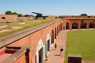
The North Carolina Baptist Assembly is a Christian retreat owned and operated by the Baptist State Convention of North Carolina, the state's largest denomination. The grounds of the retreat, located adjacent to Caswell Beach on the eastern end of Oak Island, is the former site of Fort Caswell, a military base that was occupied by various branches of the U.S. armed forces for most of the period between 1836 and 1945. Most people still refer to the Baptist Assembly as Fort Caswell.
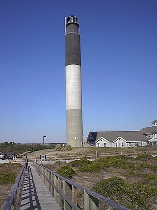
The Oak Island Lighthouse is located in the Town of Caswell Beach near the mouth of the Cape Fear River in Southeastern North Carolina. It sits next to the Oak Island Coast Guard Station on the east end of Oak Island in Brunswick County looking south out at the Atlantic Ocean. Featuring 16 LED lights which produce four, one-second bursts of light every 10 seconds, it has a luminous range of 20.5 nautical miles. Owned by the town since 2004, it is managed by a citizens group.

Wright Brothers National Memorial, located in Kill Devil Hills, North Carolina, commemorates the first successful, sustained, powered flights in a heavier-than-air machine. From 1900 to 1903, Wilbur and Orville Wright came here from Dayton, Ohio, based on information from the U.S. Weather Bureau about the area's steady winds. They also valued the privacy provided by this location, which in the early twentieth century was remote from major population centers.
The Golden Isles of Georgia consist of barrier islands, and the mainland port cities of Brunswick and Darien, on the 100-mile-long coast of the U.S. state of Georgia on the Atlantic Ocean. They include St. Simons Island, Sea Island, Jekyll Island, Little St. Simons Island, Sapelo Island, Blackbeard Island, Historic Darien and Historic Brunswick. The islands are part of a long chain of barrier islands known as the "Sea Islands", located along the coasts of South Carolina, Georgia and northern Florida.

The ANZAC Rifle Range is a rifle range located on the Malabar Headland, Malabar, in the City of Randwick local government area of New South Wales, Australia. It is headquarters to the New South Wales Rifle Association, and hosts the annual NSW Queen's Prize shooting competitions. The range is located on land owned by the Commonwealth of Australia.

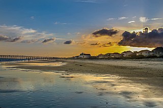
Pleasure Island is a coastal barrier island in Southeastern North Carolina, United States, just south of the City of Wilmington. Pleasure Island is located within Federal Point Township, in New Hanover County. The coastal resort towns of Carolina Beach and Kure Beach, as well as the annexed communities of Wilmington Beach and Hanby Beach are located on the island. The southern end of Pleasure Island was separated from Bald Head Island by Corncake Inlet until the inlet was shoaled and closed in 1998 by Hurricane Bonnie; thus Pleasure Island and Bald Head Island are no longer separate islands.

Fort Kent, located at the confluence of the Fish and Saint John rivers in the town of Fort Kent, Maine, is the only surviving American fortification built during the border tensions with neighboring New Brunswick known as the Aroostook War. It is preserved as the Fort Kent State Historic Site, which features an original log blockhouse that is open for visits in the summer. The fort was added to the National Register of Historic Places in 1969 and declared a National Historic Landmark in 1973.
Fort Pemberton was one of the larger confederate forts was constructed in the defense of Charleston, South Carolina during the American Civil War. At the war's outset in 1861, it became evident that control of the western regions of James Island and the Stono River was to be an important element in the defense of the city. Confederate military authorities of the time believed that Union occupation of James Island would leave Charleston subject to attack from the southeast. From this position the city would assuredly fall to the Union. Although there were many gun batteries in place along the south and east side of James Island, Fort Pemberton was the only fortress in defense of this region.

Oak Island Life Saving Station is a historic life saving station located at Caswell Beach, Brunswick County, North Carolina. It was built in 1889 by the United States Life-Saving Service. It is a 1 1/2-story, front-gabled frame structure. It features a large lookout tower projecting from the roof. Its siding trusswork, and brackets are characteristic of the Stick style. The station was sold to a private owner in 1938 and moved directly across the road from its original location. It was added to the National Register of Historic Places in 2000.
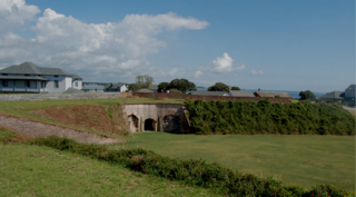
Located in North Carolina on the Atlantic Coast, the Fort Caswell Historic District encompasses 2 sites, 43 buildings, and 23 structures; it was added to the National Register of Historic Places in 2013. The fort itself was occupied by various branches of the U.S. armed forces for most of the period between 1836 and 1945 and is now a part of the North Carolina Baptist Assembly, a Christian retreat, owned and operated by the Baptist State Convention of North Carolina. It is accessible by the public to a limited extent per the conditions set forth by the Assembly’s Director.

The Oak Island Golf Club (OIGC) is located in Caswell Beach NC on the south side of Oak Island looking out at the Atlantic Ocean. Part of the Lower Cape Fear region in Brunswick County, Southeast North Carolina, it is one of the few 18 holes golf courses built on a barrier island. The privately owned 6,720 yard, par 72 course is open to the public and has 37 bunkers with water in play on 11 holes. Laid out with five sets of tees which present a wide range of playability, the back (blue) tees are course rated at 73.1 with a slope of 139. A pro shop/pub/snack bar along with a full practice facility to include a sand trap, both putting and pitching greens, and a driving range is also available to the public.

Coast Guard Station Oak Island referred to locally as the Oak Island Coast Guard Station (OICGS) is located in the Town of Caswell Beach on Oak Island in Brunswick County, North Carolina. A part of the Cape Fear region, the station is in the United States Coast Guard 5th District which is charged with ensuring the safety and security of the oceans, coastal areas, and marine transportation system within the Mid-Atlantic Region. The district encompasses some 156,000 square miles of ocean, bays, rivers, wetlands and tidal marshes, geographic waterways, several major mid-Atlantic ports, and the Nation’s capital. They also patrol the mouth of the Cape Fear River in Southport, North Carolina and the Intracoastal Waterway (ICW)


