Fort Charles (Jamaica)

Last updated

Fort Charles
Port Royal, Jamaica
Port Royal Fort defenses.JPG
King's battery at Fort Charles
Jamaica location map.svg
Red pog.svg
Fort Charles
Coordinates 17°56′06″N76°50′33″W / 17.935048°N 76.842475°W / 17.935048; -76.842475
Site information
OwnerGovernment of Jamaica
Open to
the public
Yes
Site history
Builtc. 1655
In useNo
Materials brick

Fort Charles was built between 1650 and 1660, the first fort constructed in Port Royal, Jamaica. [1]

Contents

Location

Fort Charles is located in the small town of Port Royal in Jamaica. The town was founded on a natural harbour and Fort Charles was constructed to guard its entrance. According to Donny L. Hamilton, the fort was situated at the tip of the sand spit separating Kingston Harbour from the Caribbean. [2] The fort is almost completely surrounded by water.

History

In 1654, Jamaica was under Spanish control and Spain was at war with England. Oliver Cromwell, Lord Protector of England, sent an expedition to invade the Spanish island Hispaniola. When the expedition failed, its leaders did not want to return home in shame. They turned their attention to capturing Jamaica, which was poorly defended. The buccaneer Henry Morgan was a member of the invading force led by William Penn and Venables. By May 1655, the English gained control of the island, and began construction of a fortified stronghold to defend their new acquisition. The fort was completed in 1655 and was the first of six forts to be built and manned by a garrison in Jamaica. It was initially referred to as Passage Fort [2] and after it was finished it was given the name "Fort Cromwell" in honour of the patron of the expedition and leader of the Commonwealth at the time. However, it received its present name after the restoration of the monarchy under Charles II. [1]

By 1667 it had 40 guns while in 1765 it had 104 guns and a garrison of 500 men. [1] It was damaged by both the 1692 Jamaica earthquake and the 1907 Kingston earthquake, which later resulted in the tilting of the Giddy House, now a minor tourist attraction.

The other fort guarding Kingston harbor is now the Fort Augusta Adult Correctional Centre

Scenery

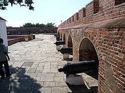
Fort Charles was built in the shape of a ship. According to Don Philpott, the fort is very well preserved with its rows of semi-circular gun ports. [3] Along every other row of the outer wall of the fort are cannons lined adjacently. According to Amitabh Sharma, “The red-bricked asymmetrical fortification once stood guard, warding off intruders and intimidating them with a battery of high calibre guns that were strategically mounted in the periphery”. [4]

The Fort today

Fort Charles Port Royal in Tranquility.jpg
Fort Charles

Today, Fort Charles is still standing tall. After the numerous hurricanes and earthquakes, the fort did undergo some natural changes. [5] The set up of the lined cannons on the outside wall is fairly the same. The only thing that differs from before the earthquake in 1692 is that there is now a museum located inside of the fort.

Related Research Articles

<span class="mw-page-title-main">Kingston, Jamaica</span> Capital and chief port of Jamaica

Kingston is the capital and largest city of Jamaica, located on the southeastern coast of the island. It faces a natural harbour protected by the Palisadoes, a long sand spit which connects the town of Port Royal and the Norman Manley International Airport to the rest of the island. Kingston is the largest predominantly English-speaking city in the Caribbean.

<span class="mw-page-title-main">Henry Morgan</span> Privateer and political office holder in Jamaica (1635–1688)

Sir Henry Morgan was a Welsh privateer, plantation owner, and, later, Lieutenant Governor of Jamaica. From his base in Port Royal, Jamaica, he raided settlements and shipping on the Spanish Main, becoming wealthy as he did so. With the prize money from the raids, he purchased three large sugar plantations on the island.

<span class="mw-page-title-main">Port Royal</span> City in Kingston, Jamaica

Port Royal is a town located at the end of the Palisadoes, at the mouth of Kingston Harbour, in southeastern Jamaica. Founded in 1494 by the Spanish, it was once the largest city in the Caribbean, functioning as the centre of shipping and commerce in the Caribbean Sea by the latter half of the 17th century. It was destroyed by an earthquake on 7 June 1692, which had an accompanying tsunami, leading to the establishment of Kingston, which is now the largest city in Jamaica. Severe hurricanes have regularly damaged the area. Another severe earthquake occurred in 1907.

<span class="mw-page-title-main">Martello tower</span> Small defensive fort

Martello towers, sometimes known simply as Martellos, are small defensive forts that were built across the British Empire during the 19th century, from the time of the French Revolutionary Wars onwards. Most were coastal forts.

<span class="mw-page-title-main">Spanish Town</span> Town in Middlesex, Jamaica

Spanish Town is the capital and the largest town in the parish of St. Catherine in the historic county of Middlesex, Jamaica. It was the Spanish and British capital of Jamaica from 1534 until 1872. The town is home to numerous memorials, the national archives, and one of the oldest Anglican churches outside England.

<span class="mw-page-title-main">Palisadoes</span>

Palisadoes is the thin tombolo of sand that serves as a natural protection for Kingston Harbour, Jamaica. Norman Manley International Airport and the historic town of Port Royal are both on Palisadoes.

<span class="mw-page-title-main">Anglo-Spanish War (1654–1660)</span> War between the English Protectorate, under Oliver Cromwell, and Spain

The Anglo-Spanish War was a conflict between the English Protectorate under Oliver Cromwell, and Spain, between 1654 and 1660. It was caused by commercial rivalry. Each side attacked the other's commercial and colonial interests in various ways such as privateering and naval expeditions. In 1655, an English amphibious expedition invaded Spanish territory in the Caribbean. In 1657, England formed an alliance with France, merging the Anglo–Spanish war with the larger Franco-Spanish War resulting in major land actions that took place in the Spanish Netherlands.

<span class="mw-page-title-main">Kingston Harbour</span> Harbour in Kingston, Jamaica

Kingston Harbour in Jamaica is the seventh-largest natural harbour in the world. It is an almost landlocked area of water approximately 16 kilometres (9.9 mi) long by 3.2 kilometres (2.0 mi) wide. Most of it is deep enough to accommodate large ships, even close to shore. It is bordered to the north by the city of Kingston, the capital of Jamaica; to the west by Hunts Bay and the municipality of Portmore; and to the south and east by the Palisadoes strip, which protects it.

Major General Robert Sedgwick was an English colonist, born 1611 in Woburn, Bedfordshire, England, and baptised on 6 May 1613.

<span class="mw-page-title-main">Siege of Havana</span> 1762 capture of Spanish-held Havana by the British during the Seven Years War

The siege of Havana was a successful British siege against Spanish-ruled Havana that lasted from March to August 1762, as part of the Seven Years' War. After Spain abandoned its former policy of neutrality by signing the family compact with France, resulting in a British declaration of war on Spain in January 1762, the British government decided to mount an attack on the important Spanish fortress and naval base of Havana, with the intention of weakening the Spanish presence in the Caribbean and improving the security of its own North American colonies. A strong British naval force consisting of squadrons from Britain and the West Indies, and the military force of British and American troops it convoyed, were able to approach Havana from a direction that neither the Spanish governor nor the Admiral expected and were able to trap the Spanish fleet in the Havana harbour and land its troops with relatively little resistance.

The history of the Jews in Jamaica predominantly dates back to migrants from Spain and Portugal. Starting in 1509, many Jews began fleeing from Spain because of the persecution of the Holy Inquisition. When the English captured Jamaica from Spain in 1655, the Jews who were living as conversos began to practice Judaism openly. By 1611, the Island of Jamaica had reached an estimated population of 1,500 people. An estimated 75 of those people were described as "foreigners," which may have included some Portuguese Jews. Still, many Jews faced persecution from English merchants.

<span class="mw-page-title-main">Siege of Saigon</span>

The siege of Saigon, a two-year siege of the city by the Vietnamese after its capture on February 17, 1859 by a Franco-Spanish flotilla under the command of the French admiral Charles Rigault de Genouilly, was one of the major events of the Conquest of Cochinchina (1858–62). Saigon was of great strategic importance, both as the key food-producing area of Vietnam and as the gateway to Cochinchina.

Fort Augusta Adult Correctional Centre, formerly Fort Augusta Prison, is Jamaica's only prison for women. It was built to accommodate 250 female inmates but has held over 280 on occasions. It has been known to run short of food. It is operated by the Department of Correctional Services for the Ministry of National Security.

The 1692 Jamaica earthquake struck Port Royal, Jamaica, on 7 June. A stopped pocket watch found in the harbor during a 1959 excavation indicated that it occurred around 11:43 AM local time.

The Battle of Rio Nuevo took place between 25 and 27 June 1658 on the island of Jamaica between Spanish forces under Cristóbal Arnaldo Isasi and English forces under governor Edward D'Oyley. In the battle lasting over two days the invading Spanish were routed. It is the largest battle to be fought on Jamaica.

<span class="mw-page-title-main">Invasion of Jamaica</span> 1655 invasion of Jamaica by the English

The Invasion of Jamaica took place in May 1655, during the 1654 to 1660 Anglo-Spanish War, when an English expeditionary force captured Spanish Jamaica. It was part of an ambitious plan by Oliver Cromwell to acquire new colonies in the Americas, known as the Western Design.

<span class="mw-page-title-main">Fort Haldane</span>

Fort Haldane is located near Port Maria in the parish of St Mary, Jamaica and was erected in 1759. It was named after General George Haldane, then Governor of Jamaica. The fort was constructed to protect the harbour of Port Maria from Spanish raids. It was also used as a garrison to keep the enslaved and working classes of St. Mary under control.

First built in 1880 near Fort Charles, Jamaica, Giddy House was originally a Royal Artillery House meant to store weapons and gunpowder for the adjacent Victoria and Albert Battery. After Port Royal was struck by an earthquake in 1907, Giddy House partially sank into the ground as a result of soil liquefaction. Its nickname, Giddy House, comes from the feeling visitors have when trying to stand straight while inside.

<span class="mw-page-title-main">Jamaica Station (Royal Navy)</span> Military unit

The Jamaica Station was a formation or command of the United Kingdom's Royal Navy stationed at Port Royal in Jamaica from 1655 to 1830.

<span class="mw-page-title-main">Rockfort (Jamaica)</span> Former site of 17th century British fort

Rockfort, located east of Kingston, Jamaica, in an area previously known as Harbour Head, is the ruins of a 17th century rock fort that was once surrounded by a moat. First the site of a British rock fort, it was fortified in 1694 to protect the eastern edge of Kingston against an invasion by the French. To thwart any eastward advance of the Morant Bay rebellion to Kingston, it was last staffed in 1865. The site that once protected Kingston Harbour is under the administration of the Jamaica National Heritage Trust.

References

  1. 1 2 3 "Fort Charles". Jamaica National Heritage Trust. Retrieved 24 October 2013.
  2. 1 2 3. Hamilton, Donny L. "Background History of Port Royal." Background History of Port Royal. Nautical Archaeology Program, Texas A&M University, 2000. Web. 03 May 2015.
  3. Philpott, Don (2000). Fort Charles. Jamaica, Ashbourne: Landmark.
  4. Sharma, Amitabh (24 November 2013). Port Royal: Fortified Heritage. Gleaner Company . Retrieved 21 April 2015.{{cite book}}: |newspaper= ignored (help)
  5. The Editors of Encyclopaedia Britannica (20 July 1998). "Port Royal". Encyclopædia Britannica . Encyclopædia Britannica, Inc. Retrieved 21 April 2015.