Its purpose was to facilitate trade with the Anishinaabe and to protect them against the raids of the Iroquois. The fort was built on a place of meeting and exchange used for a long time by the Atikamekw, Hurons, and other North Amerindian nations.
at the mouth of the Du Moine river, is another fort or trading post, where I found a small encampment of Maskegons Indians with whom I exchanged several articles for furs.[2]
Abandoned, the Fort Dumoine resumed its activities, thanks to the North West Company in 1784. The 1801 map by Alexander Mackenzie [4] indicates the course of the Du Moine river but does not go back to its source.
In 1811, it became the property of the Hudson's Bay Company and did not cease its activities until 1860 because of the logging companies which, by destroying wildlife habitats, almost destroyed the beavers. The site was completely flooded by Holden Lake, following the construction of the Des Joachims dam from 1946.
↑ Henry, Alexander, Travels and Adventures in Canada and the Indian Territories between the year 1760 and 1776, Toronto, Ed. Georges N. Morang & company ltd, 1910
↑ Dunn, Guillaume, Les forts de l'Outaouais, Éditions du Jour, 1975
Fort Dearborn was a United States fort built in 1803 beside the Chicago River, in what is now Chicago, Illinois. It was constructed by troops under Captain John Whistler and named in honor of Henry Dearborn, then United States Secretary of War. The original fort was destroyed following the Battle of Fort Dearborn during the War of 1812, and a second fort was constructed on the same site in 1816. By 1837, the fort had been de-commissioned.
The North West Company was a fur trading business headquartered in Montreal from 1779 to 1821. It competed with increasing success against the Hudson's Bay Company in what is present-day Western Canada and Northwestern Ontario. With great wealth at stake, tensions between the companies increased to the point where several minor armed skirmishes broke out, and the two companies were forced by the British government to merge.
Buckingham is a town located in the Outaouais region in the western portion of the province of Quebec, Canada. Since 1 January 2002, it has been part of the amalgamated city of Gatineau, which merged five former municipalities, including Masson-Angers, Buckingham, Hull, Aylmer and Gatineau, into a single entity. According to the 2016 Census, the population of the town was 16,685.
Fort William was a city in Ontario, Canada, located on the Kaministiquia River, at its entrance to Lake Superior. It amalgamated with Port Arthur and the townships of Neebing and McIntyre to form the city of Thunder Bay in January 1970. Since then it has been the largest city in Northwestern Ontario. The city's Latin motto was A posse ad esse, featured on its coat of arms designed in 1900 by town officials, "On one side of the shield stands an Indian dressed in the paint and feathers of the early days; on the other side is a French voyageur; the center contains an [grain] elevator, a steamship and a locomotive, while the beaver surmounts the whole."
Pontiac is a municipality in the Outaouais region of western Quebec, Canada, on the north shore of the Ottawa River. It is part of Les Collines-de-l'Outaouais Regional County Municipality, located within Canada's National Capital Region. It should not be confused with Pontiac Regional County Municipality, which borders Pontiac to the west.
The Illinois Country —sometimes referred to as Upper Louisiana —was a vast region of New France claimed in the 1600s in what is now the Midwestern United States. While these names generally referred to the entire Upper Mississippi River watershed, French colonial settlement was concentrated along the Mississippi and Illinois Rivers in what is now the U.S. states of Illinois and Missouri, with outposts in Indiana. Explored in 1673 from Green Bay to the Arkansas River by the Canadien expedition of Louis Jolliet and Jacques Marquette, the area was claimed by France. It was settled primarily from the Pays d'en Haut in the context of the fur trade, and in the establishment of missions by French Catholic religious orders. Over time, the fur trade took some French to the far reaches of the Rocky Mountains, especially along the branches of the broad Missouri River valley. The French name, Pays des Ilinois, means "Land of the Illinois [plural]" and is a reference to the Illinois Confederation, a group of related Algonquian native peoples.
York Factory was a settlement and Hudson's Bay Company (HBC) factory located on the southwestern shore of Hudson Bay in northeastern Manitoba, Canada, at the mouth of the Hayes River, approximately 200 kilometres (120 mi) south-southeast of Churchill. York Factory was one of the first fur-trading posts established by the HBC, built in 1684 and used in that business for more than 270 years. The settlement was headquarters of the HBC's Northern Department from 1821 to 1873. The complex was designated a National Historic Site of Canada in 1936.
Fort Ouiatenon, built in 1717, was the first fortified European settlement in what is now called Indiana. It was a palisade stockade with log blockhouse used as a French trading post on the Wabash River located approximately three miles southwest of modern-day West Lafayette. The name 'Ouiatenon' is a French rendering of the name in the Wea language, waayaahtanonki, meaning 'place of the whirlpool'. It was one of three French forts built during the 18th century in what was then New France, later the Northwest Territory and today the state of Indiana, the other two being Fort Miami and Fort Vincennes. A substantial French settlement grew up around the fort in the mid-18th century. It was ceded to the British and abandoned after the French and Indian war. Later, it passed into Indian hands and was destroyed in 1791 by American militia during the Northwest Indian War. It was never a U.S. fort. The original site was rediscovered in the 1960s; the archaeological site was listed on the National Register of Historical Places in 1970, and was designated a National Historic Landmark in 2021.
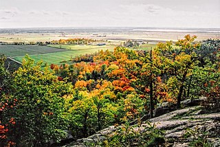
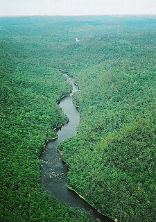
The Dumoine River is a river in western Quebec with its source in Machin Lake near La Vérendrye Wildlife Reserve. From Dumoine Lake, the river flows almost due south off the Canadian Shield and empties into the Ottawa River, just west of Rapides-des-Joachims, Quebec, or Rolphton, Ontario. The river is 129 kilometres (80 mi) long and drains a watershed of 5,380 square kilometres (2,080 sq mi). This relatively short river compared to its drainage area indicates that the Dumoine has a strong current and many steep-gradient rapids.
The Sagkeeng First Nation is a Treaty-1 First Nation in the Eastman Region of Manitoba, Canada, that is composed of the Anishinaabe people indigenous to the area at or near the Fort Alexander Indian Reserve #3 located along the Winnipeg River and Traverse Bay. Today, Sagkeeng holds territory in the southern part of Lake Winnipeg, 120 kilometres (75 mi) north of the city of Winnipeg, and on the mainland.
Fort Espérance was a North West Company trading post near Rocanville, Saskatchewan from 1787 until 1819. It was moved three times and was called Fort John from 1814 to 1816. There was a competing XY Company post from 1801 to 1805 and a Hudson's Bay post nearby from 1813 to 1816. It was on the Qu'Appelle River about 20 km from that river's junction with the Assiniboine River and about 7 km west of the Manitoba border. It was on the prairie in buffalo country and was mainly used as a source of pemmican which was sent down the river to Fort Bas de la Rivière at the mouth of the Winnipeg River.
The Coulonge River is a predominantly wilderness river in western Quebec, Canada. One of a dozen or so significant tributaries of the Ottawa River, it has a length of 240 kilometres (150 mi) and a drainage area of 5,060 square kilometres (1,950 sq mi), and runs in a general south-eastern direction from its headwaters in Lac au Barrage to the Ottawa River at Fort-Coulonge. Over that distance, it drops approximately 260 meters (850 ft) — 48 meters (157 ft) of that over the massive Grandes or Coulonge Chutes, approximately 15 kilometers (9.3 mi) upstream of the confluence with the Ottawa River.
Rapides-des-Joachims is a municipality and village in western Quebec, Canada, part of Pontiac County in the Outaouais region. The village is situated on Rapides-des-Joachims Island on the Ottawa River, about 100 km northwest of Fort-Coulonge. It is also known as Swisha.
Portage-du-Fort is a village municipality in the Pontiac Regional County Municipality in the southwest corner of the Outaouais region of Quebec, Canada. The village lies across the Ottawa River from Chenaux, Ontario and Horton, Ontario.
Sheenboro is a village and municipality in the Outaouais region, part of the Pontiac Regional County Municipality, Quebec, Canada. It was formerly known as Sheen-Esher-Aberdeen-et-Malakoff. Its territory stretches along the north shore of the Ottawa River from Chichester to Rapides-des-Joachims.
Bas de la Rivière is a geographical area on both sides of the Winnipeg River at and near the mouth where it empties into Lake Winnipeg. It had a storied historical period in the opening of the west and the subsequent fur trade and settlement.
Saskatchewan River fur trade The Saskatchewan River was one of the two main axes of Canadian expansion west of Lake Winnipeg. The other and more important one was northwest to the Athabasca Country. For background see Canadian canoe routes (early). The main trade route followed the North Saskatchewan River and Saskatchewan River, which were just south of the forested beaver country. The South Saskatchewan River was a prairie river with few furs.
Fur trading on the Assiniboine River and the general area west of Lake Winnipeg began as early as 1731.
The zec Dumoine is a controlled harvesting zone located in the unorganized territory of Les Lacs-du-Témiscamingue, in the MRC Témiscamingue Regional County Municipality, in the administrative region of Abitibi-Témiscamingue, in Quebec, in Canada.
Michipicoten Provincial Park is a park in Ontario, Canada, located at the mouth of the Michipicoten River. The park preserves the ruins of a French trading post that operated from the early 1700s until it was abandoned by the Hudson’s Bay Company in 1904.
This page is based on this Wikipedia article Text is available under the CC BY-SA 4.0 license; additional terms may apply. Images, videos and audio are available under their respective licenses.