Fort Frederick, United States Virgin Islands | |
|---|---|
Village | |
| Country | |
| Island | Saint Croix |
| Time zone | UTC-4 (AST) |
Fort Frederick is a settlement on the island of Saint Croix in the United States Virgin Islands.
Fort Frederick, United States Virgin Islands | |
|---|---|
Village | |
| Country | |
| Island | Saint Croix |
| Time zone | UTC-4 (AST) |
Fort Frederick is a settlement on the island of Saint Croix in the United States Virgin Islands.

Olga is an unincorporated community and census-designated place (CDP) in Lee County, Florida, United States. The population was 1,952 at the 2010 census, up from 1,398 at the 2000 census. It is part of the Cape Coral-Fort Myers, Florida Metropolitan Statistical Area.
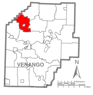
Jackson Township is a township in Venango County, Pennsylvania, United States. The population was 1,168 at the 2000 census.

Pantego is a town in Tarrant County, Texas, United States. The population was 2,394 at the 2010 census. It is entirely surrounded by the cities of Arlington and Dalworthington Gardens. It is in the middle of the Dallas–Fort Worth metroplex, a metropolitan area spanning several counties.

Cruz Bay, U.S. Virgin Islands is the main town on the island of Saint John in the United States Virgin Islands. According to the 2000 census, Cruz Bay had a population of 2,743.
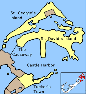
Coney Island is part of the chain which makes up Bermuda. It is located in St. George's Parish, in the northeast of the territory.

The St. Joseph Peninsula is located in Gulf County, Florida, in the Florida Panhandle, at coordinates 29°42′55″N85°23′05″W. It is a 15-mile long spit, extending northward from Cape San Blas between the Gulf of Mexico to the west and St. Joseph Bay to the east. It is 6 miles west of Port St. Joe at its closest point. The peninsula is also known as St. Joseph Spit. The northern end of the peninsula is known as St. Joseph Point.
Fort Purcell is a ruined fort near Pockwood Pond on the island of Tortola in the British Virgin Islands.
Fort Charlotte is a fort built on Harrigan's Hill, Tortola, British Virgin Islands. The fort was named after Charlotte of Mecklenburg-Strelitz, who was the wife of King George III.

Fort Burt is a colonial fort that was erected on the southwest edge of Road Town, Tortola in the British Virgin Islands above Road Reef Marina. The site is now a hotel and restaurant of the same name, and relatively little of the original structure remains. However, one of the original cannons has survived and stands on the veranda of the hotel, vigilantly looking over the harbour.

Fort George is a colonial fort which was erected on the northeast edge of Road Town, Tortola in the British Virgin Islands above Baugher's Bay. The site is now a ruin.
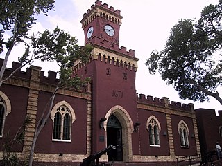
Fort Christian is a Dano-Norwegian-built fort in Charlotte Amalie, Saint Thomas, U.S. Virgin Islands. Built 1672-1680, early in the first successful colonial establishment on the island, the fort served as a critical point of defense and government during the entire period of Dano-Norwegian, and later Danish, administration, which ended in 1917 with the sale of the islands to the United States. It currently holds the St. Thomas Museum, which holds artifacts and art of the Dano-Norwegian period. It was designated a U.S. National Historic Landmark in 1977.

Fort Recovery is a fort on the West End of Tortola in the British Virgin Islands. In historical records, the fort is often referred to as Tower Fort, and the area around the fort is still referred to as "Towers" today. A hotel is now built around the Tower.

Road Town Fort is a colonial fort which was erected on Russell Hill in Road Town, Tortola in the British Virgin Islands above the town's main wharf. In historical records it is sometimes referred to as Fort Road Town. The fort subsequently fell into ruin, and in the 1960s the Bougainvillea clinic was built on top of the old structure. The strong room of the original fort, which was once the Territory's treasury, still survives today, and is now used as a storeroom by the clinic.

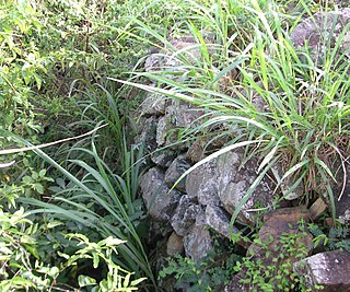
The Whelk Point Fort was a colonial fort erected on the southeast part of Tortola in the British Virgin Islands. The fort fell into disrepair and ruin, and relatively little of the original structure remains. In 1992 a house was built over the original foundations of the fort, but the remains of the barracks can still be seen on the land behind the house. The ruins are on private property and are not generally accessible to the public.

Lamoureux is a hamlet in central Alberta, Canada within Sturgeon County. It is located 6 kilometres (3.7 mi) northeast of Edmonton's city limits on the northern shore of the North Saskatchewan River, opposite the City of Fort Saskatchewan.

The Dutch Virgin Islands is the collective name for the enclaves that the Dutch West India Company had in the Virgin Islands. The area was ruled by a director, whose seat was not permanent. The main reason for starting a colony here was that it lay strategically between the Dutch colonies in the south and New Netherland. The Dutch West India Company was mainly affected by the competition from Denmark, England and Spain. In 1680 the remaining islands became a British colony.
Fort Christian is a settlement on the island of Saint Thomas in the United States Virgin Islands.
Upper Bethlehem is a settlement on the island of Saint Croix in the United States Virgin Islands.

The Creque Marine Railway, formerly the "St Thomas Marine Repair Facility", is an inclined-plane ship railway on Hassel Island, in the bay of Charlotte Amalie off the coast of St. Thomas Island, in the U.S. Virgin Islands. Its site is below Fort Shipley, within Virgin Islands National Park.
Coordinates: 17°42′55″N64°52′59″W / 17.71528°N 64.88306°W
| | This Saint Croix, United States Virgin Islands location article is a stub. You can help Wikipedia by expanding it. |