Lake Champlain is a natural freshwater lake in North America mainly within the borders of the United States but partially situated across the Canada–U.S. border, in the Canadian province of Quebec.
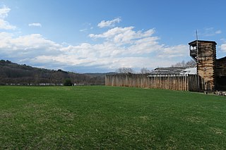
Fort Ticonderoga, formerly Fort Carillon, is a large 18th-century star fort built by the French at a narrows near the south end of Lake Champlain, in northern New York, in the United States. It was constructed by Canadian-born French military engineer Michel Chartier de Lotbinière, Marquis de Lotbinière between October 1755 and 1757, during the action in the "North American theater" of the Seven Years' War, often referred to in the US as the French and Indian War. The fort was of strategic importance during the 18th-century colonial conflicts between Great Britain and France, and again played an important role during the American Revolutionary War.

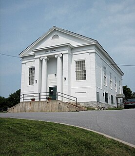
Washington County is a county in the U.S. state of New York. As of the 2010 census, the population was 63,216. The county seat is Fort Edward. The county was named for U.S. President George Washington.

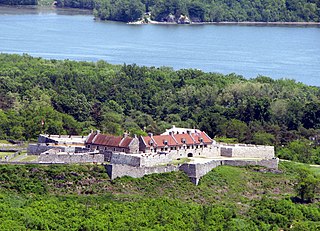
Crown Point is a town in Essex County, New York, United States, located on the west shore of Lake Champlain. The population was 2,024 at the 2010 census. The name of the town is a direct translation of the original French name, "Pointe à la Chevelure".

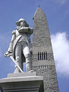
John Stark was a New Hampshire native who served as an officer in the British Army during the French and Indian war and a major general in the Continental Army during the American Revolution. He became widely known as the "Hero of Bennington" for his exemplary service at the Battle of Bennington in 1777.

Fort Oswego was an 18th-century trading post in the Great Lakes region in North America, which became the site of a battle between French and British forces in 1756 during the French and Indian War. The fort was established in 1727 on the orders of New York governor William Burnet, adjacent to a 1722 blockhouse that had originally been a way station for French traders. The log palisade fort established a British presence on the Great Lakes.
The 1777 Siege of Fort Ticonderoga occurred between 2 and 6 July 1777 at Fort Ticonderoga, near the southern end of Lake Champlain in the state of New York. Lieutenant General John Burgoyne's 8,000-man army occupied high ground above the fort, and nearly surrounded the defenses. These movements precipitated the occupying Continental Army, an under-strength force of 3,000 under the command of General Arthur St. Clair, to withdraw from Ticonderoga and the surrounding defenses. Some gunfire was exchanged, and there were some casualties, but there was no formal siege and no pitched battle. Burgoyne's army occupied Fort Ticonderoga and Mount Independence, the extensive fortifications on the Vermont side of the lake, without opposition on 6 July. Advance units pursued the retreating Americans.

Fort Clinton was an American Revolutionary War fort erected by the Continental Army on the west bank of the Hudson River in 1776.
Seth Warner was a Revolutionary War officer from Vermont who rose to rank of Continental colonel and was often given the duties of a brigade commander. He is best known for his leadership in the capture of Fort Crown Point, the Battle of Longueuil, the siege of Quebec, the retreat from Canada, and the battles of Hubbardton and Bennington.
Chimney Point is a peninsula in the town of Addison, Vermont, which juts into Lake Champlain forming a narrows. It is one of the earliest settled and most strategic sites in the Champlain Valley.
The Fort at Number 4 was a fortification protecting Plantation Number 4, the northernmost British settlement along the Connecticut River in New Hampshire until after the French and Indian War. Number 4 was one of 32 towns established on the same day through the Massachusetts Bay Colony. Now known as Charlestown, Plantation Number 4 was more than 30 miles (50 km) from the nearest other British settlement at Fort Dummer. Settlement of the town began in 1740 by brothers Stephen, Samuel and David Farnsworth. By 1743, there were 10 families settled at Number 4.
The Catamount Tavern was a tavern in Old Bennington, Vermont, United States. Originally known as Fay’s House, it is marked now by a granite and copper statue placed in 1896. It was built 1769 and burned in 1871. During the tavern's 102 years of existence, it was the site of many important events in Vermont's colonial and revolutionary history.

Fort Independence is a granite bastion fort that provided harbor defenses for Boston, Massachusetts. Located on Castle Island, Fort Independence is one of the oldest continuously fortified sites of English origin in the United States. The first primitive fortification, called "The Castle", was placed on the site in 1634 and, after two re-buildings, replaced circa 1692 with a more substantial structure known as Castle William. Re-built after it was abandoned by the British during the American Revolution, Castle William was renamed Fort Adams and then Fort Independence. The existing granite fort was constructed between 1833 and 1851. Today it is preserved as a state park and fires occasional ceremonial salutes. Fort Independence was added to the National Register of Historic Places in 1970.

Mount Defiance is an 853 ft (260 m) high hill on the New York side of Lake Champlain, in the northeastern United States. It is notable in that the hill militarily dominates both Fort Ticonderoga and Mount Independence, but it was deemed inaccessible so never fortified. Mount Defiance was previously known as Sugar Loaf.
Fort Montgomery on Lake Champlain is the second of two American forts built at the northernmost point of the American part of the lake: a first, unnamed fort built on the same site in 1816 and Fort Montgomery built in 1844.

Blockhouse No. 1, colloquially known as The Blockhouse, is a small fort in the northern part of Central Park, in Manhattan, New York City, and is the second oldest structure in the park, aside from Cleopatra's Needle. It is located on an overlook of Manhattan schist, with a clear view of the flat surrounding areas north of Central Park. Finished in 1814, the fort was part of a series of fortifications in northern Manhattan, which originally also included three fortifications in what was then called Harlem Heights, now known as Morningside Heights. The fort is the last remaining fortification from these defenses. Frederick Law Olmsted and Calvert Vaux, the designers of Central Park, treated Blockhouse No. 1 as a picturesque ruin, romantically overrun with vines and Alpine shrubbery.

McGowan's Pass is a topographical feature of Central Park in New York City, just west of Fifth Avenue and north of 102nd Street. It has been incorporated into the park's East Drive since the early 1860s. A steep hill descending into a switchback road, it is a popular training route for competitive bicyclists and runners.

The Hubbardton Military Road was originally a trail cut through the wilderness of western Vermont, during the American Revolutionary War to connect fortifications on Lake Champlain with existing roads and frontier settlements, so that the Continental Army could be reinforced and supplied.