The Trail of Tears was an ethnic cleansing and forced displacement of approximately 60,000 people of the "Five Civilized Tribes" between 1830 and 1850 by the United States government. As part of the Indian removal, members of the Cherokee, Muscogee (Creek), Seminole, Chickasaw, and Choctaw nations were forcibly removed from their ancestral homelands in the Southeastern United States to newly designated Indian Territory west of the Mississippi River after the passage of the Indian Removal Act in 1830. The Cherokee removal in 1838 was brought on by the discovery of gold near Dahlonega, Georgia, in 1828, resulting in the Georgia Gold Rush.
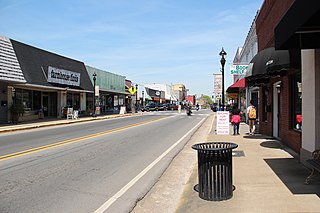
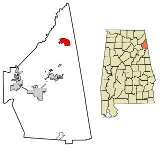
Fort Payne is a city in and county seat of DeKalb County, in northeastern Alabama, United States. At the 2020 census, the population was 14,877.

Elias Boudinot, also known as Buck Watie) was a writer, newspaper editor, and leader of the Cherokee Nation. He was a member of a prominent family, and was born and grew up in Cherokee territory, now part of present-day Georgia. Born to parents of mixed Cherokee and European ancestry and educated at the Foreign Mission School in Connecticut, he became one of several leaders who believed that acculturation was critical to Cherokee survival. He was influential in the period of removal to Indian Territory.

The Treaty of New Echota was a treaty signed on December 29, 1835, in New Echota, Georgia, by officials of the United States government and representatives of a minority Cherokee political faction, the Treaty Party.

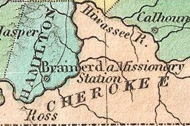
New Echota was the capital of the Cherokee Nation in the Southeast United States from 1825 until their forced removal in the late 1830s. New Echota is located in present-day Gordon County, in northwest Georgia, 3.68 miles north of Calhoun. It is south of Resaca, next to present day New Town, known to the Cherokee as Ꭴꮝꮤꮎꮅ, Ustanali. The site has been preserved as a state park and a historic site. It was designated in 1973 as a National Historic Landmark District.

John Ridge, born Skah-tle-loh-skee, was from a prominent family of the Cherokee Nation, then located in present-day Georgia. He went to Cornwall, Connecticut, to study at the Foreign Mission School. He met Sarah Bird Northup, of a New England Yankee family, and they married in 1824. Soon after their return to New Echota in 1825, Ridge was chosen for the Cherokee National Council and became a leader in the tribe.
Willstown was an important Cherokee town of the late 18th and early 19th century, located in the southwesternmost part of the Cherokee Nation, in what is now DeKalb County, Alabama. It was near Lookout or Little Wills Creek.
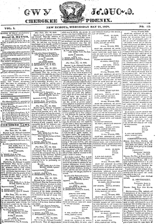
The Cherokee Phoenix is the first newspaper published by Native Americans in the United States and the first published in a Native American language. The first issue was published in English and Cherokee on February 21, 1828, in New Echota, capital of the Cherokee Nation. The paper continued until 1834. The Cherokee Phoenix was revived in the 20th century, and today it publishes both print and Internet versions.
Fort Cass was a fort located on the Hiwassee River in present-day Charleston, Tennessee, that served as the military operational headquarters for the entire Cherokee removal, an forced migration of the Cherokee known as the Trail of Tears from their ancestral homelands in the Southeast to Indian Territory in present-day Oklahoma. Fort Cass housed a garrison of United States troops who watched over the largest concentration of internment camps where Cherokee were kept during the summer of 1838 before starting the main trek west to Indian Territory, and served as one of three emigration deports where the Cherokee began their journey west, the others of which were located at Ross's Landing in Chattanooga and Gunter's Landing near Guntersville, Alabama.

Bellefonte is a ghost town in Jackson County, Alabama, United States, near the site of the Bellefonte Nuclear Generating Station. It is located roughly two miles southeast of Hollywood, Alabama.

Red Clay State Historic Park is a state park located in southern Bradley County, Tennessee, United States. The park was the site of the last capital of the Cherokee Nation in the eastern United States from 1832 to 1838 before the enforcement of the Indian Removal Act of 1830. This resulted in a forced migration of most of the Cherokee people to present-day Oklahoma known as the Cherokee removal. The site is considered sacred to the Cherokees, and includes the Blue Hole Spring, a large hydrological spring. It is also listed as an interpretive center along the Trail of Tears National Historic Trail.

Blythe Ferry was a ferry across the Tennessee River in Meigs County, Tennessee, United States. In 1838, the ferry served as a gathering point and crossing for the Cherokee Removal, commonly called the Trail of Tears, in which thousands of Cherokee were forced to move west to Oklahoma from their homeland in the southeastern United States.
Broomtown is an unincorporated community and census-designated place in Cherokee County, Alabama, United States. As of the 2010 census, its population was 182.

Cherokee history is the written and oral lore, traditions, and historical record maintained by the living Cherokee people and their ancestors. In the 21st century, leaders of the Cherokee people define themselves as those persons enrolled in one of the three federally recognized Cherokee tribes: The Eastern Band of Cherokee Indians, The Cherokee Nation, and The United Keetoowah Band of Cherokee Indians.

The Cherokee Nation was a legal, autonomous, tribal government in North America recognized from 1794 to 1907. It was often referred to simply as "The Nation" by its inhabitants. The government was effectively disbanded in 1907, after its land rights had been extinguished, prior to the admission of Oklahoma as a state. During the late 20th century, the Cherokee people reorganized, instituting a government with sovereign jurisdiction known as the Cherokee Nation. On July 9, 2020, the United States Supreme Court ruled that the Muscogee (Creek) Nation had never been disestablished in the years before allotment and Oklahoma Statehood.
Cherokee removal, part of the Trail of Tears, refers to the forced relocation between 1836 and 1839 of an estimated 16,000 members of the Cherokee Nation and 1,000–2,000 of their slaves; from their lands in Georgia, South Carolina, North Carolina, Tennessee, and Alabama to the Indian Territory in the then Western United States, and the resultant deaths along the way and at the end of the movement of an estimated 4,000 Cherokee and unknown number of slaves, although no records of these deaths have ever materialized. Many scholars believe these Indians absconded from the removal rather than died.

The Echota Cherokee Tribe of Alabama is a state-recognized tribe in Alabama and Cherokee heritage group. It is based in northern Alabama and gained state-recognition under the Davis-Strong Act in 1984.

Cherokee Plantation is a historic house in Fort Payne, Alabama. The house was built in 1790 as a two-story log cabin by Andrew Ross, a judge on the Cherokee Supreme Court and brother of Principal Chief John Ross. In 1834 a second log cabin was built connected to the rear of the original cabin, and a third was built to the northeast, separated by a breezeway. Ross, being one-eighth Cherokee, was forced to leave his home in 1838 under the provisions of the Treaty of New Echota, of which Ross was a signatory; a portion of the Cherokee Trail of Tears passes in front of the house.
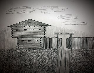
Fort Gardiner was a stockaded fortification with two blockhouses that was built in 1837 by the United States Army. It was one of the military outposts created during the Second Seminole War to assist Colonel Zachary Taylor's troops to capture Seminole Indians and their allies in the central part of the Florida Territory that were resisting forced removal to federal territory west of the Mississippi River per the Indian Removal Act.

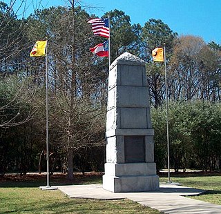
Fort Armstrong was a stockade fort built in present-day Cherokee County, Alabama during the Creek War. The fort was built to protect the surrounding area from attacks by Red Stick warriors but was also used as a staging area and supply depot in preparation for further military action against the Red Sticks.

