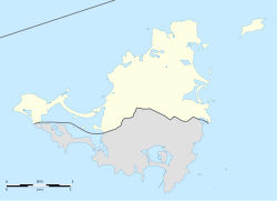
Fort Louis | |
---|---|
Marigot, Saint Martin | |
Coordinates | 18°04′15″N63°05′07″W / 18.070774°N 63.085404°W |
Type | Fortification |
Site information | |
Open to the public | Yes |
Condition | Ruins |
Site history | |
Built | 1789 |
In use | No |
Materials | Stone |
Fort Louis (or Fort St. Louis) [1] [2] is a historic French military fort on the Caribbean island of Saint Martin. It is located in Marigot, the capital of the French side of the island, overlooking Marigot Bay. [3] The fort was built in the 18th century to defend Marigot's harbor and its warehouses. [4] It was built during the reign of King Louis XVI.
By 1765, batteries of canons were set up in three locations to defend Marigot's harbor: on the cliff of Pointe Bluff (pointe de Bluff), on Round Hill (Morne Rond), and on Marigot Hill (Morne de Marigot). [5] A 1775 report written by Auguste Descoudrelles, [5] commander of Saint Martin and Saint Barthélemy at that time, said that a fort on Marigot Hill would have helped Saint Martin defend its port, [6] as the island had been prone to raids by the English. [7]
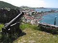
In 1789, Jean-Sébastien de Durat, subsequent commander of Saint Martin and Saint Barthélemy, oversaw the construction of a fort, a prison, and a bridge in Marigot, [5] under the orders of King Louis the XVI. The fort was built at the location of the Marigot Hill battery. Its purpose was to defend the warehouses in Marigot's harbor below, where local crops (such as coffee, salt, rum, and cane sugar) were stored. [4] [5] Durat named the fort Fort Louis, [5] likely after Louis XVI, the French king he served under.
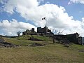
Originally Fort Louis was a wooden fort. [8] By the beginning of the 19th century, the fort extended down the slopes of Marigot Hill with the construction of two additional batteries. [8] While the fort was active, it had barracks for 54 troops. [1] It had a guard room, a kitchen, and cistern. [1]
It is possible that the fort was occupied by English troops while the English occupied the island of Saint Martin in 1781-1783, 1794, 1800 and 1810-1815. [8] [9] However, no evidence of English occupation of the fort has been found. [8]
In 1851, the fort was abandoned and decommissioned by the military. [1]
Between 1993 and 1994, restoration and enhancement work was undertaken by the Hope Estate Archaeological Association of Saint Martin (L'Association Archeologique Hope Estate), in cooperation the Military Service of Guadeloupe as well as the Departmental Archives in Basse-Terre, the National Overseas Archives in Aix-en-Provence. [5] [6]
Saint Martin is an island in the northeast Caribbean, approximately 300 km (190 mi) east of Puerto Rico. The 87-square-kilometre (34 sq mi) island is divided roughly 60:40 between the French Republic and the Kingdom of the Netherlands, but the Dutch part is more populated than the French part. The division dates to 1648. The northern French part comprises the Collectivity of Saint Martin and is an overseas collectivity of the French Republic. The southern Dutch part comprises Sint Maarten and is one of four constituent countries that form the Kingdom of the Netherlands. Even though the island is an overseas possession of two European Union member states, only the French part of the island is part of the EU.
The French West Indies or French Antilles are the parts of France located in the Antilles islands of the Caribbean:
Princess Juliana International Airport is the main airport on the Caribbean island of Saint Martin. The airport is located on the Dutch side of the island, in the country of Sint Maarten, close to the shore of Simpson Bay Lagoon. In 2015, the airport handled 1,829,543 passengers and around 60,000 aircraft movements. The airport serves as a hub for Winair and is the major gateway for the smaller Leeward Islands, including Anguilla, Saba, Saint Barthélemy and Sint Eustatius. It is named after Queen Juliana of the Netherlands, who landed there while she was heir presumptive in 1944, the year after the airport opened. The airport has very low-altitude flyover landing approaches because one end of its runway is extremely close to the shore and Maho Beach. While Princess Juliana International is the primary aviation gateway to the island, there is also a smaller public-use airport on the French side, in the French Collectivity of Saint Martin, called Grand Case-Espérance Airport.
"O Sweet Saint Martin's Land", also known by its French title, "Saint-Martin, si jolie", is the bi-national song of Saint-Martin / Sint Maarten island, an island divided between the French Republic and the Kingdom of the Netherlands. It was written in English by Gerard Kemps in 1958. Kemps also wrote and composed a French version with its own lyrics and a different tune.
Marigot is the main town and capital in the French Collectivity of Saint Martin.
The Collectivity of Saint Martin, commonly known as simply Saint Martin, is an overseas collectivity of France in the West Indies in the Caribbean, on the northern half of the island of Saint Martin, as well as some smaller adjacent islands. Saint Martin is separated from the island of Anguilla by the Anguilla Channel. Its capital is Marigot.
Sint Maarten is a constituent country of the Kingdom of the Netherlands in the Caribbean region of North America. With a population of 41,486 as of January 2019 on an area of 34 km2 (13 sq mi), it encompasses the southern 44% of the divided island of Saint Martin, while the northern 56% of the island constitutes the French overseas collectivity of Saint Martin. Sint Maarten's capital is Philipsburg. Collectively, Sint Maarten and the other Dutch islands in the Caribbean are often called the Dutch Caribbean.
Simpson Bay Lagoon is one of the largest inland lagoons in the West Indies of the Caribbean. It is located on the island of Saint Martin. The border between the French and Dutch halves of the island runs across the centre of the lagoon. There are two small islands that lie in the lagoon: the larger, Grand Ilet to the north, is within the French region of Saint-Martin; the smaller, Little Key, to the south, is on the Dutch Sint Maarten side.
The following outline is provided as an overview of and topical guide to the Collectivity of Saint Martin:
Air Martinique was an airline based in the island of Martinique in the Lesser Antilles in the Caribbean. Its head office was on the grounds of Fort-de-France Airport, now Martinique Aimé Césaire International Airport, in Le Lamentin.
Articles related to the French overseas department of Martinique include:
The following is an alphabetical list of topics related to the French overseas collectivity of Saint Martin.
A common visa exists since the end of 2010 for the territories of Aruba, Curaçao, Sint Maarten and the Caribbean Netherlands which form together the territory of the Kingdom of the Netherlands in the Caribbean. The visa is not valid for the European part of the Netherlands, which is part of the Schengen Area.
Saint Barthélemy, officially the Collectivité territoriale de Saint-Barthélemy, also known as St. Barts (English) or St. Barth (French), is an overseas collectivity of France in the Caribbean. The island lies about 30 kilometres (19 mi) southeast of the island of Saint Martin; it is northeast of the Dutch islands of Saba and Sint Eustatius, as well as north of the independent country of Saint Kitts and Nevis.
The Attack on Saint Martin was a failed attempt by the Dutch Republic to recapture the island and former base of the Dutch West India Company (WIC) from the Spanish. In 1633 the Spanish had invaded Saint-Martin and Anguilla, driving off the French and Dutch inhabitants. The French and Dutch banded together to repel the Spanish and it was during a 1644 sea battle that the Dutch commander Peter Stuyvesant, later the governor of New Amsterdam, unsuccessfully besieged Fort Amsterdam and was forced to retreat with the loss of hundreds of men. A stray Spanish cannonball shattered his leg, which had to be amputated. But luck was on the Dutch side, and when the Eighty Years' War between Spain and the Netherlands ended, the Spanish no longer needed a Caribbean base and just sailed away in 1648.
The economy of Saint Martin, divided between the French Collectivity of Saint Martin and the Dutch Sint Maarten, is predominately dependent on tourism. For more than two centuries, the main commodity exports have generally been salt and locally grown commodities, like sugar.
Mary Star of the Sea Church or Grand Case Catholic Church is a religious building affiliated to the Catholic Church located in Grand Case in the territorial collectivity of Saint Martin, a dependent territory of France that consists of the north half of the island of Saint Martin in the lesser Antilles. It should not be confused with the catholic church of the same name but located in the Dutch sector of the island.
The Saint Martin–Sint Maarten border, or France–Netherlands border, is the border between the Collectivity of Saint Martin, an overseas collectivity of France, and Sint Maarten, a constituent country of the Kingdom of the Netherlands, on the island of Saint Martin in the Caribbean. The 87-square-kilometre (34 sq mi) island is divided roughly 60:40 between the French Republic and the Kingdom of the Netherlands by the 16 km (10 mi) border. However, the two parts are roughly equal in population.
Ruby Bute is a painter, storyteller, and writer of the island of Saint Martin. She became the first woman to publish a book in Saint Martin with her poetry collection Golden Voices of S'maatin in 1989. Bute has been referred to as "the first dame of St. Martin’s cultural arts."