
The French and Indian War (1754–1763) pitted the colonies of British America against those of New France, each side supported by military units from the parent country and by Native American allies. At the start of the war, the French colonies had a population of roughly 60,000 settlers, compared with 2 million in the British colonies. The outnumbered French particularly depended on the natives.

The Northwest Territory, also known as the Old Northwest and formally known as the Territory Northwest of the River Ohio, was formed in the United States after the American Revolutionary War. Established in 1787 by the Congress of the Confederation through the Northwest Ordinance, it was the nation's first post-colonial organized incorporated territory.

Pontiac's War, also known as Pontiac's Conspiracy or Pontiac's Rebellion, was launched in 1763 by a loose confederation of American Indian tribes, primarily from the Great Lakes region, the Illinois Country, and Ohio Country who were dissatisfied with British policies in the Great Lakes region following the French and Indian War (1754–1763). Warriors from numerous tribes joined the uprising in an effort to drive British soldiers and settlers out of the region. The war is named after Odawa leader Pontiac, the most prominent of many Indian leaders in the conflict.

The Illinois Country — sometimes referred to as Upper Louisiana — was a vast region of New France claimed in the 1600s in what is now the Midwestern United States. While these names generally referred to the entire Upper Mississippi River watershed, French colonial settlement was concentrated along the Mississippi and Illinois Rivers in what is now the U.S. states of Illinois and Missouri, with outposts in Indiana. Explored in 1673 from Green Bay to the Arkansas River by the Canadien expedition of Louis Jolliet and Jacques Marquette, the area was claimed by France. It was settled primarily from the Pays d'en Haut in the context of the fur trade. Over time, the fur trade took some French to the far reaches of the Rocky Mountains, especially along the branches of the broad Missouri River valley. The French name, Pays des Ilinois, means "Land of the Illinois [plural]" and is a reference to the Illinois Confederation, a group of related Algonquian native peoples.

Fort Ouiatenon, built in 1717, was the first fortified European settlement in what is now called Indiana. It was a palisade stockade with log blockhouse used as a French trading post on the Wabash River located approximately three miles southwest of modern-day West Lafayette. The name 'Ouiatenon' is a French rendering of the name in the Wea language, waayaahtanonki, meaning 'place of the whirlpool'. It was one of three French forts built during the 18th century in what was then New France, later the Northwest Territory and today the state of Indiana, the other two being Fort Miami and Fort Vincennes. A substantial French settlement grew up around the fort in the mid-18th century. It was ceded to the British and abandoned after the French and Indian war. Later, it passed into Indian hands and was destroyed in 1791 by American militia during the Northwest Indian War. It was never a U.S. fort. The original site was rediscovered in the 1960s and is now an archaeological site on the National Register of Historical Places.
The Northwest Indian War (1785–1795), also known as the Ohio War, Little Turtle's War, and by other names, was a war between the United States and the Western Confederacy, with support from the British, for control of the Northwest Territory. It followed centuries of conflict over this territory, first among Native American tribes, and then with the added shifting alliances among the tribes and the European powers of France and Great Britain, and their colonials. The United States Army considers it their first of the United States Indian Wars.

Fort Saint Joseph was a fort established on land granted to the Jesuits by King Louis XIV; it was located on what is now the south side of the present-day town of Niles, Michigan. Père Claude-Jean Allouez established the Mission de Saint-Joseph in the 1680s. Allouez ministered to the local Native Americans, who were primarily Odawa and Ojibwe.

The Western theater of the American Revolutionary War (1775–1783) was the area of conflict west of the Appalachian Mountains, the region which became the Northwest Territory of the United States as well as the states of Kentucky, Tennessee, and Missouri. The western war was fought primarily between American Indians with their British allies in Detroit, and American settlers south and east of the Ohio River.
Kekionga, also known as Kiskakon or Pacan's Village, was the capital of the Miami tribe. It was located at the confluence of the Saint Joseph, Saint Marys and Maumee rivers on the western edge of the Great Black Swamp in present-day Indiana. Over their respective decades of influence from colonial times to after the American Revolution and Northwest Indian Wars, the French, British and Americans all established trading posts and forts at the large village, as it was located on an important portage connecting Lake Erie to the Wabash and Mississippi rivers. The European-American town of Fort Wayne, Indiana started as a settlement around the American Fort Wayne stockade after the War of 1812.

Fort Wayne, situated on a portion of what is now Fort Wayne, Indiana, was a series of three successive military log stockades (forts) existing between 1794 and 1819 in the Miami Indian village of Kekionga on the portage between the St. Mary's and St. Joseph Rivers in northeastern Indiana near the Ohio border. The first fort with that name was built in 1794 by Captain Jean François Hamtramck under orders from General "Mad" Anthony Wayne as part of the campaign against the Miami Indians during the Northwest Indian War. It was named after General Wayne, who was victorious at the just prior Battle of Fallen Timbers. Wayne may have chosen the name himself—the fort was dedicated the day after he left it. The fort was officially occupied by the army on October 21, 1794. The fort was a basic stockade with few buildings, and was located near the present intersection of Berry and Clay streets.

Fort Miami, originally called Fort St. Philippe or Fort des Miamis, was the name of a pair of French palisade forts built at Kekionga, a large Miami Indian village founded where the St. Joseph River and St. Marys River merge to form the Maumee River in northeastern Indiana, near the Ohio border.

Fort Pontchartrain du Détroit or Fort Detroit was a fort established on the west bank of the Detroit River by the French officer Antoine de la Mothe Cadillac in 1701. In the 18th century, French colonial settlements developed on both sides of the river, based on the fur trade, missions and farms.

The Fort de La Présentation, a mission fort, was built in 1749 and so named by the French Sulpician priest, Abbé Picquet. It was also sometimes known as Fort La Galette. It was built at the confluence of the Oswegatchie River and the St Lawrence River in present-day New York. The French wanted to strengthen their alliance with the powerful Iroquois, as well as convert them to Catholicism. With increasing tensions with Great Britain, they were concerned about their thinly populated Canadian colony. By 1755 the settlement included 3,000 Iroquois residents loyal to France, in part because of the fur trade, as well as their hostility to encroachment by British colonists in their other territories. By comparison, Montréal had only 4,000 residents.
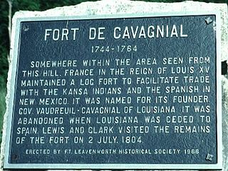
Fort de Cavagnial was a French fort and trading post located on the west cliffs of the Missouri River, somewhere north of Kansas City, Kansas, and Fort Leavenworth, Kansas, from 1744 until about 1764. While the ruins of the site were still visible when Meriwether Lewis and William Clark ventured in the area during their famed 1804 westward expedition, all traces of the fort were eventually lost by the mid-19th century. Today, the exact location of the fort is a mystery.

"Indian Reserve" is a historical term for the largely uncolonized land in North America that was claimed by France, ceded to Great Britain through the Treaty of Paris (1763) at the end of the Seven Years' War—also known as the French and Indian War—and set aside for the First Nations in the Royal Proclamation of 1763. The British government had contemplated establishing an Indian barrier state in the portion of the reserve west of the Appalachian Mountains, and bounded by the Ohio and Mississippi rivers and the Great Lakes. British officials aspired to establish such a state even after the region was assigned to the United States in the Treaty of Paris (1783) ending the American Revolutionary War, but abandoned their efforts in 1814 after losing military control of the region during the War of 1812.

The Harmar campaign was an Autumn 1790 attempt by the United States to subdue Native Americans nations in the Northwest Territory that were seen as hostile. The campaign was led by General Josiah Harmar, and is considered a significant campaign of the Northwest Indian War. The campaign ended with a series of battles from 19-21 October 1790 near the Miami villages of Kekionga. These were all overwhelming victories for the Native Americans, and are sometimes collectively referred to as Harmar's Defeat.

Jesuit missions in North America began early in the 17th century, faltered at the beginning of the 18th, disappeared during the suppression of the Society of Jesus around 1763, and returned around 1830 after the restoration of the Society. The missions were established as part of the colonial drive of France and Spain during the period, the "saving of souls" being an accompaniment of the constitution of Nouvelle-France and early New Spain. The efforts of the Jesuits in North America were paralleled by their China missions on the other side of the world, and in South America. They left written documentation of their efforts, in the form of The Jesuit Relations.

The Pays d'en Haut was a territory of New France covering the regions of North America located west of Montreal. The vast territory included most of the Great Lakes region, expanding west and south over time into the North American continent as the French had explored. The Pays d'en Haut was established in 1610 and dependent upon the colony of Canada until 1763, when the Treaty of Paris ended New France, and both were ceded to the British as the Province of Quebec.
Colonial American military history is the military record of the Thirteen Colonies from their founding to the American Revolution in 1775.
