
Old San Juan is a historic district located at the "northwest triangle" of the islet of San Juan in San Juan. Its area roughly correlates to the Ballajá, Catedral, Marina, Mercado, San Cristóbal, and San Francisco sub-barrios (sub-districts) of barrio San Juan Antiguo in the municipality of San Juan, Puerto Rico. Old San Juan is the oldest settlement within Puerto Rico and the historic colonial district of the city of San Juan. This historic district is a National Historic Landmark District named Zona Histórica de San Juan and is listed on the United States National Register of Historic Places as the Old San Juan Historic District. Several historical buildings and structures, particularly La Fortaleza, the city walls, and El Morro and San Cristóbal castles, have been inscribed in the UNESCO World Heritage Site list since 1983. Historically the mixed-use commercial and residential real estate in the main streets of Calle Cristo and Calle Fortaleza from Calle Tanca to the Governor’s Mansion is the most valuable in the area and it has kept its value and increased steadily through several years despite the past economic turmoils.

Fort Matanzas National Monument is the site where the Spanish built a fort. It was designated a United States National Monument on October 15, 1924. The monument consists of a 1740 Spanish fort called Fort Matanzas, and about 100 acres (0.4 km2) of salt marsh and barrier islands along the Matanzas River on the northern Atlantic coast of Florida. It is operated by the National Park Service in conjunction with the Castillo de San Marcos National Monument in the city of St. Augustine.

Fort Point, known historically as the Castillo de San Joaquín is a masonry seacoast fortification located on the southern side of the Golden Gate at the entrance to San Francisco Bay. It is also the geographic name of the promontory upon which the fort and the southern approach of the Golden Gate Bridge were constructed.
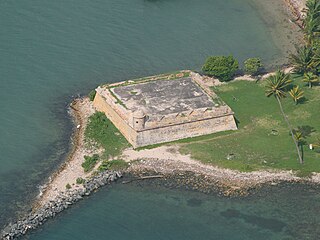
Fortín San Juan de la Cruz, most commonly known as El Cañuelo, was built on Isla de Cabras in the Palo Seco barrio of the municipality of Toa Baja, at the western end of the entrance to San Juan Bay, in Puerto Rico. The square coastal fort has massive sandstone walls that date back to the 1630s. Although the U.S. Navy bombarded the fort in 1898, the fort survived. Today the fort is part of the San Juan National Historic Site, which is listed as a UNESCO World Heritage Site and on the National Register of Historic Places. The fort is not open to visitors, but it can be viewed from its exterior.

Humåtak is a village on the southwestern coast of the United States territory of Guam. The month of March in the Chamorro language is "Umatalaf," or "to catch guatafi," which is believed to be the root word of Umatac. The village's population has decreased since the island's 2010 census, and it is by far the least populated village on the island.

Las Trampas or just Trampas, is an unincorporated hamlet in Taos County, New Mexico. Founded in 1751 to settle the Las Trampas Land Grant, its center retains the original early Spanish colonial defensive layout as well as the 18th-century San José de Gracia Church, one of the finest surviving examples of Spanish colonial church architecture in the United States. The village center was designated a National Historic Landmark District in 1967. The population in 2023 was 43.

The Jemez Historic Site is a state-operated historic site on New Mexico State Road 4 in Jemez Springs, New Mexico. The site preserves the archaeological remains of the 16th-century Native American Gíusewa Pueblo and the 17th-century Spanish colonial mission called San José de los Jémez. The site was listed on the National Register of Historic Places in 1973, and in 2012 it was designated as a National Historic Landmark. It is considered an ancestral site of the Jemez Pueblo people who live nearby.
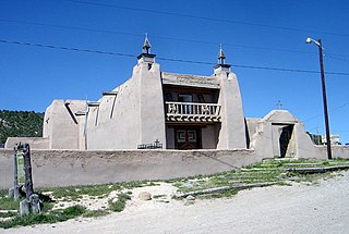
The San Jose de Gracia Church, also known as Church of Santo Tomas Del Rio de Las Trampas, is a historic church on the main plaza of Las Trampas, New Mexico. Built between 1760 and 1776, it is one of the least-altered examples of a Spanish Colonial Pueblo mission church, with adobe walls rising 34 feet (10 m) in height. It was declared a National Historic Landmark in 1970.

San Estévan del Rey Mission Church is a Spanish mission church in the Roman Catholic Diocese of Gallup on the Acoma Pueblo Reservation in western New Mexico. Built between 1629 and 1641, it is one of the finest extant examples of hybrid Spanish Colonial and Puebloan architectural styles. It was named for Saint Stephen I of Hungary. The church was declared a National Historic Landmark in 1970, and is listed on the National Register of Historic Places. It remains a mission church and is part of the parish of San José de la Laguna in Laguna, New Mexico.

Mission Nuestra Señora del Espíritu Santo de Zúñiga, also known as Aranama Mission or Mission La Bahía, was a Roman Catholic mission established by Spain in 1722 in the Viceroyalty of New Spain—to convert native Karankawa Indians to Christianity. Together with its nearby military fortress, Presidio La Bahía, the mission upheld Spanish territorial claims in the New World against encroachment from France. The third and final location near Goliad, Texas is maintained now as part of Goliad State Park and Historic Site

The San Dionisio Church Ruins are a historic ruins on Route 2 in Umatac, Guam. They are the remains of a church that was built in 1862 and destroyed by an earthquake in 1892. It was built out of manposteria, and the surviving elements including buttresses rising to a height of 13 feet (4.0 m). The ruins are the only surviving remnant of the Spanish colonial headquarters complex that stood in this area. The first San Dionisio Church was constructed in 1681, but rebuilt after a fire three years later. That church was destroyed in 1849 by an earthquake, and portions may have been used in construction of the 1862 building. A new church was built in 1939. The ruins were added to the National Register of Historic Places in 1974.

Fort Nuestra Señora de la Soledad is a fortification near Umatac, Guam. Built by the Spanish probably between 1802 and 1819, it was the fourth of four fortifications that protected an anchorage for galleons transiting between Acapulco, Mexico and the Philippines, a route that fell out of use in 1815 with Mexican independence.

Cetti Bay is an oceanic bay and historic site near Umatac, Guam, that is listed on the National Register of Historic Places.

Fort Santa Agueda, on Guam Highway 7 in Hagåtña, Guam, dates from about 1800, during the 1784-1802 administration of Spanish governor Manuel Moro. It was an uncovered fort with a manposteria parapet, rising about 10 feet (3.0 m) above a sloping hillside. It is listed on the U.S. National Register of Historic Places, as the only remaining fortification of the Spanish Era in Hagåtña.

The Spanish Wall is the deteriorating remnant of Spanish Fort Alphonso XIII in Kolonia, the capital of Pohnpei State in the Federated States of Micronesia. When built, the wall was about 0.5 miles (0.80 km) in length and 8 feet (2.4 m) in height with a parapet that ranged in height from 2–3 feet (0.61–0.91 m). The wall was built by Spanish administrators of Pohnpei in 1887 after a local uprising drove the local Spanish authorities onto a ship in the harbor. Most of the wall was taken down by the German administration that took over in the early 20th century, after the Spanish–American War. The remains of the wall, about 700 feet (210 m) and two arches, are now part of a local park.
The Taelayag Spanish Bridge is a historic stone bridge in the United States territory of Guam. It is a stone arch bridge, built sometime between 1866 and 1898, and originally carried the coast road between Agat, Guam and Umatac across Taelayag Stream. It is now located about 1,800 feet (550 m) southwest of Guam Highway 2, the modern coast road. The bridge is a single-span stone arch with a span of 8 feet 10 inches (2.69 m) and a total structure length of 27 feet 9 inches (8.46 m). This bridge, like most of the bridges that survive from the Spanish period in Guam, was probably taken out of service around 1917.
Fort Santo Angel was a Spanish fortress on the island of Guam, now a United States territory. Located on a promontory on the west coast of the island in the northernmost part the Umatac Bay in Umatac, the fort's remains are among the oldest known Spanish-era structures on the island; a fort is documented to have been standing here since 1742, and to still be in use in the early 19th century. The fort provided protection for the anchorage used by Spanish galleons on the trade route between Manila and Acapulco, Mexico. Perched on a monolith, there remains a plaza 40 by 24 feet of flagstone surrounded by a manposteria wall 1 foot (30 cm) high and 18 inches (46 cm) thick. The remains of a guardroom and a second, smaller platform, lie to its west.

The Gongna Beach defenses are a collection of World War II structures built on or near Gongna Beach in Tamuning on the island of Guam, now a United States territory. These defenses were erected by the Imperial Japanese Army during its occupation of the island 1941–44. The three surviving elements were listed on the National Register of Historic Places in 1991. They are located well north of the main Allied landing areas of the 1944 Battle of Guam.
The Francisco Q. Sanchez Elementary School is a historic school building on the north side of Guam Highway 2 in Umatac, Guam. It is a single-story International style structure, with two classroom wings flanking a central administration area. The building was designed by noted Internationalist architect Richard J. Neutra, and built in 1953 adjacent to the San Dionisio Church Ruins. Neutra's design sought to integrate the school with its surrounding environment, and provides a panoramic view of Umatac Bay. The building is one of four buildings built pursuant to a master plan developed by Neutra and Robert J. Alexander. It is Umatac's only school.

The Creamery Covered Bridge is a historic covered bridge in West Brattleboro, Vermont. Now closed to traffic, the Town lattice truss bridge formerly carried Guilford Road across Whetstone Brook, just south of Vermont Route 9. Built in 1879, it is Brattleboro's last surviving 19th-century covered bridge.

