The fortifications of Metz, a city in northeastern France, are extensive, due to the city's strategic position near the border of France and Germany. After the Franco-Prussian War of 1870, the area was annexed by the newly created German Empire in 1871 by the Treaty of Frankfurt and became a Reichsland. The German Army decided to build a fortress line from Mulhouse to Luxembourg to protect their new territories. The centerpiece of this line was the Moselstellung between Metz and Thionville, in Lorraine.

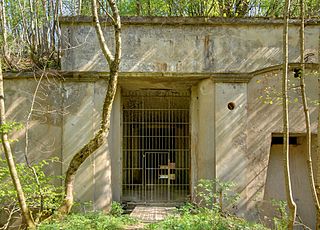
A casemate is a fortified gun emplacement or armored structure from which guns are fired, in a fortification, warship, or armoured fighting vehicle. Originally, the term referred to a vaulted chamber in a fort, which may have been used for storage, accommodation, or artillery which could fire through an opening or embrasure. Although the outward faces of brick or masonry casemates proved vulnerable to advances in artillery performance, the invention of reinforced concrete allowed newer designs to be produced well into the 20th century. With the introduction of ironclad warships, the definition was widened to include a protected space for guns in a ship, either within the hull or in the lower part of the superstructure. Although the main armament of ships quickly began to be mounted in revolving gun turrets, secondary batteries continued to be mounted in casemates; however several disadvantages eventually also led to their replacement by turrets. In tanks that do not have a turret for the main gun, the structure that accommodates the gun is also called a casemate.

Ouvrage Barbonnet is a work of the Maginot Line's Alpine extension, the Alpine Line, also called the Little Maginot Line. The ouvrage consists of one entry block and one infantry block facing Italy. The ouvrage was built somewhat behind the main line of fortifications on the old Fort Suchet, which was already armed with two obsolete Mougin 155mm gun turrets.

Fort de Sucy was built following the Franco-Prussian War to defend Paris. Located to the southeast of Paris in Sucy-en-Brie, the fort was part of an outer ring of eighteen major fortifications built in response to improvements in the range and effectiveness of artillery since the construction of the Thiers fortifications of the 1840s. It was built in accordance with improved principles of fortification developed for the Séré de Rivières system.

Fort du Salbert, also known as Fort Lefebvre, was built between 1874 and 1877. It was named after General François Joseph Lefebvre. It forms part of the Séré de Rivières system fortifications in the fortified region of Belfort in northeastern France. It is located at the summit of Salbert hill to the northwest of Belfort. During the early years of the Cold War it briefly served as an air defense coordination center.
Fort de Roppe, also known as Fort Ney, was built between 1875 and 1877. It is part of the second ring of fortifications around the city of Belfort in northeastern France. This set of forts was built as part of the Séré de Rivières system and incorporated improvements to deal with the improvement in efficacy of artillery in the late 19th century.

Fort des Basses Perches, also known as Fort Valmy, was built between 1874 and 1877 in Danjoutin and Belfort in northeastern France. It is part of the first ring of fortifications around the city of Belfort. The Forts des Perches were unique among the first group in their re-use of older sites. They were rebuilt as part of the Séré de Rivières system and incorporated improvements to deal with the improvement in efficacy of artillery in the late 19th century. The fort's official name was derived from François-Christophe Kellermann, Duke of Valmy and Marshal of France.

Fort de Vézelois, also known as Fort Ordener, was built between 1883 and 1886 near Vézelois, to the southeast of Belfort in northeastern France. It is part of the first ring of fortifications around the city of Belfort. It is part of the second ring of fortifications around the city of Belfort in northeastern France. This set of forts was built as part of the Séré de Rivières system and incorporated improvements to deal with the improvement in efficacy of artillery in the late 19th century. The fort was formally named after French General Michel Ordener.
Fort de Giromagny, also known as Fort Dorsner, was built near Belfort in northeastern France between 1875 and 1879. The fort forms the southern end of the defensive curtain of the Haute Moselle Region, abutting the Fortified region of Belfort, which lies to its south. The Haute Moselle defenses form a link between the fortified encampments of Épinal and Belfort. The fort overlooks the main roads to the northeast of Belfort, which form a crossroads at Giromagny.

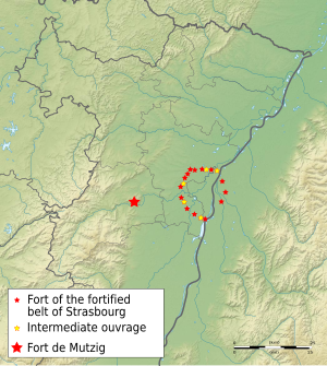
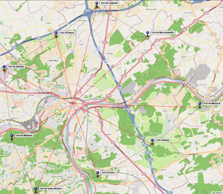
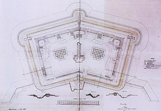
The Fort de Guentrange dominates Thionville in the Moselle department of France. It was built by Germany next to the town of the same name in the late 19th century after the annexation of the Moselle following the Franco-Prussian War. The Fort de Guentrange was part of the Moselstellung, a group of eleven fortresses surrounding Thionville and Metz to guard against the possibility of a French attack aimed at regaining Alsace and Lorraine, with construction taking place between 1899 and 1906. The fortification system incorporated new principles of defensive construction to deal with advances in artillery. Later forts, such as Guentrange, embodied innovative design concepts such as dispersal and concealment. The later forts were designed to support offensive operations, as an anchor for a pivoting move by German forces into France.

The Fort d'Illange is a fortification located to the south of Thionville in the Moselle department of France. It was built by Germany next to the town of Illange in the early 20th century after the annexation of the Moselle following the Franco-Prussian War. The Fort d'Illange was part of the Moselstellung, a group of eleven fortresses surrounding Thionville and Metz to guard against the possibility of a French attack aimed at regaining Alsace and Lorraine, with construction taking place between 1905 and 1911. The fortification system incorporated new principles of defensive construction to deal with advances in artillery. Later forts, such as Illange, embodied innovative design concepts such as dispersal and concealment. These later forts were designed to support offensive operations, as an anchor for a pivoting move by German forces into France.
Fort Jeanne d'Arc, also called Fortified Group Jeanne d'Arc, is a fortification located to the west of Metz in the Moselle department of France. It was built by Germany to the west of the town of Rozérieulles in the early 20th century as part of the third and final group of Metz fortifications. The fortification program was started after the German victory of the Franco-Prussian War, which resulted in the annexation of the provinces of Alsace and Lorraine from Germany to France. The Fort Jeanne d'Arc was part of the Moselstellung, a group of eleven fortresses surrounding Thionville and Metz to guard against the possibility of a French attack aimed at regaining Alsace and Lorraine, with construction taking place between 1899 and 1908. The fortification system incorporated new principles of defensive construction to deal with advances in artillery. Later forts, such as Jeanne d'Arc, embodied innovative design concepts such as dispersal and concealment. These later forts were designed to support offensive operations, as an anchor for a pivoting move by German forces into France.
The Fort d'Uxegney, or Fort Roussel, is part of the fortifications of Épinal. It was built near the village of Uxegney between 1882 and 1884, and was modernized in 1910. It is an example of a Séré de Rivières system fortification. It retains its armament and is maintained as a museum.
The Fort de Plappeville, or Feste Alvensleben, is a military fortification located to the northwest of Metz in the commune of Plappeville. As part of the first ring of the fortifications of Metz, it is an early example of a Séré de Rivières system fort. While it did not see action during World War I, it was the scene of heavy fighting between American forces and German defenders at the end of the Battle of Metz, in 1944. After Second World War it became a training center for the French Air Force. Fort 'Alvensleben' has been abandoned since 1995.
The Fort de Leveau, also known as Fort Schouller, is located in the commune of Feignies, France. It is part of the fortifications of Maubeuge, located to the northwest of the city, overlooking the railroad to Mons. The Séré de Rivières system fort was built 1882–1884, one of six forts built at the time. It is maintained as a museum by the town of Feignies.
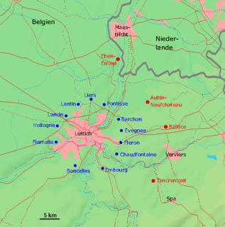
The fortified position of Liège was established after the First World War by Belgium to block the traditional invasion corridor through Belgium between Germany and France. In the First World War the Belgian Army held up the Germans for a week at Liège, delaying the German invasion of France, caused Belgium to consider a similar defensive strategy. Belgium rebuilt the Liège fortifications and extended them onto the Pays de Herve closer to Germany, using the most advanced fortification technology available.
The fortified position of Namur was established by Belgium after the First World War to fortify the traditional invasion corridor between Germany and France through Belgium. The position incorporated the fortress ring of Namur, originally designed by the Belgian General Henri Alexis Brialmont to deter an invasion of Belgium by France. The old fortifications consisted of nine forts built between 1888 and 1892 on either side of the Meuse, around Namur.
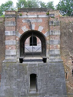
The Fort de St-Héribert or the Fort de Wépion is one of nine forts built as part of the Fortifications of Namur in the late 19th century in Belgium. It was built between 1888 and 1892 according to the plans of General Henri Alexis Brialmont. Contrasting with the French forts built in the same era by Raymond Adolphe Séré de Rivières, the fort was built exclusively of unreinforced concrete, a new material, rather than masonry. In 1914 the fort was heavily bombarded by German artillery in the Battle of Namur. Maizeret was upgraded in the 1930s to become part of the fortified position of Namur in an attempt to forestall or slow an attack from Germany. It saw action in 1940 during the Battle of Belgium, and was captured by German forces. The fort now belongs to the private Fondation Emile Legros. The foundation has already unearthed the main entrance and other areas.

The Fort de Suarlée is one of nine forts built as part of the Fortifications of Namur in the late 19th century in Belgium. It was built between 1888 and 1892 according to the plans of General Henri Alexis Brialmont. Contrasting with the French forts built in the same era by Raymond Adolphe Séré de Rivières, the fort was built exclusively of unreinforced concrete, a new material, rather than masonry. In 1914 the fort was heavily bombarded by German artillery in the Battle of Namur. Suarlée was upgraded in the 1930s to become part of the fortified position of Namur in an attempt to forestall or slow an attack from Germany. It saw action in 1940 during the Battle of Belgium, and was captured by German forces. The fort is now abandoned on private property.
A polygonal fort is a type of fortification originating in France in the late 18th century and fully developed in Germany in the first half of the 19th century. Unlike earlier forts, polygonal forts had no bastions, which had proved to be vulnerable. As part of ring fortresses, polygonal forts were generally arranged in a ring around the place they were intended to protect, so that each fort could support its neighbours. The concept of the polygonal fort proved to be adaptable to improvements in the artillery which might be used against them, and they continued to be built and rebuilt well into the 20th century.