Fortified Granaries of Aures

Last updated
Fortress of Ath Mansour
Fort of Ath Mansour.jpg
Aures 1929
Algeria location map.svg
Archaeological site icon (red).svg
Shown within Algeria
Location Batna Province, Algeria
Coordinates 35°05′25.0″N6°01′51.6″E / 35.090278°N 6.031000°E / 35.090278; 6.031000
Type fortified granaries
History
MaterialStone
Abandoned20th century
Cultures Chaoui people
Site notes
ConditionIn ruins
Public accessAvailable

The Fortified granaries of Aures known as "taq'liath" in Shawiya, are a multi-storied defensible structures used for storing crops as well as a refuge during times of conflict. They were described in ancient times by Roman and Arab sources alike. 11th century Andalusian historian, Al-Bakri, specified that Aures had a large number of fortresses surrounded by water streams, These were dwellings of the Miknasa and Houara Berber tribes. [1] in 1878, the fortresses were rediscovered by French anthropologist Émile Masqueray who produced a picturesque description of these "Eagle nests". [2] [3]

Contents

Etymology

The term "Guelaa/Kalaa: plural:"taq'liath" is derived from the Arabic word for "citadel" or "fort", Similar structures across North Africa have different names: in the Moroccan Sous region, they are called "Agadir", a loan-word from phoenician that mean "wall", while in southern Tunisia, they are referred to as "ghorfa" meaning "room". These variations in terminology highlight the cultural specificity of these structures. [4] [5]

Development

A close examination of Auresian dwellings reveals a continuum of architectural evolution from simple caves to the multi-storied stone granaries, The development of the fortified granaries of Aures is thus rooted in the agricultural and security needs of the Auresian people. In ancient times, the open crop fields were vulnerable to raids by camel marauders, prompting the cultivation of land closer to high altitude fortified granaries and the construction of terrace gardens for irrigation.

The Auresians often attribute their agricultural techniques to the Romans, whose ruins are scattered across the region. However, the influence likely extends to earlier civilizations that refined existing agricultural methods in North Africa, as historians have often identified fortified granaries, such as those in Ath Mansur and Jellal, with the ancient Numidian strongholds, with villages perched on rocky hills and accessible only by narrow paths. [6] These structures, with single gateways, demonstrate a modern example of Jugurtha's treasure houses described by Sallust in antiquity. [7] [8]

Historian Jean Despois notes that these granaries are emblematic of the Auresian political, social, and economic structures. In Aures, power resided with the heads of families within clans and fractions, or with their elected representatives, reflecting a highly organized and egalitarian society. These "Berber republics" resisted central control and Arabization, with the granaries symbolizing the cohesion and independence of these small, autonomous communities. [9]

While the use of granaries as dwellings has diminished under French colonial rule, they remain a significant part of the Aures Mountains' cultural heritage. One notable example is the Ait Daoud clan. Their granary, which stands eight stories high, continued to be a place of veneration for their ancestral saints. Each month of May, members go there to perform a pledge of fertility, sacrifice animals, and eat a communion meal. [10]

Design

The fortified granaries of Aures are predominantly stone-built, with roofs reinforced by palm tree trunks. These granaries, often square in shape, sometimes include openings for ventilation and light, adorned with symbolic decorations that reflect the community's deep connection to agriculture and nature. High-elevation springs were used to fill reservoirs at night. Water was then channeled to terrace gardens through a network of miniature canals, ensuring efficient irrigation and crop maintenance. [11] [6]

The size of the granary depends on the prestige of the clan, The leading family often selects a caretaker, typically a poorer member who doesn't own land. This caretaker stays at the granary, maintaining order. They clear the snow, report water infiltrations, and assist with unloading grain, of which they take a portion as payment. The main gate stays closed, and the guard only opens it after being alerted by their dog's barking and verifying the visitor. [12]

Defensive role

Centuries after Sallust's description of the fortified treasure houses, the Byzantine historian Procopius shed light on these structures again, noting their use by Iaudas, the ruler of the Aures kingdom, against the invading Romans. Procopius describes how water canals were employed to divert water and repel the Roman forces. [13]

The tactics used by Iaudas were echoed in the 17th century in the same region. This time, the Auresians diverted water streams to flood the fields surrounding their granaries, successfully massacring the invading Arab Bedouins in the process. [14]

Preservation efforts

The fortified granaries of Aures, despite their notable importance to the heritage of the region and Algeria as a whole, remain largely neglected and vulnerable. In 2023, advocacy efforts from local activists have drawn the attention of an Italian mission from the University of Padua which later toured the region to inspect these structures. [15] [ better source needed ]

Related Research Articles

<span class="mw-page-title-main">Numidia</span> Berber kingdom in North Africa (202 BC - 46 AD)

Numidia was the ancient kingdom of the Numidians in northwest Africa, initially comprising the territory that now makes up Algeria, but later expanding across what is today known as Tunisia and Libya. The polity was originally divided between the Massylii in the east and the Masaesyli in the west. During the Second Punic War, Masinissa, king of the Massylii, defeated Syphax of the Masaesyli to unify Numidia into the first Berber state in present-day Algeria. The kingdom began as a sovereign state and later alternated between being a Roman province and a Roman client state.

<span class="mw-page-title-main">Shawiya language</span> Zenati Berber language spoken in Algeria

Shawiya, or Shawiya Berber, also spelt Chaouïa, is a Zenati Berber language spoken in Algeria by the Shawiya people. The language's primary speech area is the Awras Mountains in Eastern Algeria and the surrounding areas, including parts of Western Tunisia, including Batna, Khenchela, Sétif, Oum El Bouaghi, Souk Ahras, Tébessa and the northern part of Biskra. It is closely related to the Shenwa language of Central Algeria.

<span class="mw-page-title-main">Tanit</span> Goddess of Carthage

Tanit or Tinnit was a chief deity of Ancient Carthage; she derives from a local Berber deity and the consort of Baal Hammon. As Ammon is a local Libyan deity, so is Tannit, which she represents the matriarchal aspect of Numidian society, whom the Egyptians identify as Neith and the Greeks identify as Athena. She was the goddess of Wisdom, civilization and the crafts; she is the defender of towns and homes where she is worshipped. Ancient North Africans used to put her sign on tombstones and homes to ask for protection, her main temples in Thinissut, Cirta, Lambaesis and Theveste.

<span class="mw-page-title-main">Kasbah</span> Type of fortress in Arab or Islamic regions

A kasbah, also spelled qasba, qasaba, or casbah, is a fortress, most commonly the citadel or fortified quarter of a city. It is also equivalent to the term alcazaba in Spanish, which is derived from the same Arabic word. By extension, the term can also refer to a medina quarter, particularly in Algeria. In various languages, the Arabic word, or local words borrowed from the Arabic word, can also refer to a settlement, a fort, a watchtower, or a blockhouse.

<span class="mw-page-title-main">Chaoui people</span> Berber ethnic group in northeast Algeria

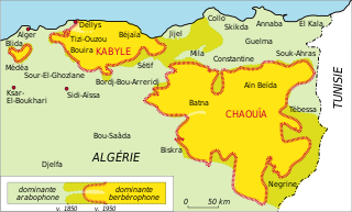
The Chaoui people or Shawyia are a Berber ethnic group native to the Aurès region in northeastern Algeria which spans Batna and Khenchla, Oum El Bouaghi provinces located in and surrounded by the Aurès Mountains.

<span class="mw-page-title-main">Gabriel Camps</span>

Gabriel Camps was a French archaeologist and social anthropologist, the founder of the Encyclopédie berbère and is considered a prestigious scholar on the history of the Berber people.

Antalas was a Berber tribal leader who played a major role in the wars of the Byzantine Empire against the Berber tribes in Africa. Antalas and his tribe, the Frexes initially served the Byzantines as allies, but after 544 switched sides. With the final Byzantine victory in his and his tribe once again became Byzantine subjects. The main sources on his life are the epic poem Iohannis of Flavius Cresconius Corippus and the Histories of the Wars of Procopius of Caesarea.

<span class="mw-page-title-main">Bilta</span> Place in Tunisia

Bilta also known as Balta or Balţah, is an antique town in northern Tunisia, close to Mateur in today's Bizerte governorate. Its name comes from the Numidian language (Lybico-Berber) root BLT, meaning, filled with water.

<span class="mw-page-title-main">Mastanabal</span> King of Numidia

Mastanabal was one of three legitimate sons of Masinissa, the King of Numidia, a Berber kingdom in, present day Algeria, North Africa. The three brothers were appointed by Scipio Aemilianus Africanus to rule Numidia after Masinissa's death.

<span class="mw-page-title-main">Agadir (granary)</span>

An agadir is a fortified communal granary found in the Maghreb.

The Battle of Tabarka was a military engagement fought between the forces of the Umayyad Caliphate and Dihya, a Berber queen. The battle took place near the city of Tabarka, Tunisia, in either 701, 702 or 703 AD. The battle resulted in a major victory for the Umayyads and the end of organized Berber resistance to the caliphate.

The Crusade of Tedelis was a major conflict within the overarching struggle between the Crown of Aragon and the Kingdom of Tlemcen in the late 14th century.

<span class="mw-page-title-main">Agadez Cross</span> Symbol

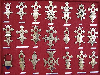
The Agadez Cross is the most popular category of Saharan Berber jewelry made especially by the Tuareg people of Niger. Only a few of these pieces of jewelry exactly resemble a cross. For most of them, it is a pendant with a varied silhouette, related either to a cross (tanaghilt), or to a form of plate or shield (talhakim). The former is made of stone or copper. The blacksmiths generally use silver and the so-called "lost wax" casting process without ever hammering the metal.

Ikjan is a former town near the present-day town of Beni Aziz in Algeria. Between 902 and 909 it served as the base and capital of the Kutama Berbers led by the dā'ī (missionary) Abu Abdallah al-Shi'i, who had founded an Isma'ili Shi'a state in the region on behalf of the Fatimid cause. This new movement rose in opposition to the Aghlabid dynasty, which ruled the region of Ifriqiya formally on behalf of the Abbasid Caliphs. The site of Ikjan was considered impregnable. In 909 Abu Abdallah and the Kutama armies finally overthrew the Aghlabids and set themselves up in Raqqada, laying the foundations for the Fatimid Caliphate, which was formally established with the enthronement of the first caliph, Abd Allah al-Mahdi, later that year.

<span class="mw-page-title-main">Jewellery of the Berber cultures</span> Traditional jewellery of Berber peoples in North Africa

Jewelleryof the Berber cultures is a historical style of traditional jewellery that was worn by women mainly in rural areas of the Maghreb region in North Africa and inhabited by indigenous Berber people. Following long social and cultural traditions, Berber or other silversmiths in Morocco, Algeria and neighbouring countries created intricate jewellery with distinct regional variations. In many towns and cities, there were Jewish silversmiths, who produced both jewellery in specific Berber styles as well as in other styles, adapting to changing techniques and artistic innovations.

<span class="mw-page-title-main">Awlad Muhammad</span> African tribe

Awlad Muhammad was a tribe that ruled over the Fezzan region from 1550 to 1812. At their height, their domain extended from Sokna in the north to Murzuq in the south.

Banu Khattab was a wealthy Ibadi dynasty of Hawwara origin that thrived off of the Trans-Saharan slave trade. It ruled over Zawila and the surrounding oases in the Fezzan region from 918/919 until 1172–1177 when it was sacked and conquered by the Armenian-Mamluk Qaraqush. The instability created by Qaraqush was exploited by the Kanem, who under the reign of Dunama Dabbalemi had seized control of the Fezzan, establishing a new capital at Traghan, a few miles west of Zawila.

The Ourferdjouma or Urfedjouma, Warfajuma were a large Nefzaoua Sufrite Berber tribe. After capturing Kairouan in 757-758 from the Fihrids, the Ourferdjouma plundered the city and massacred the population. These atrocities and the desecration of the Grand Mosque of Kairouan provoked the Ibadi Berbers who after capturing Tripoli, occupied Kairouan in 758 putting an end to their terror.

The Aurès Mountains in northeastern Algeria, part of the Saharan Atlas in North Africa, is widely inhabited by Amazighs called Chaouis, and have been an important part of kingdoms such as the Massylii, Numidia, Gaetuli and the Amazigh.

Akhemuk ag Ihemma was the Amenokal, or ruler, of the Kel Ahaggar, a Tuareg confederation in present-day Algeria. His reign fell within a period of French colonial rule over the region.

References

  1. "ص831 - كتاب المسالك والممالك للبكري - الطريق من مدينة فاس إلى مدينة القيروان - المكتبة الشاملة". shamela.ws. Retrieved 2024-07-13.
  2. E. B; Peyron, M.; Vignet-Zunz, J. (1999-09-01). "Greniers". Encyclopédie berbère (in French) (21): 3213–3222. doi:10.4000/encyclopedieberbere.1780. ISSN   1015-7344.
  3. Ould-Braham, Ouahmi (1999). "Mission scientifique de Masqueray dans l'Aurès et ses dépendances (1875-1878)". Études et Documents Berbères (in French). 17 (1): 19–129. doi:10.3917/edb.017.0019. ISSN   0295-5245.
  4. Christian Sorand (2021). "Preserving the Amazigh Fortified Granaries". Academia Letters: 1. doi:10.20935/AL3821.
  5. Golvin, L. (1989-01-01). "Architecture berbère". Encyclopédie berbère (in French) (6): 865–877. doi:10.4000/encyclopedieberbere.2582. ISSN   1015-7344.
  6. 1 2 M. W. Hilton-Simpson (1922). "The Influence of Geography on the People of the Aures Massif, Algeria". The Geographical Journal. 59 (1): 25–26. Bibcode:1922GeogJ..59...19H. doi:10.2307/1781855. JSTOR   1781855.
  7. The Geographical Journal 1922-01: Vol 59 Iss 1. Internet Archive. Blackwell Publishing Ltd. January 1922.{{cite book}}: CS1 maint: others (link)
  8. "LacusCurtius • Sallust — The War With Jugurtha (3)". penelope.uchicago.edu. Retrieved 2024-07-13.
  9. E. B; Leveau, Ph; Morizot, P.; Morizot, J.; Chamla, M.-C.; Demoulin, F.; Adjali, S.; Chaker, S. (1990-07-01). "Aurès". Encyclopédie berbère (in French) (8): 1097–1169. doi:10.4000/encyclopedieberbere.258. ISSN   1015-7344.
  10. Urbain-Faublée, Marcelle (1951). "Magasins collectifs de l'Oued el Abiod (Aurès)". Journal des Africanistes. 21 (2): 139–150. doi:10.3406/jafr.1951.1833.
  11. "La Préservation des greniers fortifiés Amazighs". Inumiden (in French). 2021-12-12. Retrieved 2024-07-13.
  12. Urbain-Faublée, Marcelle (1951). "Magasins collectifs de l'Oued el Abiod (Aurès)". Journal des Africanistes. 21 (2): 139–150. doi:10.3406/jafr.1951.1833.
  13. Procopius, HISTORY OF THE WARS, IV. xix. 6-15, translation by H.B. Dewing, Pages 379-381
  14. Kitab Tarikh Al-Udwani, Pages 335-336
  15. "Facebook". www.facebook.com. Retrieved 2024-07-13.