
The Fortress Study Group is a charity registered in the UK with an international membership. [1] Its purpose is advancing the study of post-medieval artillery fortifications throughout the World.
The Fortress Study Group is a charity registered in the UK with an international membership. [1] Its purpose is advancing the study of post-medieval artillery fortifications throughout the World.

The Fortress Study Group was formed in June 1975 at Pembroke College, Oxford amongst the founders were Jock Hamilton-Baillie, who became chairman in 1976, the late Quentin Hughes was the founding editor of the annual journal, and his Royal Highness the Duke of Gloucester remains as patron. Other notable members, past and present include Christopher Duffy, Simon Pepper, Anthony Kemp, Victor Smith, David Barnes, Major Davies & Mrs Davies, Sheila Sutcliffe, Arthur Corney, Henry Wills and the late Andrew Saunders, Ian V. Hogg and General Whitworth. There are currently around 600 members worldwide. [2]
The Group publishes an annual peer reviewed journal entitled FORT which contains articles on fortifications throughout the world. Three times as year a newsletter, CASEMATES, is published which also covers visits to fortifications, new and reviews. Annual Conferences and lecture days are held in the UK in order to disseminate new research on the subject. Tours of fortifications outside the UK are also organised, often with access to sites not open to the public, in co-operation with other similar groups and local councils. There is a specialist library on the subject of fortification which is held at Fort Nelson as part of the Armouries Collection.
The group also offers small grants for the publication of works on fortification, such as Ramparts of Empire [3] and to Castle, Town defences and Artillery Fortifications in Britain and Ireland: a Bibliography 1945-2006 [4]
The preservation of fortifications through providing specialist advice to planners, developers, local authorities and owners. Small grants have also been made, called FSG Preservation Grants. For example, to: High Knoll Fort, St Helena; The Needles Battery, Isle of Wight for gun carriage restoration; the Royal Engineers Library and Museum, Chatham for a new display model of Fort Cliffe; and Fort Tourgis, Alderney for new signage for a battery. Starting in 2014 FSG makes an award to distinguish outstanding renovation of fortifications; the FSG Award is a plaque and was first awarded to Landguard Fort in Felixstowe. [5]
The Fortress Study Group was involved in the Defence of Britain Project [6] (April 1995 - March 2002) which aimed to record all surviving 20th century defences in Britain. The group surveyed 270 sites on the Holderness coast in the UK in 1992 on behalf of the Royal Commission on the Historic Monuments of England. This formed the basis of the Defence of Britain Project under the Council for British Archaeology.
In December 2015 a new joint project was started: The Defence of Gibraltar Project. It is a collaborative effort between the Friends of Gibraltar and the Fortress Study Group. The Government of Gibraltar is fully supporting this endeavour. The purpose of this Project is to create a definitive database of the military landscape in Gibraltar (circa 1704 to 1960). The information will be collected from field visits and examination of historic documents. At this stage it is proposed to run the project for two years, subject to an annual review on progress. The information collected on the database will be made available to the Government of Gibraltar, and in particular the Gibraltar Heritage Trust, with a view to the future preservation of sites of interest. The newly formed, Fortress of Gibraltar Group are also coordinating their research with this Project, concentrating their efforts on the World War 2 landscape. See [7]
Individual members have also been involved with restoration projects such as Fort Amherst, Harwich Redoubt, The Needles Batteries, Newhaven Fort and Chapel Bay Fort.

Fort York is an early 19th-century military fortification in the Fort York neighbourhood of Toronto, Ontario, Canada. The fort was used to house members of the British and Canadian militaries, and to defend the entrance of the Toronto Harbour. The fort features stone-lined earthwork walls and eight historical buildings within them, including two blockhouses. The fort forms a part of Fort York National Historic Site, a 16.6 ha (41-acre) site that includes the fort, Garrison Common, military cemeteries, and a visitor centre.

The Western Heights of Dover are one of the most impressive fortifications in Britain. They comprise a series of forts, strong points and ditches, designed to protect the country from invasion. They were created in the 18th and 19th centuries to augment the existing defences and protect the key port of Dover from both seaward and landward attack; by the start of the 20th century Dover Western Heights was collectively reputed to be the 'strongest and most elaborate' fortification in the country. The Army finally withdrew from the Heights in 1956–61; they are now a local nature reserve.
Beacon Hill Battery is a late-19th and 20th century coastal fortification that was built to defend the port of Harwich, Essex. It is a scheduled ancient monument.

The Royal Commission on the Defence of the United Kingdom was a committee formed in 1859 to enquire into the ability of the United Kingdom to defend itself against an attempted invasion by a foreign power, and to advise the British Government on the remedial action required. The appointment of the Commission had been prompted by public concern about the growing military and naval power of the French Empire and was instigated by the Prime Minister, Henry Temple, 3rd Viscount Palmerston, who came to be closely associated with the project. In the following year, the Commission's report recommended a huge programme of fortification to defend the country's arsenals and naval bases. Many of the recommendations were acted upon; however, the great expense, the length of time taken to complete the various works and their perceived usefulness were all subjects of critical political, press and public debate.

Fort Fareham is one of the Palmerston Forts, in Fareham, England. After the Gosport Advanced Line of Fort Brockhurst, Fort Elson, Fort Rowner, Fort Grange and Fort Gomer had been approved by the Royal Commission on the Defence of the United Kingdom a decision was made to build an outer line of three more forts two miles in advance of the Gosport Advanced Line. Of these three projected forts only Fort Fareham was built due to the need to cut costs. It acted as a hinge between the forts on Portsdown Hill and those of the Gosport Advanced Line, filling the gap at Fareham. It has been a Grade II Listed Building since 1976.

Pendennis Castle is an artillery fort constructed by Henry VIII near Falmouth, Cornwall, England between 1540 and 1542. It formed part of the King's Device programme to protect against invasion from France and the Holy Roman Empire, and defended the Carrick Roads waterway at the mouth of the River Fal. The original, circular keep and gun platform was expanded at the end of the century to cope with the increasing Spanish threat, with a ring of extensive stone ramparts and bastions built around the older castle. Pendennis saw service during the English Civil War, when it was held by the Royalists, and was only taken by Parliament after a long siege in 1646. It survived the interregnum and Charles II renovated the fortress after his restoration to the throne in 1660.

Coastal fortifications were constructed in New Zealand in two main waves: around 1885 as a response to fears of an attack by Russia, and in World War II due to fears of invasion by the Japanese.

Major General Sir John Thomas Jones, 1st Baronet was a British officer in the Royal Engineers who played a leading engineering role in a number of European campaigns of the early nineteenth century. Jones was revered by the Duke of Wellington and asked to advise on fortifications including the modernisation of the defences in Gibraltar. He was also notable as an English amateur cricketer who made six first-class appearances.

A Carnot wall is a type of loop-holed wall built in the ditch of a fort or redoubt. It takes its name from the French mathematician, politician, and military engineer, Lazare Carnot. Such walls were introduced into the design of fortifications from the early nineteenth century. As conceived by Carnot they formed part of an innovative but controversial system of fortification intended to defend against artillery and infantry attack. Carnot walls were employed, together with other elements of Carnot's system, in continental Europe in the years after the final defeat of Napoleon in 1815, especially by the Prussians, other Germans and Austrians. Their adoption was initially resisted by the French themselves and by the British.

Breakneck Battery is an artillery battery in the British Overseas Territory of Gibraltar. It is located on Ministry of Defence property at the Upper Rock Nature Reserve, north of Lord Airey's Battery. It is one of a dozen batteries in Gibraltar that had 9.2-inch (233.7 mm) guns installed around the turn of the twentieth century. The emplacement features a 9.2-inch Mark X breech-loading gun on a Mark V mounting. The battery was refurbished by 10 Signal Regiment in 2012 and 2016 whilst being on Ceremonial duties whilst the Gibraltar Regiment where on exercise and is one of three surviving 9.2-inch gun emplacements at the Upper Ridge of the Rock of Gibraltar. By the late twentieth century, the 9.2-inch guns in Gibraltar, Bermuda, Portugal, South Africa, and Australia were the remaining examples of an emplacement that at one point had been mounted at strategic locations across the British Empire.
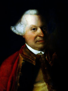
General Sir William Green, 1st Baronet, of Marass, Kent was an officer in the British Army.

The Gibraltar peninsula, located at the far southern end of Iberia, has great strategic importance as a result of its position by the Strait of Gibraltar where the Mediterranean Sea meets the Atlantic Ocean. It has repeatedly been contested between European and North African powers and has endured fourteen sieges since it was first settled in the 11th century. The peninsula's occupants – Moors, Spanish, and British – have built successive layers of fortifications and defences including walls, bastions, casemates, gun batteries, magazines, tunnels and galleries. At their peak in 1865, the fortifications housed around 681 guns mounted in 110 batteries and positions, guarding all land and sea approaches to Gibraltar. The fortifications continued to be in military use until as late as the 1970s and by the time tunnelling ceased in the late 1960s, over 34 miles (55 km) of galleries had been dug in an area of only 2.6 square miles (6.7 km2).

The Lines of Contravallation of Gibraltar, known in English as the "Spanish Lines", were a set of fortifications built by the Spanish across the northern part of the isthmus linking Spain with Gibraltar. They later gave their name to the Spanish town of La Línea de la Concepción. The Lines were constructed after 1730 to establish a defensive barrier across the peninsula, with the aim of preventing any British incursions, and to serve as a base for fresh Spanish attempts to retake Gibraltar. They played an important role in the Great Siege of Gibraltar between 1779 and 1783 when they supported the unsuccessful French and Spanish assault on the British-held fortress. The siege was ended after the lines of contravallation were attacked by British and Dutch forces under the command of the Governor of Gibraltar, General Augustus Eliot. The attack caused the Spanish forces to retreat and abandon the fortifications and the combined British led forces virtually destroyed all the Spanish gun batteries and the enemy cannon and munitions either captured or destroyed. This attack is still commemorated to this day and is known as 'Sortie Day'.

Camden Fort Meagher is a coastal defence fortification close to Crosshaven, County Cork, Ireland. Together with similar structures at Fort Mitchell, Fort Davis (Whitegate), and Templebreedy Battery, the fort was built to defend the mouth of Cork Harbour. Though originally constructed in the 16th century, the current structures of the fort date to the 1860s. Originally named Fort Camden and operated by the British Armed Forces, the fort was handed-over to the Irish Defence Forces in 1938. Renamed Fort Meagher in honour of Thomas Francis Meagher, it remained an Irish military installation until 1989 when the Irish Army handed the fort over to Cork County Council. It remained largely overgrown until 2010 when a group of local volunteers began restoration and development of the fort for heritage and tourism purposes. The fort was renamed Camden Fort Meagher and is now open seasonally to visitors, with exhibits on the fort's Brennan torpedo installation.

The Twydall Profile was a style of fortification used in British and Imperial polygonal forts at the end of the 19th century. The sloping earthworks employed in the Twydall Profile were intended to be quick and inexpensive to construct and to be effective in the face of the more powerful artillery and high explosive ammunition being introduced at that time. The name comes from the village of Twydall in Kent, where the first forts of this type were built.

The fortifications of Malta consist of a number of walled cities, citadels, forts, towers, batteries, redoubts, entrenchments and pillboxes. The fortifications were built over thousands of years, from around 1450 BC to the mid-20th century, and they are a result of the Maltese islands' strategic position and natural harbours, which have made them very desirable for various powers.

The fortifications of Plymouth in Devon are extensive due to its natural harbour, its commanding position on the Western Approaches and its role as the United Kingdom's largest naval base. The first medieval defences were built to defend Sutton Harbour on the eastern side of Plymouth Sound at the mouth of the River Plym, but by the 18th century, naval activity had begun to shift westward to Devonport at the mouth of the River Tamar. During the Victorian era, advances in military technology led to a huge programme of fortification encompassing the whole of Plymouth Sound together with the overland approaches. Many of these works remained in military use well into the 20th century.
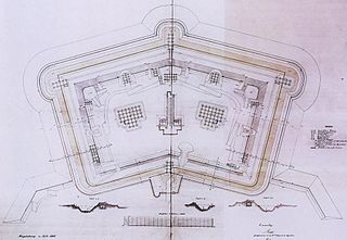
A polygonal fort is a type of fortification originating in France in the late 18th century and fully developed in Germany in the first half of the 19th century. Unlike earlier forts, polygonal forts had no bastions, which had proved to be vulnerable. As part of ring fortresses, polygonal forts were generally arranged in a ring around the place they were intended to protect, so that each fort could support its neighbours. The concept of the polygonal fort proved to be adaptable to improvements in the artillery which might be used against them, and they continued to be built and rebuilt well into the 20th century.

Imperial fortress was the designation given in the British Empire to four colonies that were located in strategic positions from each of which Royal Navy squadrons could control the surrounding regions and, between them, much of the planet.