Luzerne County is a county in the Commonwealth of Pennsylvania. According to the United States Census Bureau, the county has a total area of 906 square miles (2,350 km2), of which 890 square miles (2,300 km2) is land and 16 square miles (41 km2) is water. It is Northeastern Pennsylvania's second-largest county by total area. As of the 2020 census, the population was 325,594, making it the most populous county in the northeastern part of the state. The county seat and largest city is Wilkes-Barre. Other populous communities include Hazleton, Kingston, Nanticoke, and Pittston. Luzerne County is included in the Scranton–Wilkes-Barre–Hazleton Metropolitan Statistical Area, which has a total population of 555,426 as of 2017.

Forty Fort is a borough in Luzerne County, Pennsylvania, United States. The population was 4,233 at the 2020 census. Its neighbors are Wyoming, Plains Township, Kingston, and Swoyersville. The Wilkes-Barre Wyoming Valley Airport and the Wyoming Seminary Lower School are both located in the borough.

Kingston is a borough in Luzerne County, Pennsylvania, United States. It is located on the western bank of the Susquehanna River opposite Wilkes-Barre. Kingston was first settled in the early 1770s, and incorporated as a borough in 1857. As of the 2020 census, the population was 13,349, making it the most populous borough in Luzerne County.

Plymouth Township is located in Luzerne County, Pennsylvania, United States. The population was 1,712 at the 2020 census.

Wyoming is a borough in the Greater Pittston area of Luzerne County, Pennsylvania, United States. It is located 5 miles (8 km) north of Wilkes-Barre, along the Susquehanna River. The population was 3,097 as of the 2020 census.
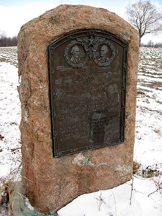
The 1779 Sullivan Expedition was a United States military campaign during the American Revolutionary War, lasting from June to October 1779, against the four British allied nations of the Iroquois. The campaign was ordered by George Washington in response to the 1778 Iroquois and British attacks on Wyoming, German Flatts, and Cherry Valley. The campaign had the aim of "taking the war home to the enemy to break their morale". The Continental Army carried out a scorched-earth campaign in the territory of the Iroquois Confederacy in what is now western and central New York.

The Cherry Valley massacre was an attack by British and Iroquois forces on a fort and the town of Cherry Valley in central New York on November 11, 1778, during the American Revolutionary War. It has been described as one of the most horrific frontier massacres of the war. A mixed force of Loyalists, British soldiers, Senecas, and Mohawks descended on Cherry Valley, whose defenders, despite warnings, were unprepared for the attack. During the raid, the Seneca in particular targeted non-combatants, and reports state that 30 such individuals were killed, in addition to a number of armed defenders.

The State of Westmoreland was a proposed self-proclaimed state that would have seceded from Pennsylvania in 1784, after the Congress of the Confederation had ruled that the territory belonged to Pennsylvania rather than Connecticut.

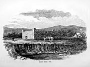
The Battle of Wyoming, also known as the Wyoming Massacre, was a military engagement during the American Revolutionary War between Patriot militia and a force of Loyalist soldiers and Iroquois warriors. The battle took place in the Wyoming Valley of Pennsylvania on July 3, 1778 in what is now Luzerne County. The result was an overwhelming defeat for the Americans. There were roughly 300 Patriot casualties, many of whom were killed by the Iroquois as they fled the battlefield or after they had been taken prisoner.
According to historian Kevin Kenny, the Paxton Boys were Pennsylvania's most aggressive colonists. This group of vigilantes from Lancaster and Cumberland counties formed in 1763 to defend themselves from attacks by the Lenape and Shawnee during Pontiac's War. They are infamous for the murder of twenty Susquehannock in December 1763 during the events known as the Conestoga Massacre. In February 1764, the Paxton Boys marched on Philadelphia with the intent of murdering the Moravian Lenape and Mohican who had been moved there for their protection. They dispersed at Germantown after meeting with a delegation headed by Benjamin Franklin. Members of the group led by Lazarus Stewart later supported settlers from Connecticut in the Wyoming Valley during the Pennamite-Yankee Wars and Revolutionary War.

The Wyoming Valley is a historic industrialized region of Northeastern Pennsylvania. The region is historically notable for its influence in helping fuel the American Industrial Revolution with its many anthracite coal-mines. As a metropolitan area, it is known as the Scranton/Wilkes-Barre metropolitan area, after its principal cities, Scranton and Wilkes-Barre. With a population of 567,559 as of the 2020 United States census, it is the fifth-largest metropolitan area in Pennsylvania, after the Delaware Valley, Greater Pittsburgh, the Lehigh Valley, and the Harrisburg–Carlisle metropolitan statistical areas.

The Pennamite–Yankee Wars or Yankee–Pennamite Wars were a series of conflicts consisting of the First Pennamite War (1769–1770), the Second Pennamite War (1774), and the Third Pennamite War (1784), in which settlers from Connecticut (Yankees) and Pennsylvania (Pennamites) disputed for control of the Wyoming Valley along the North Branch of the Susquehanna River. Both colonies and later states declared that their original land grants gave them control of this territory.
Zebulon Butler was an American military officer and politician from Connecticut who served with the Continental Army during the Revolutionary War. He represented the Wyoming Valley in the Connecticut Assembly. At the time, the territory was claimed both by Connecticut and by Pennsylvania, and was nominally under the former's jurisdiction.
Captain Lazarus Stewart was an 18th-century Pennsylvanian frontiersman, a leader of the Paxton Boys, and a prominent commander on the Yankee side in the Pennamite–Yankee War. He met his death during the Revolutionary War in battle with Loyalists and Iroquois at the Battle of Wyoming.

Greater Pittston is a 65.35 sq mi (169.3 km2) region in Luzerne County, Pennsylvania, in reference to the area in and around Pittston. As of 2010, the total population of Greater Pittston is 48,020. This region includes Avoca, Dupont, Duryea, Exeter Boro, Exeter Township, Hughestown, Jenkins Township, Laflin, Pittston Township, West Pittston, West Wyoming, Wyoming, and Yatesville.

The northern theater of the American Revolutionary War after Saratoga consisted of a series of battles between American revolutionaries and British forces, from 1778 to 1782 during the American Revolutionary War. It is characterized by two primary areas of activity. The first set of activities was based around the British base of operations in New York City, where each side made probes and counterprobes against the other's positions that sometimes resulted in notable actions. The second was essentially a frontier war in Upstate New York and rural northern Pennsylvania that was largely fought by state militia companies and some Indian allies on the American side, and Loyalist companies supported by Indians, British Indian agents, and occasionally British regulars. The notable exception to significant Continental Army participation on the frontier was the 1779 Sullivan Expedition, in which General John Sullivan led an army expedition that drove the Iroquois out of New York. The warfare amongst the splinters of the Iroquois Six Nations were particularly brutal, turning much of the Indian population into refugees.

The Big Runaway was a mass evacuation in June and July 1778 of settlers from the frontier areas of north central Pennsylvania during the American Revolutionary War. A major campaign by Loyalists and Native Americans allied with the British devastated the small communities on the northern and western branches of the Susquehanna River, prompting local militia leaders to order the evacuation. Most of the settlers relocated to Fort Augusta at modern-day Sunbury at the confluence of the North and West Branches of the Susquehanna River, while their abandoned houses and farms were all burnt.
Fort Antes was a stockade surrounding the home of Colonel John Henry Antes, built circa 1778 in Revolutionary Pennsylvania in the United States. The fort was built under the direction of Colonel Antes, who was a member of the Pennsylvania militia. It was on the east side of Antes Creek, overlooking and on the left bank of the West Branch Susquehanna River on a plateau in Nippenose Township south of modern day Jersey Shore in western Lycoming County. The local militia held the fort for a short period of time until it was ordered to abandon Fort Antes during the Big Runaway by Colonel Samuel Hunter. Despite being abandoned and attempts by the attacking British forces to burn it down, Fort Antes was one of only two structures in the valley to survive the Big Runaway.

Forty Fort Meetinghouse is a historic meeting house at River Street and Wyoming Avenue in the Old Forty Fort Cemetery in Forty Fort, Luzerne County, Pennsylvania. It was built in 1806–08 in a New England meeting house style with white clapboard siding and was added to the National Register of Historic Places in 1988.
Nathan Waller was an American Revolutionary War soldier. He was originally from Connecticut, but became an early settler in the Wyoming Valley region of present-day Pennsylvania. He fought in the American Revolutionary War, reaching the rank of captain. Later, he became a relatively prosperous farmer and landowner.