Foss or FOSS may refer to:

Kleppe is the administrative centre of Klepp municipality in Rogaland county, Norway. The village is located about halfway between the lakes Orrevatnet and Frøylandsvatnet. The village of Bore lies about 3 kilometres (1.9 mi) northwest of Kleppe and the village of Klepp stasjon lies about 3 kilometres (1.9 mi) to the east. The town of Bryne lies about 5 kilometres (3.1 mi) to the south and the city of Sandnes is located about 12 kilometres (7.5 mi) to the northeast. Klepp Church is located in Kleppe.

Ålgård is the administrative centre of Gjesdal municipality in Rogaland county, Norway. The village is located along the European route E39 highway, about 10 kilometres (6.2 mi) southeast of the city of Sandnes in the Jæren district of the county. The village includes the neighborhoods of Ålgård, Bærland, Fiskebekk, Opstad and Solås. The large lake Edlandsvatnet lies on the south side of the village, emptying into the river Figgjoelva which runs northwest to Sandnes.

Kvernaland is a village in Rogaland county, Norway. The village is located along the north end of the lake Frøylandsvatnet. The village is located in both the municipalities of Klepp and Time. The eastern part of the village is known as Orstad and the western part of the village is known as Frøyland or simply as Kvernaland. The village of Klepp stasjon lies just southwest of the village on the west side of the lake and the small village of Foss Eikjeland lies just north of the village, along the river Figgjo.

Figgjo is a borough of the city of Sandnes in Rogaland county, Norway. The borough is located in the southern part of the city. It has a population (2016) of 2,213. The borough is mostly rural, but the village of Figgjo lies in the southern edge of the municipality. About 90% of the population of the borough lives in the village of Figgjo.
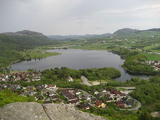
Frøylandsvatnet is a lake in the municipality of Sandnes in Rogaland county, Norway. The 0.48-square-kilometre (120-acre) lake lies on the south side of the village of Hommersåk, about 10 kilometres (6.2 mi) northeast of the city of Sandnes. The lake empties into a small river that runs out of the north end of the lake. The river runs through Hommersåk into an arm of the Gandsfjorden.
Vatne is a village in Sandnes municipality in Rogaland county, Norway. The village lies in the borough of Hana, just about 3 kilometres (1.9 mi) northeast of the city centre of Sandnes. It is considered a part of the Stavanger/Sandnes urban area. The 0.5-square-kilometre (120-acre) village has a population (2015) of 936, giving the village a population density of 1,872 inhabitants per square kilometre (4,850/sq mi). The Vatneleiren military base is located in Vatne.

Høle is a borough and village in the western part of Sandnes municipality in Rogaland county, Norway. It is located along the Høgsfjorden in the eastern part of the municipality. The area was historically a part of the municipality of Høle. Høle Church and Høle School are both located in the village. The Norwegian National Road 13 runs through the village and the borough.

Hommersåk is a village in Sandnes municipality in Rogaland county, Norway. The village is located in the borough of Riska in the northern part of the municipality. It is situated about 12 kilometres (7.5 mi) northeast of the city centre of Sandnes, along the shore of the Riskafjorden, an arm off the main Gandsfjorden. The 2.14-square-kilometre (530-acre) village has a population (2015) of 6,312; giving the village a population density of 2,950 inhabitants per square kilometre (7,600/sq mi).
Flassavatnet is a lake in Rogaland county, Norway. The lake lies on the border of the municipalities of Gjesdal and Sandnes. The 0.9243-square-kilometre (0.3569 sq mi) lake sits about 1 kilometre (0.62 mi) north of the large village of Ålgård, not far north of the lakes Edlandsvatnet and Limavatnet. The lake is a reservoir with a small dam on the southern edge of the lake. The water level is kept at about 177 metres (581 ft) above sea level. The reservoir holds about 900,000 cubic metres.

Figgjoelva or Figgjo is a river in Rogaland county, Norway. The 26.4-kilometre (16.4 mi) long river begins at the lake Edlandsvatnet in the village of Ålgård in Gjesdal municipality. It then heads north into the municipality of Sandnes before heading west. For a while, the river forms the municipal border between Sandnes and Time and between Sandnes and Klepp. The last part of the river runs west through Klepp before emptying into the North Sea. The Feistein Lighthouse lies on a small island, just northwest of the mouth of the river. The main part of the river is 26.4 kilometres (16.4 mi), but if you include the tributaries, the river is about twice as long at 45 kilometres (28 mi).

The Ålgård Line is a closed, but not abandoned, railway line between Ganddal and Ålgård in Rogaland, Norway. The 12.24-kilometer (7.61 mi) line was built as a narrow gauge branch line of the Jæren Line by the Norwegian State Railways (NSB) and opened in 1924. It runs through the villages of Foss-Eikeland and Figgjo in Sandnes to Ålgård in Gjesdal. Several proposals were made for the Ålgård Line to become the first part of the main line from Stavanger to Oslo, but instead the Sørlandet Line was connected to the Jæren Line in 1944. At the same time, the Ålgård Line was upgraded to standard gauge.

Solakrossen or Sola is the administrative center of Sola municipality in Rogaland county, Norway. The village is located at the south end of the Hafrsfjorden on the Stavanger Peninsula, just northwest of the city of Sandnes. The large Stavanger Airport, Sola is located on the west side of the village. The village of Sørnes lies just to the north. Sola Church lies on the far western edge of Solakrossen. The population of Solakrossen is about 10,000, but the population is not separately tracked since it is part of the Stavanger/Sandnes urban area. The newspaper Solabladet has been published in Solakrossen since 1991.

Lura is a borough of the city of Sandnes in Rogaland county, Norway. The 8-square-kilometre (3.1 sq mi) borough lies in the northwestern part of the city, just north of the city centre of Sandnes and just south of the city of Stavanger. The borough has a population (2016) of 8,605. Lura Church is the main church for the borough. Lura school is one of the primary schools there, with grades from 1-7.

Riska is a borough of the city of Sandnes in Rogaland county, Norway. The borough sits in the northern part of the municipality, northeast of the city centre of Sandnes. The Gandsfjorden flows along the west side of the borough and the Høgsfjorden runs along the northeast side. The 66.5-square-kilometre (25.7 sq mi) borough has a population (2016) of 7,294.

Austrått is a borough of the city of Sandnes in Rogaland county, Norway. The 6-square-kilometre (2.3 sq mi) borough lies just southeast of the main city centre of Sandnes. The borough has a population (2016) of 8,251. Prior to 2011, the borough of Bogafjell was a part of Austrått, but it was split off to form its own borough at that time. Høyland Church is located in Austrått.


