Foul Bay, Barbados

Last updated
Barbadians exercising at Foul Bay in 1955 Barbados Flip (3079693839).jpg
Barbadians exercising at Foul Bay in 1955

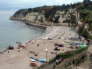
Foul Bay refers to a bay, beach, and village in Saint Philip Parish, alongside the southeast coast of Barbados.

Barbados Country in the Caribbean

Barbados is an island country in the Lesser Antilles of the West Indies, in the Caribbean region of North America. It is 34 kilometres in length and up to 23 km (14 mi) in width, covering an area of 432 km2 (167 sq mi). It is situated in the western area of the North Atlantic and 100 km (62 mi) east of the Windward Islands and the Caribbean Sea; therein, Barbados is east of the Windwards, part of the Lesser Antilles, roughly at 13°N of the equator. It is about 168 km (104 mi) east of both the countries of Saint Lucia and Saint Vincent and the Grenadines and 180 km (110 mi) south-east of Martinique and 400 km (250 mi) north-east of Trinidad and Tobago. Barbados is outside the principal Atlantic hurricane belt. Its capital and largest city is Bridgetown.

Foul Bay Beach is used for excursions, picnics, [1] wedding ceremonies, and receptions by locals and visitors to the island. It is also a nesting area for hawksbill sea turtles. [2]

Hawksbill sea turtle Species of marine reptile in the family Chelonidae

The hawksbill sea turtle is a Critically Endangered sea turtle belonging to the family Cheloniidae. It is the only extant species in the genus Eretmochelys. The species has a worldwide distribution, with Atlantic and Indo-Pacific subspecies—E. i. imbricata and E. i. bissa, respectively.

There are different explanations of how the area got its name. Up to the mid-1950s fishermen used to sell their catch on Foul Bay Beach. The fish were de-scaled and gutted on the spot. The smell was foul, hence the name.[ citation needed ] Another story claims the name is a misspelling of "Fowl" Bay, and that the area once hosted many migrating birds. [1] Late 18th and early 19th Century Documents pertaining to British slavery in Barbados show the area's name as both "Foul" and "Fowl." [3]

Barbados Slave Code 1661 slave law in English colony of Barbados

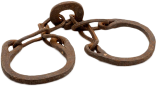
The Barbados Slave Code of 1661 was a law passed by the colonial English legislature to provide a legal basis for slavery in the Caribbean island of Barbados. The code's preamble, which stated that the law's purpose was to "protect them [slaves] as we do men's other goods and Chattels", established that black slaves would be treated as chattel property in the island's court. These codes identified Irish indentured servants working in Barbados providing stark contrast to the actual slaves "imported from the Americas and Africa." The Irish were to work a period for 2 years up to 7 years only. At such point the Irish would have the ability to buy and own property and pursue life with all liberties afforded them. The slaves imported from the Americas and Africa were enslaved for life as were all of their offspring and all in their lineage in perpetuity.

As the local government developed the fishing industry, designated fish markets were set up in Oistins, Speightstown, and Bridgetown. Foul Bay Beach was cleaned by the National Conservation Commission, and it continues to be maintained by a team from the Commission who remove leaves, seaweed, and litter from the beach.[ citation needed ]

Fish market marketplace for fish products

A fish market is a marketplace for selling fish products. It can be dedicated to wholesale trade between fishermen and fish merchants, or to the sale of seafood to individual consumers, or to both. Retail fish markets, a type of wet market, often sell street food as well.

Oistins Town in Christ Church, Barbados

Oistins, is a coastal area located in the country of Barbados. Situated centrally along the coastline of the parish of Christ Church, Through Statutory Instrument (S.I) 1984 No. 141, Road Traffic Act, CAP. 295, ROAD TRAFFIC REGULATIONS, and under Schedule Section # 6: The Boundaries of Bridgetown, Speightstown, Holetown and Oistin are cited as follows: 4) "Oistins: The section of Highway 7 from its junction with Cane Vale Road to its junction with Keizer Hill Road." The area operates mostly as a fishing village and a tourist hang out, containing a collection of bars, rumshops, and shopping centers.

Speightstown Town in Saint Peter, Barbados

Speightstown, also known as Little Bristol, is the second largest town centre of Barbados. It is situated 12 miles (19 km) north of the capital city of Bridgetown, in the northern parish of Saint Peter.

Coordinates: 13°06′N59°27′W / 13.100°N 59.450°W / 13.100; -59.450

Geographic coordinate system Coordinate system

A geographic coordinate system is a coordinate system that enables every location on Earth to be specified by a set of numbers, letters or symbols. The coordinates are often chosen such that one of the numbers represents a vertical position and two or three of the numbers represent a horizontal position; alternatively, a geographic position may be expressed in a combined three-dimensional Cartesian vector. A common choice of coordinates is latitude, longitude and elevation. To specify a location on a plane requires a map projection.

Related Research Articles

Slaughter Beach, Delaware Town in Delaware, United States

Slaughter Beach is a town in Sussex County, Delaware, United States. The population was 207 at the 2010 census, an increase of 4.5% over the past decade. It is part of the Salisbury, Maryland-Delaware Metropolitan Statistical Area.

Panama City Beach, Florida City in Florida, United States

Panama City Beach is a resort town in Bay County, Florida, United States, on the Gulf of Mexico coast. As of the 2010 census it had a population of 12,018. The city is often referred to under the umbrella term of "Panama City". Panama City Beach's slogan is "The World's Most Beautiful Beaches" due to the unique, sugar-white sandy beaches of northwest Florida.

Destin, Florida City in Florida

Destin is a city located in Okaloosa County, Florida. It is a principal city of the Crestview–Fort Walton Beach–Destin, Florida, metropolitan area.

Clearwater, Florida City in Florida, United States

Clearwater is a city located in Pinellas County, Florida, United States, northwest of Tampa and St. Petersburg. To the west of Clearwater lies the Gulf of Mexico and to the southeast lies Tampa Bay. As of the 2010 census, the city had a population of 107,685. Clearwater is the county seat of Pinellas County and is the smallest of the three principal cities in the Tampa-St. Petersburg-Clearwater metropolitan area, most commonly referred to as the Tampa Bay Area.

Tobago autonomous island in the Republic of Trinidad and Tobago

Tobago is an island within the Republic of Trinidad and Tobago. It is located 35 kilometres (22 mi) northeast of the mainland of Trinidad and southeast of Grenada, about 160 kilometres (99 mi) off the coast of northeast Venezuela. According to the earliest English-language source cited in the Oxford English Dictionary, Tobago bore a name that has become the English word tobacco. The official bird of Tobago is the cocrico.

Lyme Regis Coastal town in Dorset, England

Lyme Regis is a town in West Dorset, England, 25 miles (40 km) west of Dorchester and 25 miles (40 km) east of Exeter. Styled "The Pearl of Dorset", it lies at Lyme Bay on the English Channel coast at the Dorset–Devon border. It is noted for fossils found in cliffs and beaches on the Heritage Coast or Jurassic Coast, a World Heritage Site. The harbour wall – known as "The Cobb" – appears in Jane Austen's novel Persuasion, the John Fowles novel The French Lieutenant's Woman, and the 1981 film of that name, which was partly shot in the town. A former mayor and MP was Admiral Sir George Somers, who founded the English colonial settlement of Somers Isles, now Bermuda, where Lyme Regis is twinned with St George's. In July 2015, Lyme Regis also joined Jamestown, Virginia, in a Historic Atlantic Triangle with St George's. The 2011 Census gave the parish and electoral ward a population of 3,671.

Parksville is a city on Vancouver Island in British Columbia, Canada. The city lies along Highway 19A, 37 kilometres northwest of Nanaimo, 48 kilometres east of Port Alberni and 7 kilometres southeast of Qualicum Beach. The majority of Parksville's land base lies between Englishman River and French Creek, although a substantial portion of the city lies east of Englishman River, along the western shores of Craig Bay. As of the 2016 Census, Parksville's population was 12,514, representing a 4.5% increase over the 2011 Census.

Beer, Devon village in United Kingdom

Beer is a village and civil parish in the East Devon district of Devon, England. The village faces Lyme Bay and is a little over 1 mile (1.6 km) west of the town of Seaton. It is situated on Jurassic Coast World Heritage Site and its picturesque cliffs, including Beer Head, form part of the South West Coast Path.

Bruce Peninsula peninsula in Southern Ontario, Canada

The Bruce Peninsula is a peninsula in Ontario, Canada, that lies between Georgian Bay and the main basin of Lake Huron. The peninsula extends roughly northwestwards from the rest of Southwestern Ontario, pointing towards Manitoulin Island, with which it forms the widest strait joining Georgian Bay to the rest of Lake Huron. The Bruce Peninsula contains part of the geological formation known as the Niagara Escarpment.

Exuma Place in Bahamas

Exuma is a district of the Bahamas, consisting of over 365 islands, also called cays.

Fistral Beach beach on north coast of Cornwall

Fistral Beach is in Fistral Bay on the north coast of Cornwall, England, United Kingdom. It is situated half-a-mile west of Newquay at grid reference SW 797 620.

Hamilton Harbour

Hamilton Harbour, formerly known as Burlington Bay, lies on the western tip of Lake Ontario, bounded on the northwest by the City of Burlington, on the south by the City of Hamilton, and on the east by Hamilton Beach and Burlington Beach. It is joined to Cootes Paradise by a narrow channel formerly excavated for the Desjardins Canal. Within Hamilton itself, it is referred to as "Hamilton Harbour", "The Harbour" and "The Bay". The bay is naturally separated from Lake Ontario by a sand bar. The opening in the north end was filled in and channel cut in the middle for ships to pass. The Port of Hamilton is on the Hamilton side of the harbour.

Laganas Place in Greece

Laganas is a village and a former municipality on the island of Zakynthos, Ionian Islands, Greece. Since the 2011 local government reform it is part of the municipality Zakynthos, of which it is a municipal unit. The municipal unit Laganas covers the southernmost part of Zakynthos. Its municipal seat was the town of Pantokratoras. The municipal unit of Laganas has a land area of 74.104 km². Its largest towns are Mouzaki, Lithakia, Pantokratoras, Kalamaki, Laganas, and Keri. The central and eastern part of the municipal unit are flat, but there are hills up to 450 m elevation in the west. The Zakynthos International Airport lies in the eastern part of the municipal unit, near Kalamaki. The beach village Laganas, part of the community of Pantokratoras, is on the southeastern coast. A large part of Laganas is a national park, established for the protection of turtles.

Freshwater Bay is located between Paynes Bay and Carlisle Bay in Bridgetown, in the southwest of Barbados. Its name comes from the large number of streams that deposit fresh water into the ocean at the location.

Segway polo

Segway polo is a team sport which started to gain some measure of popularity after being played by members of the Bay Area Segway Enthusiasts Group in 2004. The Bay Area SEG was not the first to play polo on a Segway HT; a team sponsored by Mobile Entertainment played in the Hubert H. Humphrey Metrodome at a Minnesota Vikings halftime show in 2003 although the Bay Area SEG members were not aware of this match at the time they first played the sport. Segway polo was developed as it is played today by the members of the Bay Area SEG and other groups and teams that have joined subsequently.

Miami Beach, Barbados

Miami Beach, Barbados, near the town of Oistins, is a popular sandy beach in Barbados. It is located on the south coast of the island, with usually calm waters and brilliant sunset views. On its north side is Enterprise Beach, a much more sheltered bay popular with families. Miami Beach is popular with both locals and tourists. Each morning local seniors swim in the sea and exercise on the beach. Also a great break for bodysurfing and bodyboarding.

Lovers Point State Marine Reserve

Lovers Point State Marine Reserve (SMR) is one of four small marine protected areas located near the cities of Monterey and Pacific Grove, at the southern end of Monterey Bay on California’s central coast. The four MPAs together encompass 2.96 square miles (7.7 km2). The SMR protects all marine life within its boundaries. Fishing and take of all living marine resources is prohibited.

Soquel Canyon State Marine Conservation Area

Soquel Canyon State Marine Conservation Area (SMCA) is an offshore marine protected area in Monterey Bay. Monterey Bay is on California’s central coast with the city of Monterey at its south end and the city of Santa Cruz at its north end. The SMCA covers 23.41 square miles (60.6 km2). Within the SMCA, fishing and taking of any living marine resources is prohibited except the commercial and recreational take of pelagic finfish.

George Washington House (Barbados) house where young George Washington and his brother stayed for a time

George Washington House in Barbados is a historic house where the future first U.S. President George Washington visited, in 1751. He was 19 years old at the time and traveling with his ailing half-brother, Lawrence Washington. In 2011, the property was designated as a UNESCO protected property within the World Heritage Site of Historic Bridgetown and its Garrison area.

References

  1. 1 2 Guide, Barbados.org Travel. "Barbados beaches: Foul Bay". barbados.org. Retrieved 2018-02-16.
  2. "Foul Bay - Barbados Pocket Guide". www.barbadospocketguide.com. Retrieved 2018-08-23.
  3. "Details of Estate | Legacies of British Slave-ownership". www.ucl.ac.uk. Retrieved 2018-08-23.