
The Arctic Archipelago, also known as the Canadian Arctic Archipelago, is a group of islands north of the Canadian mainland.
This is a list of the extreme points of Ireland – the points that are farthest north, south, east or west in Ireland. It includes the Republic of Ireland and Northern Ireland.

Gorom-Gorom is a town in northern Burkina Faso. Its name translates as "you sit down, (and) we'll sit down", reminiscent of its role as an important crossroads in the Sahel. It is the capital of Oudalan Province.
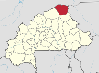
Oudalan is one of the 45 provinces of Burkina Faso, located in its Sahel Region. Its capital is Gorom-Gorom. The 2006 census reported 197,240 people living in the province.

Saint Andrew is an administrative parish of Saint Vincent and the Grenadines, on the island of Saint Vincent. Its capital is Layou.

Botopasi, also spelled Boto-Pasi, is a Saamaka village in Suriname.

Kurima is a village and municipality in the Bardejov District in the Prešov Region of north-east Slovakia.

Barbadillo del Pez is a municipality and town located in the province of Burgos, Castile and León, Spain. According to the 2007 census (INE), the municipality has a population of 82 inhabitants.
Cabezón de la Sierra is a municipality located in the province of Burgos, Castile and León, Spain. According to the 2004 census (INE), the municipality has a population of 67 inhabitants.
Cañamaque is a municipality located in the province of Soria, Castile and León, Spain. According to the 2004 census (INE), the municipality has a population of 42 inhabitants.

Pompoï is a department or commune of Balé Province in southern Burkina Faso. Its capital lies at the town of Pompoï. According to the 1996 census the department has a total population of 10,613.
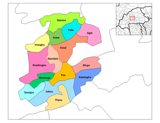
Poa is a department or commune of Boulkiemdé Province in central Burkina Faso. As of 2005 it has a population of 30,406. Its capital lies at the town of Poa.
Loaba is a town in the Bittou Department of Boulgou Province in south-eastern Burkina Faso. As of 2005, the town has a population of 3,518.
SM UC-33 was a German Type UC II minelaying submarine or U-boat in the German Imperial Navy during World War I. The U-boat was ordered on 29 August 1915 and was launched on 26 August 1916. She was commissioned into the German Imperial Navy on 25 September 1916 as SM UC-33. In seven patrols UC-33 was credited with sinking 36 ships, either by torpedo or by mines laid. UC-33 was shelled and then rammed by patrol boat PC61 captained by Frank Worsley at position 51°55′N6°14′W in St. George's Channel on 26 September 1917.
Chã Grande is a city located in the state of Pernambuco, Brazil. Located at 80 km away from Recife, capital of the state of Pernambuco. Has an estimated population of 17.924 inhabitants.
Empire Brutus was a 7,233 GRT cargo ship which was built in 1941 by J. L. Thompson & Sons Ltd for the Ministry of War Transport (MoWT). Although twice damaged by enemy action, she survived the war. Postwar she was sold into merchant service, being renamed Vergmor, Southgate and Fatih, serving until scrapped in 1968.

Boven Saramacca is a resort in Suriname, located in the Sipaliwini District. Its population at the 2012 census was 1,427. The dominant geographical feature of this resort is the Saramacca River.
Skujaine is a village in Penkule Parish and Dobele Municipality in the historical region of Zemgale, and the Zemgale Planning Region in Latvia.
Grañón is a village in the province and autonomous community of La Rioja, Spain. The municipality covers an area of 31.01 square kilometres (11.97 sq mi) and as of 2011 had a population of 307 people.


