This article relies largely or entirely on a single source .(May 2022) |

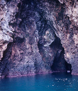
Fox Cave is a cavern in the village of Shmankivtsi, Chortkiv Raion, Ternopil Oblast, Ukraine. [1]
This article relies largely or entirely on a single source .(May 2022) |
Fox Cave is a cavern in the village of Shmankivtsi, Chortkiv Raion, Ternopil Oblast, Ukraine. [1]
Cadastral number - № 27, registered in the Ternopil Speleological Club "Podillia". [2] [3]
The cave has been known since ancient times. The description and survey were made on April 27, 1965 by speleologists of the Ternopil club "Podillya" Serhii Budennyi, Valentyn Piatapal, Ihor Martynyshyn. [2] [3]
By type the cavity is labyrinthine and erosive-corrosive. [2] [3]
The entrance to the cave was located on the northern slope of a small ravine on the left bank of the river Nichlava. Azimuth binding is the church with. Shmankivchyky - 305 ° at a distance of 2 kilometers. [2] [3] [4]
The total length of the passages is 34 m, [5] its area is 46 km and the volume is 70 m. The width of the passages in the cave is from 0.9 to 2.5 m, and the height from 0.5 to 1.8 meters. [2] [3]
The cave is laid in gray sandstone of gray hue, it is horizontal, there are no cracks in the ceiling and walls. According to the genesis of formation, this cavity is of the corrosion-suffusion type. Clay deposits were observed at the bottom. In cross section it is flat, sometimes domed, had three dead ends, which fell sharply, but their end is not traced. [2] [3]
The cave is wet, but did not have constant watercourses, which has its own constant microclimatic regime, except for the entrance, which depended on weather conditions and seasons. Refers to small caves, which are most often inhabited in ancient times by man. Unfortunately, the entrance to the cave was now covered with soil, which gradually sank down in the process of water erosion. [2] [3]

A cave or cavern is a natural void in the ground, specifically a space large enough for a human to enter. Caves often form by the weathering of rock and often extend deep underground. The word cave can refer to smaller openings such as sea caves, rock shelters, and grottos, that extend a relatively short distance into the rock and they are called exogene caves. Caves which extend further underground than the opening is wide are called endogene caves.

Blanchard Springs Caverns is a cave system located in the Ozark–St. Francis National Forest in Stone County in northern Arkansas, USA, 2 miles (3.2 km) off Highway 14 a short distance north of Mountain View. It is the only tourist cave owned by the United States Forest Service and the only one owned by the federal government outside the National Park System. Blanchard Springs Caverns is a three-level cave system, all of which can be viewed on guided tours.

A chaitya, chaitya hall, chaitya-griha, refers to a shrine, sanctuary, temple or prayer hall in Indian religions. The term is most common in Buddhism, where it refers to a space with a stupa and a rounded apse at the end opposite the entrance, and a high roof with a rounded profile. Strictly speaking, the chaitya is the stupa itself, and the Indian buildings are chaitya halls, but this distinction is often not observed. Outside India, the term is used by Buddhists for local styles of small stupa-like monuments in Nepal, Cambodia, Indonesia and elsewhere. In Thailand a stupa, not a stupa hall, is called a chedi. In the historical texts of Jainism and Hinduism, including those relating to architecture, chaitya refers to a temple, sanctuary or any sacred monument.

The Marble Arch Caves are a series of natural limestone caves located near the village of Florencecourt in County Fermanagh, Northern Ireland. The caves are named after the nearby Marble Arch, a natural limestone arch at the upstream end of Cladagh Glen under which the Cladagh River flows. The caves are formed from three rivers draining off the northern slopes of Cuilcagh mountain, which combine underground to form the Cladagh. On the surface, the river emerges from the largest karst resurgence in Ireland, and one of the largest in the United Kingdom. At 11.5 kilometres (7.1 mi) the Marble Arch Caves form the longest known cave system in Northern Ireland, and the karst is considered to be among the finest in the British Isles.
A sea cave, also known as a littoral cave, is a type of cave formed primarily by the wave action of the sea. The primary process involved is erosion. Sea caves are found throughout the world, actively forming along present coastlines and as relict sea caves on former coastlines. Some of the largest wave-cut caves in the world are found on the coast of Norway, but are now 100 feet or more above present sea level. These would still be classified as littoral caves. By contrast, in places like Thailand's Phang Nga Bay, solutionally formed caves in limestone have been flooded by the rising sea and are now subject to littoral erosion, representing a new phase of their enlargement.

The Barabar Hill Caves are the oldest surviving rock-cut caves in India, dating from the Maurya Empire, some with Ashokan inscriptions, located in the Makhdumpur region of Jehanabad district, Bihar, India, 24 km (15 mi) north of Gaya.

The Belum Caves, located in Nandyala district of Andhra Pradesh's Rayalaseema region, is the second largest cave system on the Indian subcontinent, known for its speleothems, such as stalactite and stalagmite formations. The Belum Caves have long passages, galleries, spacious caverns with fresh water and siphons. This cave system was formed over the course of tens of thousands of years by the constant flow of underground water from the now-disappeared river Chitravathi. The cave system reaches its deepest point at the point known as Pataalaganga. Belum Caves have a length of 3,229 m (10,593.8 ft), making them the second largest caves on the Indian Subcontinent after the Krem Liat Prah caves in Meghalaya. It is one of the centrally protected Monuments of National Importance.

Deer Cave, located near Miri, Sarawak, Malaysia, is a show cave attraction of Gunung Mulu National Park. It was surveyed in 1961 by G. E. Wilford of the British Borneo Geological Survey, who predicted that Mulu would yield many more caves in the future. The cave, which is also known as Gua Payau or Gua Rusa by the local Penan and Berawan people, is said to have received its name because of the deer that go there to lick salt-bearing rocks and shelter themselves.

The Nyero rock paintings are located in eastern Uganda in Kumi District, 8 km (5.0 mi) west of Kumi town, about 250 km (155.3 mi) from the capital city Kampala. The Nyero rock paintings are among the most important rock art in Uganda.

High Pasture Cave is an archaeological site on the island of Skye, Scotland. Human presence is documented since the Mesolithic, and remains, including Iron Age structures, point to ritual veneration of either the landscape or deities associated with the place. The cave system extends to about 320 metres of accessible passages

Short Drop Cave and Gavel Pot are different entrances into the same cave system on Leck Fell, in Lancashire, England. The main top entrance, Short Drop Cave, is a small hole in a fenced off shakehole near the main stream sink; Gavel Pot, a window into the system, is a large fenced shakehole some 40-metre (130 ft) deep requiring tackle to descend. There are two other smaller entrances into Short Drop Cave. At its base the system links via a sump with Lost Johns' Cave, and is part of the Three Counties System, an 87 kilometres (54 mi) cave system which spans the borders of Cumbria, Lancashire, and North Yorkshire.

Death's Head Hole is a cave on Leck Fell, in Lancashire, England. Its entrance is a 64-metre (210 ft) deep shaft. It leads into Lost Johns' Cave and is part of the Three Counties System, an 87-kilometre (54 mi) cave system which spans the borders of Cumbria, Lancashire, and North Yorkshire.

Atlantida is a karst cave in Ukraine, most famous for its unusual geology, rare formations, and pristine condition. It is located at the bank of the river Zbruch in Kamianets-Podilskyi Raion of Khmelnytskyi Oblast, close to Zavallya village. The cave is 2525 m long and 18 m deep, with 4440 m² area. Subordinated to the Tourism and Excursions Council of Khmelnytskyi Oblast, the cave is a part of the Podilski Tovtry National Nature Park.

Grotto Calgeron, also known as the GB Trener cave, is a natural cavity that is located near the village of Grigno in Valsugana in Trentino.

The Long Kin East Cave - Rift Pot system is a limestone cave system on the southern flanks of Ingleborough, North Yorkshire in England lying within the designated Ingleborough Site of Special Scientific Interest. Long Kin East Cave starts as a long meandering stream passage but then plummets down a 58-metre (190 ft) deep shaft when it meets a shattered fault into which Rift Pot also descends. At the bottom, the stream flows through some low canals and sumps, to eventually emerge at Austwick Beck Head in Crummackdale.

The Radochów Cave is a karst cave in lenticular marble. It is situated in the valley of the Jaskiniec Stream, at the foot of Bzowiec in the Golden Mountains of, near the village of Radochów, Poland.

Volodymyr Dobrianskyi is a Ukrainian scientist, archaeologist, historian, speleologist, and researcher of antiquities, fortifications and toponymy. He became a member of the Ukrainian Society for the Protection of Historical and Cultural Monuments in 1981, the Shevchenko Scientific Society in 2000, and the National Union of Journalists of Ukraine from 2016 to 2020. He also co-founded the NGO "Alternative-Chortkiv". He also participated in liquidating the Chernobyl accident of the second category.

Shmankivtsi is a village in Ukraine, Ternopil Oblast, Chortkiv Raion, Zavodske settlement hromada. It is the administrative center of the former Shmankivska village council. Additionally, the village encompasses the former locality of Strusivka, which formed in the 18th century, possibly by the a member of the Struś coat of arms.
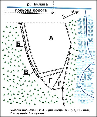
Shmankivtsi Castle is a lost defensive structure in the village of Shmankivtsi, Zavodske settlement hromada, Chortkiv District, Ternopil Oblast, Ukraine.
Kyrnychky is a cave located in the Ukrainian village of Horodok, Zalishchyky Hromada, Chortkiv Raion, Ternopil Oblast. It is located 700-800 meters northeast of the village. It belongs to the Nyzhnoseretska karst area.