
The geography of Canada describes the geographic features of Canada, the world's second largest country in total area.

The Trans-Canada Highway is a transcontinental federal-provincial highway system that travels through all ten provinces of Canada from the Pacific Ocean on the west to the Atlantic on the east. The main route spans 7,821 km (4,860 mi) across the country, one of the longest routes of its type in the world. The highway system is recognizable by its distinctive white-on-green maple leaf route markers, although there are small variations in the markers in some provinces.

Lynn Lake is a town in the northwest region of Manitoba, Canada, approximately 1,071 km (665 mi) from Winnipeg. The town is the fourth-largest town in Manitoba in terms of land area. It is centred on the original urban community of Lynn Lake, located at 56°51′06″N101°02′48″W. The town was named after Lynn Smith, chief engineer of Sherritt Gordon Mines Ltd. There are many outfitters in the Lynn Lake area. They offer services for most wilderness experiences, including sport fishing and bear and moose hunting.

The Hayes River is a river in Northern Region, Manitoba, Canada that flows from Molson Lake to Hudson Bay at York Factory. It was an historically important river in the development of Canada, and is today a Canadian Heritage River and the longest naturally flowing river in Manitoba.

Gillam is a town on the Nelson River in northern Manitoba, Canada. It is situated between Thompson and Churchill on the Hudson Bay Railway line. Many residents of Gillam are employed by Manitoba Hydro at three of Manitoba's largest hydro dams—Kettle Generating Station, Long Spruce Generating Station, and Limestone Generating Station— located within Gillam's boundaries.

Melita is a town located in the southwestern corner of the Canadian province of Manitoba. It is surrounded by the Rural Municipality of Arthur and occupies a bend of the Souris River. The population at the 2016 census was 1,042. It sits at the junction of Highways 3 and 83, approx. 320 km southwest of Winnipeg. Melita is known as the "Grasslands Bird Capital of Manitoba" and is located in Manitoba's banana belt.

The Texas Blackland Prairies are a temperate grassland ecoregion located in Texas that runs roughly 300 miles (480 km) from the Red River in North Texas to San Antonio in the south. The prairie was named after its rich, dark soil.

Médanos de Coro National Park is a Venezuelan national park located in the state of Falcón, near the city of Coro on the road that leads to Paraguaná. The National Park was created in 1974. The park is easily reached by bus or taxi from Coro.
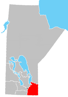
The Eastman Region--also known as Division No. 1-- is located in the south-eastern corner of the Canadian province of Manitoba. It is bounded on the north by the Winnipeg River and Lake Winnipeg, on the east by the Manitoba-Ontario border, on the south by the Canada–US border and on the west by the Red River. It is bordered on the north by the Northern Region, on the east by Northwestern Ontario on the south by the state of Minnesota, on the west by the Pembina Valley Region and the Interlake Region.
Norway House is a population centre of over 5,000 people some 30 km (19 mi) north of Lake Winnipeg, on the bank of the eastern channel of Nelson River, in the province of Manitoba, Canada. The population centre shares the name Norway House with the northern community of Norway House and Norway House 17, a First Nation reserve of the Norway House Cree Nation. Thus, Norway House has both a Chief and a Mayor.
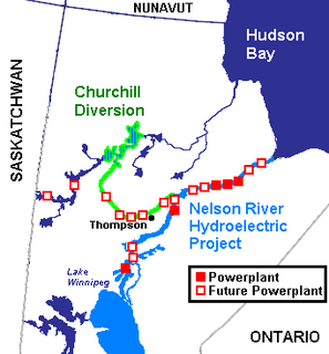
The Nelson River Hydroelectric Project refers to the construction of a series of dams and hydroelectric power plants on the Nelson River in Northern Manitoba, Canada. The project began to take shape in the late 1950s, with the planning and construction of the Kelsey dam and hydroelectric power station, and later was expanded to include the diversion of the upper Churchill River into the Nelson River and the transformation of Lake Winnipeg, the world's 11th largest freshwater lake, into a hydroelectric reservoir. The project is owned and operated by Manitoba Hydro, the electrical utility in the province.

The Northern Woods and Water Route is a 2,400-kilometre (1,500 mi) route through northern British Columbia, Alberta, Saskatchewan and Manitoba in Western Canada. As early as the 1950s community groups came together to establish a northern travel route; this was proposed as the Northern Yellowhead Transportation Route. The Northern Woods and Water Route Association was established in 1974, and encouraged promotion of the route with the promise of an increase in tourist travel. The route was designated in 1974 and is well signed throughout the connector highways. The route starts at Dawson Creek at the British Columbia Spirit River Highway 49 and ends at Winnipeg, Manitoba, running through the northern region of the western provinces. The Northern Woods and Water Route (NWWR) includes connector routes from west to east including British Columbia Highway 49, Alberta Highway 49, AB Hwy 2A, AB Hwy 2, AB Hwy 55, Saskatchewan Highway 55, SK Hwy 9, Manitoba Provincial Road 283, Manitoba Highway 10, MB PTH 5, MB PTH 68, MB PTH 6. The halfway point of the NWWR is approximately at Goodsoil, Saskatchewan.

The geography of Manitoba addresses the easternmost of the three prairie Canadian provinces, located in the longitudinal center of Canada. Manitoba borders on Saskatchewan to the west, Ontario to the east, Nunavut to the north, and the American states of North Dakota and Minnesota to the south. Although the border with Saskatchewan appears straight on large-scale maps, it actually has many right-angle corners that give the appearance of a slanted line. In elevation, Manitoba ranges from sea level on Hudson Bay to 2727 ft (831 m) on top of Baldy Mountain. The northern sixty percent of the province is on the Canadian Shield. The northernmost regions of Manitoba lie permafrost, and a section of tundra bordering Hudson Bay.
Provincial Trunk Highway 10 is a provincial primary highway located in the Canadian province of Manitoba.

Volcanology of Canada includes lava flows, lava plateaus, lava domes, cinder cones, stratovolcanoes, shield volcanoes, submarine volcanoes, calderas, diatremes, and maars, along with examples of more less common volcanic forms such as tuyas and subglacial mounds. It has a very complex volcanological history spanning from the Precambrian eon at least 3.11 billion years ago when this part of the North American continent began to form.
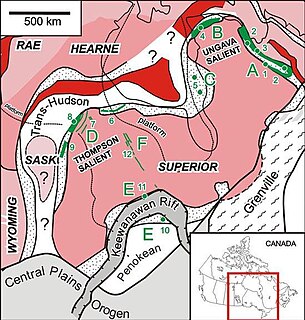
The Circum-Superior Belt is a widespread Paleoproterozoic large igneous province in the Canadian Shield of Northern, Western and Eastern Canada. It extends more than 3,400 km (2,100 mi) from northeastern Manitoba through northwestern Ontario, southern Nunavut to northern Quebec. Igneous rocks of the Circum-Superior Belt are mafic-ultramafic in composition, deposited in the Labrador Trough near Ungava Bay, the Cape Smith Belt near the southern shore of Hudson Strait and along the eastern shore of Hudson Bay in its northern portion; the Thompson and Fox River belts in the northwest and the Marquette Range Supergroup in its southern portion.

The volcanology of Eastern Canada includes the hundreds of volcanic areas and extensive lava formations in Eastern Canada. The region's different volcano and lava types originate from different tectonic settings and types of volcanic eruptions, ranging from passive lava eruptions to violent explosive eruptions. Eastern Canada has very large volumes of magmatic rock called large igneous provinces. They are represented by deep-level plumbing systems consisting of giant dike swarms, sill provinces and layered intrusions. The most capable large igneous provinces in Eastern Canada are Archean age greenstone belts containing a rare volcanic rock called komatiite.
The Mathias Colomb First Nation, Mathias Colomb Cree Nation (MCCN), Mathias Colomb (Cree) First Nation, Pukatawagan/Mathias Colomb Cree Nation is a remote northern Manitoba First Nations, located 210 km (130 mi) north of The Pas and 819 km (509 mi) northwest of Winnipeg, Manitoba, which had two reserves under its jurisdiction, Indian Rreserve (IR) 198 and IR No. 199. They are part of the Treaty 6 and the main community is at Pukatawagan and consists of 1,536.6 ha on the shore of Pukatawagan Lake and lies about 210 km (130 mi) north of The Pas. Their second reserve was the Highrock reserve (CSD) located on Highrock Lake, 30 km (19 mi) downstream from Pukatawagan, which was dissolved by 2006.

Southern Indian Lake is a large lake in Manitoba, Canada. It has an area of 2,247 km2 (868 sq mi) with a surface elevation of 258 m (846 ft).
Highway 57 and Provincial Trunk Highway 57 are two short highways in the Canadian provinces of Saskatchewan and Manitoba. It runs from Highway 5 east of Kamsack, Saskatchewan to the Saskatchewan – Manitoba border near Madge Lake, before ending at Provincial Trunk Highway 83. The combined highway is about 20.7 km (12.9 mi) in length, 19.2 km (11.9 mi) is in Saskatchewan and 1.5 km (0.9 mi) is in Manitoba.

