
Hydropower, also known as water power, is the use of falling or fast-running water to produce electricity or to power machines. This is achieved by converting the gravitational potential or kinetic energy of a water source to produce power. Hydropower is a method of sustainable energy production. Hydropower is now used principally for hydroelectric power generation, and is also applied as one half of an energy storage system known as pumped-storage hydroelectricity. Hydropower is an attractive alternative to fossil fuels as it does not directly produce carbon dioxide or other atmospheric pollutants and it provides a relatively consistent source of power. Nonetheless, it has economic, sociological, and environmental downsides and requires a sufficiently energetic source of water, such as a river or elevated lake. International institutions such as the World Bank view hydropower as a low-carbon means for economic development.

Appleton is a city in Outagamie, Calumet, and Winnebago counties in the U.S. state of Wisconsin. One of the Fox Cities, it is situated on the Fox River, 30 miles (48 km) southwest of Green Bay and 100 miles (160 km) north of Milwaukee. Appleton is the county seat of Outagamie County. As of the 2020 Census it had a population of 75,644, making it the sixth largest city in Wisconsin. Appleton is a part of the Fox Cities metropolitan area, the third largest in the state behind Milwaukee and Madison.

The Wisconsin River is a tributary of the Mississippi River in the U.S. state of Wisconsin. At approximately 430 miles long, it is the state's longest river. The river's name was first recorded in 1673 by Jacques Marquette as "Meskousing", which is rooted in the Algonquian languages used by the area's Native American tribes. The river's original meaning is obscure, but French explorers who followed in the wake of Marquette later modified the name to "Ouisconsin", and so it appears on Guillaume de L'Isle's map. This was simplified to "Wisconsin" in the early 19th century, before being applied to Wisconsin Territory and finally the state of Wisconsin.

The Fox River is a river in eastern Wisconsin in the Great Lakes region of the United States. It is the principal tributary of Green Bay, and via the Bay, the largest tributary of Lake Michigan. The well-known city of Green Bay, one of the first European settlements in North America, is on the river at its mouth on lower Green Bay.
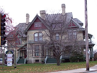
The Hearthstone Historic House Museum is a historic home in Appleton, Wisconsin, United States that has been converted into a museum. On September 30, 1882, it became the first residence in the US powered by a centrally located hydroelectric station using the Edison system. At that time, the house was the residence of Henry James Rogers, a paper company executive and entrepreneur. It was listed on the National Register of Historic Places on December 2, 1974. The house was previously known as the Henry J. Rogers House.

August A. Knuppel was a German American immigrant, mason, and contractor. He was the 32nd mayor of Appleton, Wisconsin, and was important in the development of the city.
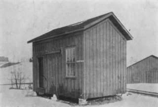
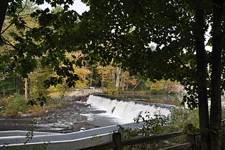
The Vulcan Street Plant was the first Edison hydroelectric central station. The plant was built on the Fox River in Appleton, Wisconsin, and put into operation on September 30, 1882. According to the American Society of Mechanical Engineers, the Vulcan Street plant is considered to be "the first hydro-electric central station to serve a system of private and commercial customers in North America". It is a National Historic Mechanical Engineering Landmark, an IEEE milestone and a National Historic Civil Engineering Landmark.

This is a list of the National Register of Historic Places listings in Outagamie County, Wisconsin. It is intended to provide a comprehensive listing of entries in the National Register of Historic Places that are located in Outagamie County, Wisconsin. The locations of National Register properties for which the latitude and longitude coordinates are included below may be seen in a map.

This is a list of the National Register of Historic Places listings in Marathon County, Wisconsin. It is intended to provide a comprehensive listing of entries in the National Register of Historic Places that are located in Marathon County, Wisconsin. The locations of National Register properties for which the latitude and longitude coordinates are included below may be seen in a map.

Washington Avenue Historic District is the historic center of Cedarburg, Wisconsin, the location of the early industry and commerce that was key to the community's development. The historic district was listed on the National Register of Historic Places (NRHP) in 1986.
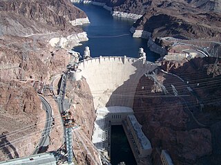
Hydroelectricity is, as of 2019, the second-largest renewable source of energy in both generation and nominal capacity in the United States. In 2021, hydroelectric power produced 31.5% of the total renewable electricity, and 6.3% of the total U.S. electricity.

Neillsville Downtown Historic District is a section of the historic old downtown of Neillsville, Wisconsin, with buildings as old as 1872. It was added to the National Register of Historic Places in 2000.
The Courthouse Hill Historic District is a 30-block area on the east side of Janesville, Wisconsin, containing many historic structures built from the mid-1800s to the early 1900s in various styles, including homes of many of Janesville's influential leaders from that period. The district was added to the National Register of Historic Places in 1986.
The Wiswall Falls Mill Site is a historic archaeological industrial site in Durham, New Hampshire. It is located in John Hatch Park, a small public park just south of Wiswall Road on the eastern bank of the Lamprey River. The 3-acre (1.2 ha) site encompasses the remains of a small 19th-century mill complex that was one of Durham's major industrial sites of the 19th century until it burned in 1883. The site, which includes remains of the waterworks and foundations, was listed on the National Register of Historic Places in 1988.

Reads Landing School is a former school building in the unincorporated community of Reads Landing, Minnesota, United States. Built in 1870, it has been converted into the Wabasha County Historical Society Museum. The building is one of the state's oldest surviving brick schools, and typifies their characteristic boxy, bracketed, Italianate style. The school was listed on the National Register of Historic Places in 1989 for having local significance in the themes of architecture and exploration/settlement. It was nominated for being a rare surviving example of Minnesota's early brick schools, and for its association with Reads Landing's peak as a lumber milling boomtown.

The Main Street Historic District is a cluster of historic buildings around the intersection of Main Street and Appleton Avenue in Menomonee Falls, Wisconsin. It was added to the National Register of Historic Places in 1988.
St. Anthony Falls in Minneapolis, Minnesota, is the only natural falls on the Mississippi River. Since almost the beginning of settlement in the area by European descendants, the St. Anthony Falls have been used for waterpower. The first allowed settlers were at Ft. Snelling, where construction began in 1820. A sawmill was operating 1821 and a flour mill in 1823. As soon as the land at the sides of the falls became available it was purchased with the intent of using the waterpower of the falls. First lumber mills covered the falls, cutting lumber floated down the Mississippi. After 1870 flour mills started to dominate the area. From 1880 to 1930 the area was the number one flour producer in the US. In later years, some of the power came from steam, but in 1923 half of the waterpower used was for flour milling. Other industries have also used the waterpower.

The Columbia Historic District is a neighborhood in Cedarburg, Wisconsin, that is listed on the National Register of Historic Places. At the time the district was listed on the register, its contributing properties included 128 historic homes, one church, and eighty-seven historic outbuildings, including garages and barns, all constructed between 1844 and 1938. The district also contained several dozen buildings that do not contribute to the historic district, including modern homes from the post-war era as well as modern garages and other additions to historic properties.


