Belvoir Castle is a stately home in the English county of Leicestershire, overlooking the Vale of Belvoir. It is a Grade I listed building. A corner of the castle is still used as the family home of the Manners family and remains the seat of the Dukes of Rutland, most of whom are buried in the grounds of the mausoleum there. The castle remains privately owned, but is open to visitors.
A hundred is an administrative division that is geographically part of a larger region. It was formerly used in England, Wales, some parts of the United States, Denmark, Southern Schleswig, Sweden, Finland, Estonia, and Norway. It is still used in other places, including South Australia and the Northern Territory.
Sparkenhoe was a hundred of Leicestershire, England in the south-west of the county, covering Market Bosworth and Hinckley, broadly corresponding to the modern districts of Blaby and Hinckley and Bosworth. The meeting place of the Sparkenhoe Hundred was probably at Shericles Farm near Desford (SK467026), which derives from scirac meaning "the hundred oak". Sparkenhoe hundred was not recorded in the Domesday Book as a wapentake, being formed in 1346 from part of Guthlaxton and Goscote.
Guthlaxton is an ancient hundred of Leicestershire. Its jurisdiction was in the south of the county, and covered Lutterworth and Wigston Magna. At the time of the Domesday Book, it was one of Leicestershire's four wapentakes, and covered a much larger area, including Market Bosworth and Hinckley, which would later be made part of the Sparkenhoe hundred.
Goscote was a wapentake in the county of Leicestershire, England; consisting of the north and north-west of the county. It was recorded in the Domesday Book, but as the wapentakes evolved to form hundreds, was split into East Goscote Hundred and West Goscote Hundred in 1346.
The origins of Derbyshire
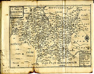
The history of Leicestershire:

Seagrave is a village and civil parish in the Charnwood district of Leicestershire, England. It has a population of around 500, measured at the 2011 census as 546, It is north of Sileby and close to Thrussington and Barrow upon Soar.

East Goscote is a modern village and civil parish in the Borough of Charnwood district of Leicestershire, England, just north of the market town of Syston. It is a medium-sized village, with a population measured at 2,866 in the 2011 census. The village is twinned with Fleury-sur-Andelle, France.
East Goscote Hundred was a hundred of Leicestershire, that arose from the division of the ancient Goscote hundred into two. It covered the eastern part of today's Charnwood district, along with the northern part of Harborough District, and extended south-east to meet Rutland.

Stockerston is a village and civil parish in the Harborough district of Leicestershire, England, located on the border with Rutland, by the Eye Brook. According to the 2001 census the parish had a population of 35. The population remained less than 100 at the 2011 census and is included in the civil parish of Horninghold.

Agbrigg and Morley was a wapentake of the West Riding of Yorkshire, England. The main purpose of the wapentake was the administration of justice by a local court. At the time of the Domesday survey in 1086, Agbrigg and Morley were separate wapentakes. For example, Methley was in Agbrigg while Rothwell was in Morley. The wapentakes were probably combined by the 13th century when similar administrative reforms occurred elsewhere in England. It was kept in two divisions, which in the mid-nineteenth century again became wapentakes in their own right.
Claro was a wapentake of the West Riding of Yorkshire, England. It was split into two divisions. The Upper Division included the parishes of Farnham, Fewston, Hampsthwaite, Kirkby Malzeard and Pannal and parts of Aldborough, Knaresborough, Otley, Little Ouseburn, Ripley, Ripon, Wetherby and Whixley, many of which formed exclaves. The Lower Division included the parishes of Allerton Mauleverer, Goldsborough, Hunsingore, Kirk Deighton, Kirkby Overblow, Leathley, Spofforth with Stockeld, Weston and parts of Addingham, Aldborough, Harewood, Ilkley, Kirk Hammerton, Otley, Ripley and Whixley.
Edenham is a village and civil parish in the South Kesteven district of Lincolnshire, England. It is approximately 3 miles (5 km) north-west of Bourne, and on the A151 road. While the civil parish is called "Edenham", the parish council is called Edenham, Grimsthorpe, Elsthorpe & Scottlethorpe Parish Council. The population of the civil parish at the 2011 census was 291. The parish is principally located in the valley of the East Glen which flows through the village.

Chadwell is a small village approximately 4 miles (6.4 km) northwest of Melton Mowbray in Leicestershire.

Muston is an English village in north-east Leicestershire, 18.6 miles east of Nottingham and five miles west of Grantham on the A52. It is 12.5 miles north of Melton Mowbray. The population of the civil parish at the 2011 census was 339. It lies on the Leicestershire/Lincolnshire county border, two miles east of Bottesford, of which it forms part of the civil parish. The River Devon flows through the village.

Eastwell is a village and ecclesiastical parish in Leicestershire, England.
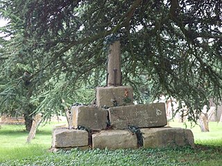
Bolt Wood is near to the western boundary of the Parish of Stockerston, Leicestershire, England. It is suggested that the woodland on this boundary is part of that mentioned in the Domesday Book. Bolt Wood was part of the extensive Royal medieval Leighfield Forest. The first written reference to Bolt Wood is in an undated charter probably dating before the reign of Henry VI, in which it is referred to as 'Boutewood'. An alternative date offered is between 1422 and 1461.