
Franklin is a town located in Franklin County, New York, United States. As of the 2010 census, the town had a population of 1,140.

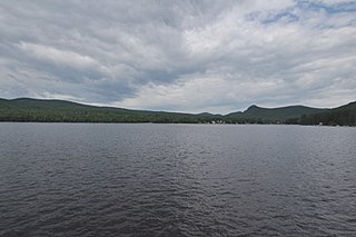
Keuka Lake State Park is a 621-acre (2.51 km2) state park located in Yates County, New York. The park is located on the north end of the west branch of Keuka Lake, one of the Finger Lakes. The park is in the southeast part of the town of Jerusalem, southeast of Branchport.

F.D. Roosevelt State Park is a 9,049 acres (36.62 km2) Georgia state park located near Pine Mountain and Warm Springs. The park is named for former U.S. President Franklin Delano Roosevelt, who sought a treatment for his paralytic illness in nearby Warm Springs at the Little White House. The park is located along the Pine Mountain Range. The western portion of the park, formerly named Pine Mountain State Park, was named a National Historic Landmark in 1997. F.D. Roosevelt State Park is Georgia's largest state park.

Meramec State Park is a public recreation area located near Sullivan, Missouri, about 60 miles from St. Louis, along the Meramec River. The park has diverse ecosystems such as hardwood forests and glades. There are over 40 caves located throughout the park, the bedrock is dolomite. The most famous is Fisher Cave, located near the campgrounds. The park borders the Meramec Conservation Area.

Interstate Park comprises two adjacent state parks on the Minnesota–Wisconsin border, both named Interstate State Park. They straddle the Dalles of the St. Croix River, a deep basalt gorge with glacial potholes and other rock formations. The Wisconsin park is 1,330 acres (538 ha) and the Minnesota park is 298 acres (121 ha). The towns of Taylors Falls, Minnesota and St. Croix Falls, Wisconsin are adjacent to the park. Interstate Park is within the Saint Croix National Scenic Riverway and the Ice Age National Scientific Reserve. The western terminus of the Ice Age National Scenic Trail is on the Wisconsin side. On the Minnesota side, two areas contain National Park Service rustic style buildings and structures that are listed on the National Register of Historic Places.

Mineral King is a subalpine glacial valley located in the southern part of Sequoia National Park, in the U.S. state of California. The valley lies at the headwaters of the East Fork of the Kaweah River, which rises at the eastern part of the valley and flows northwest. Accessed by a long and narrow winding road, the valley is mostly popular with backpackers and hikers.
Thompson's Lake State Park is a 308-acre (1.25 km2) state park located near East Berne in Albany County, New York.

Fort Cooper State Park is a 710-acre historic site in Inverness, Florida, United States. It is located two miles (3 km) south of Inverness, off of U.S. Hwy. 41 on South Old Floral City Road. On June 13, 1972, it was added to the United States National Register of Historic Places. It is also a Florida State Park.
Calumet County, Wisconsin maintains three county parks Calumet County Park, Becker's Lake Park and Ledge View Nature Center and Brothertown and Stockbridge harbors. The Stockbridge harbor is on the List of Registered Historic Places in Wisconsin. Calumet County Park is under the Calumet County Park Group, an archeological site listed on the National Register of Historic Places. Ledge View Nature Center has a nature center which explains the geology of the area.
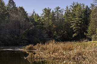
Little Beaver State Park is state park in Raleigh County, West Virginia. It is located near Beckley, West Virginia, about 2 miles (3.2 km) south of I-64 at Grandview Road, exit 129A. The park sits on the shores of 18-acre (0.07 km²) Little Beaver Lake.

Douthat State Park is a state park located in the Allegheny Mountains in Virginia. It is in Bath County and Alleghany County. The park is 4,545 acres (18 km2) total with a 50-acre (20 ha) lake, the second-largest Virginia state park after Pocahontas State Park. It is one of the original Virginia state parks built in the 1930s by the Civilian Conservation Corps.

Elmore State Park is a state park located in Elmore, Vermont, United States. It includes Lake Elmore and Elmore Mountain, and has day-use facilities for picnicking, hiking, and water-based activities, and a 59-site campground. Some of its facilities were developed in the 1930s by the Civilian Conservation Corps; for these, it was listed on the National Register of Historic Places in 2002. The park is open seasonally between Memorial Day and Columbus Day; fees are charged for day use and camping.
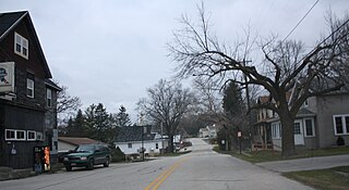
Franklin is an unincorporated community in the town of Herman, in Sheboygan County, Wisconsin, United States. Franklin is located at the intersection of County Highway M and the Sheboygan River, about 1 mile (1 km) from Lakeland College. The Franklin Feed Mill is listed on the National Register of Historic Places. The town hall for Herman is located inside the community.

This is a list of the National Register of Historic Places listings in Vilas County, Wisconsin. It is intended to provide a comprehensive listing of entries in the National Register of Historic Places that are located in Vilas County, Wisconsin. The locations of National Register properties for which the latitude and longitude coordinates are included below may be seen in a map.

This is a list of the National Register of Historic Places listings in Forest County, Wisconsin. It is intended to provide a comprehensive listing of entries in the National Register of Historic Places that are located in Forest County, Wisconsin. The locations of National Register properties for which the latitude and longitude coordinates are included below may be seen in a map.

The Anvil Lake Campground Shelter is located in Eagle River, Wisconsin. It was built by the Civilian Conservation Corps of the New Deal and was added to the National Register of Historic Places in 1996.

Lake George Battlefield Park Historic District is a national historic district relating to the French and Indian War Battle of Lake George and located near Lake George in Warren County, New York. The parkland was purchased and developed by New York State between 1896 and 1965. It encompasses numerous significant archaeological sites related to a series of conflicts dated from about 1755 to 1814. The archaeological sites include those related to Fort George (1759), earthen trenches (1757-1758), and barracks and hospitals dated to the 1750s. The historic districts also includes a number of plaques and monuments including those commemorating Henry Knox (1925), the Bloody Morning Scout (1935), Fr. Isaac Jogues (1939), King Hendrick Theyanoguin and General William Johnson. Other contributing features relate to the property's development as a park and include the battlefield park and battlefield campground, Fort George Road, the Delaware and Hudson Railway right of way, the Dowling Farmhouse, and the maintenance complex.

The Camp Ouachita Girl Scout Camp Historic District encompasses a campground area built by crews of the Civilian Conservation Corps in the 1930s on the northern shore of Lake Sylvia, a man-made lake in the eastern part of Ouachita National Forest. The center of the campground, including its Great Hall and administration buildings, is located at the northern tip of Lake Sylvia, with cabins, comfort facilities, and other infrastructure arrayed around the northern and western sides of the lake. It was the first Girl Scout camp in the state, and is a well-preserved example of the Rustic style of architecture for which the CCC is known.
Stillwater State Park is a state park located on Lake Groton in Groton, Vermont. The park is located in Groton State Forest close to the Groton Nature Center, Boulder Beach State Park and Big Deer State Park. The park offers camping, picnicking, and access to water-related activities on Lake Groton. The park was developed in the 1930s by crews of the Civilian Conservation Corps (CCC). It is open to the public between Memorial Day weekend and Columbus Day weekend; fees are charged for day use and camping.

New Discovery State Park is a state park near Marshfield, Vermont in the United States. It is one of seven state parks located in Groton State Forest. The park is on Vermont Route 232, offering camping, picnicking, and access to forest trails. The park was developed in the 1930s by the Civilian Conservation Corps; its major CCC-built facilities, located mainly in western Peacham, were listed on the National Register of Historic Places in 2002.
