Related Research Articles
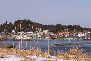
Seldovia is a city in Kenai Peninsula Borough, Alaska, United States. Its population was 255 at the 2010 census, down from 286 in 2000. It is located along Kachemak Bay southwest of Homer. There is no road system connecting the town to other communities, so all travel to Seldovia is by airplane or boat.

Mendeltna is a census-designated place (CDP) in Valdez-Cordova Census Area, Alaska, United States. The population was 39 at the 2010 census, down from 63 in 2000.

Arctic Village is an unincorporated Native American village and a census-designated place (CDP) in Yukon-Koyukuk Census Area, Alaska, United States. As of the 2010 census, the population of the CDP was 152. This was unchanged from 2000. The village is located in the large Gwitch'in speaking region of Alaska, and the local dialect is known as Di'haii Gwitch'in or Kutchin. As of 1999, over 95% of the community speaks and understands the language.

Fort Yukon is a city in the Yukon-Koyukuk Census Area in the U.S. state of Alaska, straddling the Arctic Circle. The population, predominantly Gwich'in Alaska Natives, was 583 at the 2010 census, down from 595 in 2000.

Beckett Ridge is a census-designated place (CDP) in West Chester Township, Butler County, Ohio, United States. The population was 9,187 at the 2010 census.

The Alaska North Slope is the region of the U.S. state of Alaska located on the northern slope of the Brooks Range along the coast of two marginal seas of the Arctic Ocean, the Chukchi Sea being on the western side of Point Barrow, and the Beaufort Sea on the eastern.

Franklin Mine is a small unincorporated community in Houghton County, Michigan, United States. The area is on Quincy Hill, northeast of Hancock, and lying partially within Quincy Township and partially within Franklin Township.

The Canada–United States border is the longest international border in the world between two countries. The terrestrial boundary is 8,891 kilometers (5,525 mi) long. The land border has two sections: Canada's border with the contiguous United States to its south, and with the U.S. state of Alaska to its west. The bi-national International Boundary Commission deals with matters relating to marking and maintaining the boundary, and the International Joint Commission deals with issues concerning boundary waters. The agencies currently responsible for facilitating legal passage through the international boundary are the Canada Border Services Agency (CBSA) and U.S. Customs and Border Protection (CBP).
The Granite Mountains is a small mountain range in the Southeast Fairbanks Census Area of the U.S. state of Alaska.

The Seward Peninsula is a large peninsula on the western coast of the U.S. state of Alaska whose westernmost point is Cape Prince of Wales. The peninsula projects about 320 kilometers (200 mi) into the Bering Sea between Norton Sound, the Bering Strait, the Chukchi Sea, and Kotzebue Sound, just below the Arctic Circle. The entire peninsula is about 330 kilometers (210 mi) long and 145 km (90 mi)-225 km (140 mi) wide. Like Seward, Alaska, it was named after William H. Seward, the United States Secretary of State who fought for the U.S. purchase of Alaska.

Orca Inlet is an arm of Prince William Sound in southern Alaska. The town of Cordova was founded on its coast in 1906. All marine traffic reaches the town through Orca Inlet.
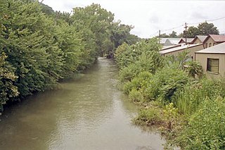
New Creek is an 18.4-mile-long (29.6 km) stream in eastern West Virginia, United States. It is the third major West Virginia tributary to the North Branch Potomac River. Via the Potomac, it is part of the watershed of Chesapeake Bay.

The Escalante Desert is a geographic Great Basin region and arid desert ecoregion, in the deserts and xeric shrublands biome, located in southwestern Utah.

Buena Vista is an unincorporated community in Posey Township, Franklin County, Indiana.
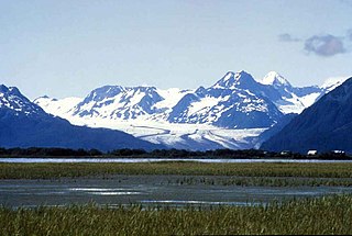
Scott Glacier is a 15-mile-long (24 km) glacier located in the Chugach Mountains, near Cordova, Alaska. It begins at 60°44′31″N145°04′20″W and trends southwest to 60°37′11″N145°23′09″W, 13 miles (21 km) east northeast of Cordova. The Scott Glacier was named in 1908 after a "local miner".

The Yukon Flats are a vast area of wetlands, forest, bog, and low-lying ground centered on the confluence of the Yukon River, Porcupine River, and Chandalar River in the central portion of the U.S. state of Alaska. The Yukon Flats are bordered in the north by the Brooks Range, in the south by the White Mountains, and cover an area of approximately 11,000 square miles (28,490 km2). The Yukon Flats are a critical waterfowl breeding ground due to the large area of wetland provided by the estimated 40,000 small lakes and streams in the area. In recognition of this fact, the area is protected under the Yukon Flats National Wildlife Refuge.
Rika's Landing Roadhouse, also known as Rika's Landing Site or the McCarty Roadhouse, is a roadhouse located at a historically important crossing of the Tanana River, in the Southeast Fairbanks Area, Alaska, United States. It is off mile 274.5 of the Richardson Highway in Big Delta.

Agalina Glacier is a 4.8 km (3.0 mi) long and 2.9 km (1.8 mi) wide glacier on Pefaur (Ventimiglia) Peninsula, Danco Coast on the west side of Antarctic Peninsula, situated east of Poduene Glacier and west of Krapets Glacier. It drains northwards, and flows into both Graham Passage and the west arm of Salvesen Cove.

The Klawasi group is a cluster of three large mud volcanoes on the western flank of Mount Drum, a Pleistocene stratovolcano in the Wrangell Mountains of east-central Alaska in the United States. The cluster includes the Upper Klawasi, the Lower Klawasi and the Shrub.
Valeene is an unincorporated community in Southeast Township, Orange County, in the U.S. state of Indiana.
References
Coordinates: 69°08′24″N145°26′20″W / 69.14000°N 145.43889°W
| | This article about a location in the North Slope Borough, Alaska is a stub. You can help Wikipedia by expanding it. |