
Geretsried is a town in the district Bad Tölz-Wolfratshausen, located in Bavaria, Germany. The town is the most populated town in the district, with 23,219 inhabitants as of 31 December 2012.

Oberschleißheim is a municipality in the district of Munich, and a suburb to Munich in Bavaria, in southern Germany. It is located 13 km north of Munich (centre). As of 2005 it had a population of 11,467.
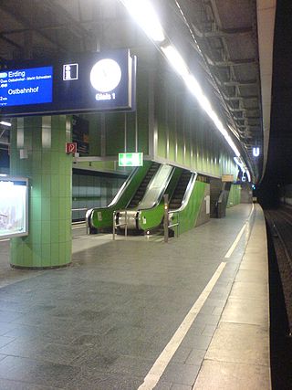
Munich Isartor station is a station opened in 1972 on the Munich S-Bahn on the trunk line between Munich Central Station and Munich East station (Ostbahnhof). It is located below Isartorplatz and the Thierschstraße/Zweibrückenstraße intersection in Munich and is named after the nearby Isartor city gate. It is classified by Deutsche Bahn as a category 4 station.

Thalkirchen-Obersendling-Forstenried-Fürstenried-Solln is the 19th borough of Munich, Germany, comprising the extreme southern part of the city on the west bank of the river Isar. After the administrative reform, the boroughs Thalkirchen-Obersendling-Forstenried and Solln were incorporated, thus forming the new borough. It comprises 17.7631 square kilometres and has a population of 96,714 residents.

Großhesselohe Isartalbahn station is a station on the Isar Valley Railway from Munich to Bichl in the German state of Bavaria. Since 1981, it has been a station of the Munich S-Bahn. The station is located in the municipality of Pullach, which also contains the stations of Pullach and Höllriegelskreuth. It is classified by Deutsche Bahn as a category 5 station and has two platform tracks. The station building is registered as a historic building on the List of Bavarian Monuments.

Maillingerstraße is a street in the Munich districts of Maxvorstadt and Neuhausen. Running from north to south, it connects Nymphenburger Straße with Marsstraße. It is named after the Bavarian general and Minister of War Joseph Maximilian von Maillinger. The street has been named Maillingerstraße since 1886. Today Maillingerstraße is a traffic calmed secondary road.

Ludwigsvorstadt-Isarvorstadt is one of the boroughs of Munich, Germany.
The Munich–Holzkirchen railway is a continuously-electrified, double-track, railway in the German state of Bavaria. It runs from Munich to Holzkirchen via Deisenhofen.

Line S20 is a line on the Munich S-Bahn network. It is operated by DB Regio Bayern. It runs from München-Pasing station to Höllriegelskreuth. It runs on a connecting line from Pasing to München Mittersendling station that has a platform at München Heimeranplatz station, but does not have a platform at München Harras, although the track here lies directly next to the Munich–Holzkirchen line. It is operated during peak hours from Monday through Friday. It is operated using class 423 four-car electrical multiple units.

Ebenhausen-Schäftlarn station is a station on the Isar Valley Railway from Munich to Bichl in the German state of Bavaria. Since 1981, it has been a station of the Munich S-Bahn. The station building is registered as a historic building on the List of Bavarian Monuments.
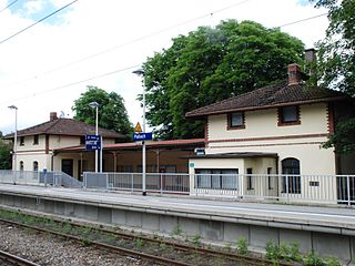
Pullach station is a station on the Isar Valley Railway from Munich to Bichl in the German state of Bavaria. It has been part of the Munich S-Bahn since 1981. The station is located in the municipality of Pullach, which also contains the stations of Großhesselohe Isartal and Höllriegelskreuth. It is classified by Deutsche Bahn as a category 6 station and has two platforms. The station building is registered as a historic building on the List of Bavarian Monuments and has been acquired by the municipality of Pullach. It currently operates the station and is considering how the station building and the surrounding area could be used in future development, including aesthetic improvements.

The Königinstraße is a street in Munich. It runs west of the Englischer Garten from the Von-der-Tann-Straße in the district of Maxvorstadt, to the north and to the Maria-Josepha-Straße and Mandlstraße in the Ensemble Alt-Schwabing.

Angertorstraße 3 is an apartment building in Munich, Germany that is a registered Bavarian historical monument.

The Türkenstraße is an inner city street in Munich's district Maxvorstadt. It is named after the Türkengraben to which it ran. In the list of historical monuments in Munich, more than 30 objects are listed in the Türkenstraße.
Stollbergstraße 20, is a building located in the old town of Munich, Germany. The main and auxiliary buildings are part of the historical building ensemble of the old town.

The Lindwurmstraße is a 2.4-kilometer poplar alley in the Munich districts Ludwigsvorstadt-Isarvorstadt and Sendling.

Wolfratshauser Straße is a major road in Munich. It forms part of the Bundesstraße 11 and is named after the city Wolfratshausen south of Munich, in whose direction it leads.

The Munich Old Town is part of the Bavarian capital Munich and has belonged to the city the longest, even if some places which are meanwhile districts of Munich, were mentioned long before Munich's documents spoke of the Old Town. The Old Town forms together with the district Lehel, the municipality No. 1 Altstadt-Lehel. The entire area of the Old Town is listed as both a historical ensemble as well as a historical monument listed in the Bavarian historical monument list.
Boschetsrieder Straße is an inner city street in the Munich districts of Thalkirchen, Obersendling and Forstenried/Am Waldfriedhof, which runs west from Bundesstraße 11 on the Isar hillside to Kreuzhof, where it continues as the Fürstenrieder Straße.

Kurfürstenplatz is a square in the Munich district of Schwabing and is located about two and a half kilometres north of the city centre. It is the intersection of several streets and tram lines and was built in 1915 and named after the Elector Maximilian II. Emanuel, born in Munich in 1662.

