Gallery
 Freeman strait
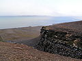 Freeman strait
Freeman Strait (Norwegian: Freemansundet) is the sound separating Barents Island, to the north, from Edge Island, in the Svalbard archipelago, Norway.
The strait is named after Alderman Ralph Freeman, who was involved in the English whaling trade in the early 17th century. [1] The polar bear, Ursus maritimus, is a seasonal visitor to the Freemansundet; this species has a genetically distinct deme within the Barents Sea region. [2] It was later known to the Dutch as Walter Thymens' Sound. [3]


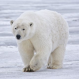
The polar bear is a hypercarnivorous species of bear. Its native range lies largely within the Arctic Circle, encompassing the Arctic Ocean and its surrounding seas and landmasses, which includes the northernmost regions of North America and Eurasia. It is the largest extant bear species, as well as the largest extant land carnivore. A boar weighs around 350–700 kg (770–1,540 lb), while a sow is about half that size. Although it is the sister species of the brown bear, it has evolved to occupy a narrower ecological niche, with many body characteristics adapted for cold temperatures, for moving across snow, ice and open water, and for hunting seals, which make up most of its diet. Although most polar bears are born on land, they spend most of their time on the sea ice. Their scientific name means "maritime bear" and derives from this fact. Polar bears hunt their preferred food of seals from the edge of sea ice, often living off fat reserves when no sea ice is present. Because of their dependence on the sea ice, polar bears are classified as marine mammals.

The Barents Sea is a marginal sea of the Arctic Ocean, located off the northern coasts of Norway and Russia and divided between Norwegian and Russian territorial waters. It was known among Russians in the Middle Ages as the Murman Sea ; the current name of the sea is after the historical Dutch navigator Willem Barentsz.

Victoria Island is a large island in the Arctic Archipelago that straddles the boundary between Nunavut and the Northwest Territories of Canada. It is the eighth-largest island in the world, and at 217,291 km2 (83,897 sq mi) in area, it is Canada's second-largest island. It is nearly double the size of Newfoundland (111,390 km2 [43,010 sq mi]), and is slightly larger than the island of Great Britain (209,331 km2 [80,823 sq mi]) but smaller than Honshu (225,800 km2 [87,200 sq mi]). The western third of the island lies in the Inuvik Region of the Northwest Territories; the remainder is part of Nunavut's Kitikmeot Region. The population of 2,168 is divided among 2 settlements, the larger of which is in Nunavut and the other of which is in the Northwest Territories.

Bear Island is the southernmost island of the Norwegian Svalbard archipelago. The island is located in the western part of the Barents Sea, approximately halfway between Spitsbergen and the North Cape. Bear Island was discovered by Dutch explorers Willem Barentsz and Jacob van Heemskerck on 10 June 1596. It was named after a polar bear that was seen swimming nearby. The island was considered terra nullius until the Spitsbergen Treaty of 1920 placed it under Norwegian sovereignty.

Ursinae is a subfamily of Ursidae (bears) named by Swainson (1835). It was assigned to Ursidae by Bjork (1970), Hunt (1998) and Jin et al. (2007).

Kotzebue Sound is an arm of the Chukchi Sea in the western region of the U.S. state of Alaska. It is on the north side of the Seward Peninsula and bounded on the east by the Baldwin Peninsula. It is 100 miles (160 km) long and 70 miles (110 km) wide.

Edgeøya, anglicised as Edge Island, is a Norwegian island located in southeast of the Svalbard archipelago; with an area of 5,073 square kilometres (1,960 sq mi), it is the third-largest island in this archipelago. An Arctic island, it forms part of the Søraust-Svalbard Nature Reserve, home to polar bears and reindeer. An ice field covers its eastern side. The island takes its name from Thomas Edge, an English merchant and whaler. It is seldom visited today and development of tourist facilities is forbidden by law because of its nature reserve status.
Hopen is an island in the southeastern part of the Svalbard archipelago (Norway). Hopen was discovered in 1596 by Jan Cornelisz Rijp during the third expedition by Willem Barentsz, trying to find the Northeast Passage. Later, in 1613, its name was given by Thomas Marmaduke of Hull, who named it after his former command, the Hopewell.
Miseryfjellet, at 536 metres (1,759 ft), is the tallest peak on Bear Island (Bjørnøya), a Norwegian island in the Barents Sea. Miseryfjellet is on the eastern side of Bear Island and contains three distinct component peaks, Urd, Verdande and Skuld. These peaks are named after the three Norns in Norse Mythology. The name Bear Island is derived from the seasonal presence of polar bears, Ursus maritimus, whose population in the Barents Sea region is a genetically distinct sub-population of this species.

Barentsøya, anglicized as Barents Island, is an island in the Svalbard archipelago of Norway, lying between Edgeøya and Spitsbergen. Barents Island has no permanent human inhabitants. Named for the Dutch explorer Willem Barents, it is a part of Søraust-Svalbard Nature Reserve.

An ursid hybrid is an animal with parents from two different species or subspecies of the bear family (Ursidae). Species and subspecies of bear known to have produced offspring with another bear species or subspecies include black bears, grizzly bears and polar bears, all of which are members of the genus Ursus. Bears not included in Ursus, such as the giant panda, are expected to be unable to produce hybrids with other bears. The giant panda bear belongs to the genus Ailuropoda.
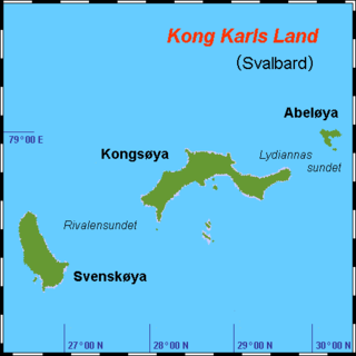
Kong Karls Land or King Charles Land is an island group in the Svalbard archipelago, in the Arctic Ocean. The island group covers an area of 342 km2 (132 sq mi) and is made up of the islands of Kongsøya, Svenskøya, Abel Island, Helgoland Island, and Tirpitzøya.

Pechora Sea, is a sea at the northwest of Russia, the southeastern part of the Barents Sea. The western border of the sea is off Kolguyev Island, while the eastern border is the western coasts of Vaygach Island and the Yugorsky Peninsula, and the northern border the southern end of Novaya Zemlya.

Alexandra Land is a large island located in Franz Josef Land, Arkhangelsk Oblast, Russian Federation. Not counting detached and far-lying Victoria Island, it is the westernmost island of the Franz Josef Archipelago. It is the site of a Russian military base that was reopened in 2017.

The Hinlopen Strait is the strait between Spitsbergen and Nordaustlandet in Svalbard, Norway. It is 150 kilometers (93 mi) long and 10 to 60 kilometers wide. The strait is difficult to pass because of pack ice. It is believed to have been named after Thijmen Jacobsz Hinlopen. The strait was previously known to the Englishmen as Smith Channel, but it was the Dutch who proved it to be a strait.

Amsterdam Island is a small island off the northwest coast of West-Spitsbergen. It is separated from Danes Island by the strait Danskegattet. Its total area is 16.8 km2. Its highest point is Hiertabreen, at 472 meters above sea level. The percentage of the island covered in ice is 11.5%.
A maternity den, in the animal kingdom, is a lair where the mother gives birth and nurtures the young, when they are in a vulnerable life stage. While such dens are typically subterranean, they may also be snow caves or simply beneath rock ledges. Characteristically there is an entrance, and optionally an exit corridor, in addition to a principal chamber.

Ursus maritimus tyrannus is a controversial extinct subspecies of polar bear.
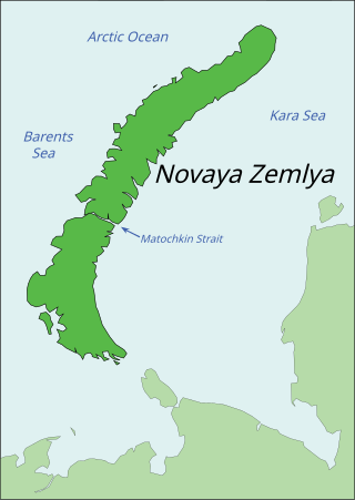
Novaya Zemlya is an archipelago in northern Russia. It is situated in the Arctic Ocean, in the extreme northeast of Europe, with Cape Flissingsky, on the northern island, considered the easternmost point of Europe. To Novaya Zemlya's west lies the Barents Sea and to the east is the Kara Sea.
Coordinates: 78°13′N21°19′E / 78.217°N 21.317°E
| | This Svalbard location article is a stub. You can help Wikipedia by expanding it. |