Armstrong County is a county in the Commonwealth of Pennsylvania. As of the 2020 census, the population was 65,558. The county seat is Kittanning. The county was organized on March 12, 1800, from parts of Allegheny, Westmoreland and Lycoming Counties. It was named in honor of John Armstrong, who represented Pennsylvania in the Continental Congress and served as a major general during the Revolutionary War.

Butler County is a county in the Commonwealth of Pennsylvania. As of the 2020 census, the population was 193,763. Its county seat is Butler. Butler County was created on March 12, 1800, from part of Allegheny County and named in honor of General Richard Butler, a hero of the American Revolution. The county is part of the Greater Pittsburgh region of the state.

Freeport is a borough in Armstrong County, Pennsylvania, United States. It is situated along the Allegheny River in the southwestern corner of the county. The population was 1,736 at the 2020 census.

South Buffalo Township is a township in Armstrong County, Pennsylvania, United States. The population was 2,713 at the 2020 census, an increase from the figure of 2,636 tabulated in 2010.

Worthington is a borough in Armstrong County, Pennsylvania, United States. The population was 594 at the 2020 census.

Buffalo Township is a township in Butler County, Pennsylvania, United States. The population was 7,896 at the 2020 census.

Butler is a city and the county seat of Butler County, Pennsylvania, United States. It is 35 miles (56 km) north of Pittsburgh and part of the Greater Pittsburgh region. As of the 2020 census, the population was 13,502.

Harrison Township is a township in Allegheny County in the U.S. state of Pennsylvania. The population was 10,169 at the 2020 census. Pennsylvania Route 28 passes through Harrison Township, connecting Kittanning to the northeast and Pittsburgh to the southwest. Allegheny Technologies has extensive steel mill facilities in Harrison Township, including its Allegheny Ludlum Brackenridge Works. Harrison Township is located at the far northeast corner of Allegheny County. Its northern border is the Butler County line and the Allegheny River forms the township's eastern boundary with Westmoreland County. Its northeast corner also touches Armstrong County.

The Central Bucks School District (CBSD) is a school district located in Pennsylvania and the third-largest school district in the state. The district covers the Boroughs of Chalfont, Doylestown and New Britain and Buckingham Township, Doylestown Township, Plumstead Township, Warrington Township, Warwick Township, and most of New Britain Township, in Bucks County. More than 3,000 staff serve more than 17,000 students in fifteen elementary schools, five middle schools, and three high schools. There is a 99% graduation rate and over 280 extracurricular activities. Dr. Steven Yanni serves as Acting Superintendent.

The Bethel Park School District is a large, suburban school district in Allegheny County, Pennsylvania, United States. The district covers the Municipality of Bethel Park and a portion of the borough of Castle Shannon, suburbs of Pittsburgh. Bethel Park School District encompasses approximately 12 square miles (31 km2). According to 2000 federal census data, it serves a resident population of 33,556. In 2009, the residents' per capita income was $25,768, while the median family income was $64,140.

The Moon Area School District is located about 16 miles northwest of Pittsburgh, Pennsylvania. It serves a portion of the West Hills/Airport Area and comprises Crescent and Moon townships, which include unincorporated villages such as Glenwillard, Wireton, Coraopolis Heights, Thorn Hollow, West Coraopolis, Carnot, Thorn Run Valley, and Mooncrest. Moon Area School District encompasses approximately 31 square miles. The district's administration offices are located inside Moon Area High School, at 8353 University Boulevard, Moon Township, PA 15108.
Buffalo Creek is a tributary of the Allegheny River in Armstrong and Butler counties, Pennsylvania in the United States.

The Butler Area School District (BASD) is a school district in western Pennsylvania, headquartered in Butler Township, Butler County; the office has a Butler postal address. It encompasses approximately 150 square miles (390 km2) and operates ten schools.
Sarver is an unincorporated community in Buffalo Township, Butler County, Pennsylvania. It is located in the south-eastern part of the county. Sarver is generally known as most of the area near and west/southwest of State Route 356 in the township. Until around the late 1990s- early 2000s, Sarver was home to only a few residents. Its economy was very small and was based solely on a grocery store, a few small restaurants, along with a few gas stations and car dealerships. It has since grown to hold many new medium to high income housing plans, with the addition of many new shopping centers and businesses. The ZIP code is 16055. The population of the zip code is 8,486.
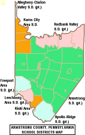
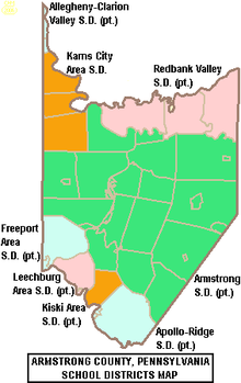
The Armstrong School District is a large, public school district which encompasses approximately 437 square miles (1,130 km2). The district is one of the 500 public school districts of Pennsylvania. In Armstrong County, Pennsylvania, Armstrong School District covers the Boroughs of Applewold, Atwood, Dayton, Elderton, Ford City, Ford Cliff, Kittanning, Manorville, Rural Valley, West Kittanning and Worthington and the Townships of Bethel Township, Boggs Township, Burrell Township, Cadogan Township, Cowanshannock Township, East Franklin Township, Kittanning Township, Manor Township, North Buffalo Township, Pine Township, Plumcreek Township, Rayburn Township, South Bend Township, Valley Township, Washington Township, Wayne Township and West Franklin Township. In Indiana County, Pennsylvania, the district includes the Borough of Smicksburg and West Mahoning Township. According to 2000 federal census data, it served a resident population of 44,970. By 2010, the District's population had declined to 43,301 people. In 2009, Armstrong School District residents' per capita income was $15,449, while the median family income was $36,907.

The 60th Pennsylvania House of Representatives District is located in western Pennsylvania has been represented by Abby Major since 2021.

Pennsylvania Route 128 is a 15.8-mile-long (25.4 km) state highway located in Armstrong County, Pennsylvania. The southern terminus is at PA 356 in Freeport. The northern terminus is at PA 66 in Ford City.

Allegheny-Clarion Valley School District (ACVSD) is a small, rural, public school district in western Pennsylvania. It spans portions of four counties and is the only Pennsylvania public school district to do so. The district is one of the 500 public school districts of Pennsylvania. The Allegheny-Clarion Valley School District encompasses approximately 121 square miles (310 km2). In Armstrong County it covers the City of Parker and Hovey Township. In Butler County it serves Allegheny Township. In Clarion County it serves the Boroughs of Emlenton, Foxburg and St. Petersburg and Perry Township and Richland Township. In Venango County it serves the Borough of Emlenton and Richland Township and Scrubgrass Township. According to 2000 federal census data, Allegheny-Clarion Valley School District serves a resident population of 5,944. By 2010, the district's population declined to 5,749 people. In 2009, the district residents' per capita income was $15,525, while the median family income was $36,867. In the Commonwealth of Pennsylvania, the median family income was $49,501 and the United States median family income was $49,445, in 2010. By 2013, the median household income in the United States rose to $52,100.
Pennsylvania Route 356 is a 32.5-mile-long (52.3 km) state highway located in Westmoreland, Allegheny, Butler, and Armstrong counties in Pennsylvania. The southern terminus is at PA 66 near Oklahoma. The northern terminus is at U.S. Route 422 (US 422) near Butler.
Karn City Area School District is a public school district in Butler County, Clarion County, and Armstrong County, Pennsylvania. The district serves the boroughs of Chicora, Fairview, Karns City, Petrolia, and Bruin, and the townships of Parker, Fairview, and Donegal in Butler County, the townships of Perry, Sugarcreek, and Bradys Bend in Armstrong County, and the borough of East Brady and Brady Township in Clarion County. There is one K–6 elementary school- Karns City Area Elementary, as well as Karns City Area Junior/Senior High School. The district encompasses approximately 125 square miles (320 km2). According to 2000 federal census data, it serves a resident population of 10,720.