Allamakee County is the northeastern-most county in the U.S. state of Iowa. As of the 2010 census, the population was 14,330. Its county seat is Waukon.

The Iowa River is a tributary of the Mississippi River in the state of Iowa in the United States. It is about 323 miles (520 km) long and is open to small river craft to Iowa City, about 65 miles (105 km) from its mouth. Its major tributary is the Cedar River.
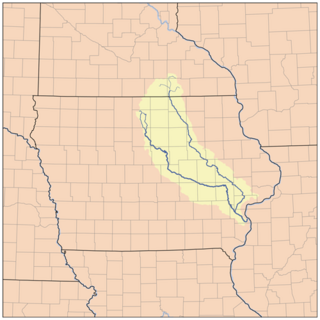
The Cedar River is a 338-mile-long (544 km) river in Minnesota and Iowa. It is a tributary of the Iowa River, which flows to the Mississippi River. The Cedar River takes its name from the red cedar trees growing there, and was originally called the Red Cedar River by the Meskwaki. The first Mississippi steamboat reached Cedar Rapids, Iowa in 1844, and during the next decade, the Red Cedar was an important commercial waterway. The surrounding region is known officially as the Cedar River Valley, though it is more commonly referred to simply as the Cedar Valley.
The Fabius River is a 3.5-mile-long (5.6 km) tributary of the Mississippi River in northeastern Missouri in the United States. It is formed near its mouth by the confluence of the North Fabius River and the South Fabius River. The North Fabius River also flows through southeastern Iowa. The Middle Fabius River joins the North Fabius 8.9 miles (14.3 km) upstream of that river's mouth.

Paint Creek is a direct tributary of the Upper Mississippi River, rising in central Allamakee County, Iowa, in and about the city of Waukon. The catchment measures approximately 85.5 square miles (221 km2). It has some still-rural stretches past 9th Street Southwest in Waukon, but most of the actual Waukon portions have been culverted. It joins the Mississippi approximately 6 miles (9.7 km) above Marquette, Iowa in Pool 10, near river mile 641.
Cold Water Spring State Preserve is a 60-acre (240,000 m2) parcel state preserve protecting a spring that issues from Cold Water Cave, an extensive cave system in Winneshiek County, Iowa and Fillmore County, Minnesota. The spring is a tributary of the Upper Iowa River.

Jacks Fork is one of two rivers in Missouri that are part of the Ozark National Scenic Riverways system.

Sny Magill Creek is a minor tributary of the Upper Mississippi River, rising in central Clayton County, Iowa and flowing to the Upper Mississippi River approximately 2 miles north of Clayton, Iowa. It has a drainage of 22,780 acres (92.2 km2). It is regarded as one of the best trout streams in Iowa. The majority of this forested basin is incorporated into the Sny Magill-North Cedar Creek Wildlife Management Area.
Clear Creek is a minor tributary of the Upper Mississippi River entirely contained within Allamakee County, Iowa. It enters the Mississippi into Navigation Pool 9 through the city of Lansing, Iowa. Iowa Highway 9 runs through its canyon. It has been restored as fishing stream for brown trout. The stream gives its name to Clear Creek Park in Lansing.

Wexford Creek is a very minor tributary of the Upper Mississippi River, confined entirely to Lafayette Township in Allamakee County, Iowa. Its drainage area measures 11.9 square miles (31 km2). It enters the river into Lake Winneshiek opposite Lynxville, Wisconsin. The area is entirely rural, with some cleared farmland, but is mostly forested.
Bear Creek, also known as Bear Hollow Creek, is a 6.3-mile-long (10.1 km) tributary of the Yellow River of Iowa, originating in Jefferson Township, near Rossville in Allamakee County. It parallels Allamakee County Road X26. It enters the Yellow River near Volney, approximately where the state of Iowa maintains the Yellow River Valley Canoe and Heritage Trail in Allamakee County.
The Trout River is a 13.5-mile-long (21.7 km) tributary of the Upper Iowa River in northeastern Iowa. It rises in Frankville Township in Winneshiek County, south of Iowa Highway 9, and flows north to join the Upper Iowa River in Glenwood Township, east of Decorah. It is joined from the west by a major tributary, Trout Creek. The river and creek should not be confused with another Trout Creek which flow into the Upper Iowa River 5 miles (8 km) to the west at Decorah.
Spook Cave is a flooded cave located about seven miles (11 km) west of McGregor in rural Clayton County, Iowa. It is privately owned and operated as a tourist attraction offering escorted boat rides into the cave. The cave was first discovered in 1953 and opened for business in 1955.
Hartley Fort State Preserve is a 2-acre (8,100 m2) Iowa state preserve located on the Upper Iowa River in the Driftless Area, in Allamakee County of Iowa, USA.
Arroyo Calabasas is a 7.0-mile-long (11.3 km) tributary of the Los Angeles River, in the southwestern San Fernando Valley area of Los Angeles County in California.
Dumas Creek is a stream in Clark County, Missouri. It is a tributary on the west side of the Des Moines River and Lee County, Iowa lies across the river.
Dumas is an unincorporated community in Clark County, in the U.S. state of Missouri. The community was located along the banks of Dumas Creek just west (upstream) of the confluence with the Des Moines River. The Atchison, Topeka and Santa Fe Railroad line was adjacent to the community site. Revere lies to the southwest of the location and Argyle, Iowa lies to the northeast along the rail line.
Fox River is a stream in Davis, Guthrie, Van Buren counties of Iowa and Clark County of Missouri. It is a tributary of the Mississippi River.
Voss Creek is a stream in Franklin County in the U.S. state of Missouri. It is a tributary of the Bourbeuse River.
Tuque Creek is a stream in southeastern Warren County in the U.S. state of Missouri. It is a tributary of Charrette Creek which it joins within the Missouri River floodplain between Marthasville and Dutzow.