
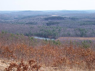
Hudson Highlands State Park is a non-contiguous state park in the U.S. state of New York, located on the east side of the Hudson River. The park runs from Peekskill in Westchester County, through Putnam County, to Beacon in Dutchess County, in the eastern section of the Hudson Highlands.

Hueston Woods State Park is a state park located in Butler and Preble counties of the U.S. state of Ohio, about five miles (8 km) northeast of Oxford in the southwestern part of the state. The park lies in Oxford Township, Butler County, and Israel Township, Preble County. It has nearly 3,000 acres (1,200 ha), including a man-made lake of 625 acres (253 ha). The park's beech-maple climax forest has been designated a National Natural Landmark.

Warriors Path State Park is a Pennsylvania state park on 349 acres (141 ha) in Liberty Township, Bedford County, Pennsylvania, in the United States. It is named for the Great Indian Warpath that was used by the Iroquois in war raids with the Cherokee and other tribes. Warriors Path State Park is surrounded on three sides by the Raystown Branch Juniata River. The park is a seasonal day use park. The park can be accessed by foot from the main gate when the gate is closed November through mid-April.

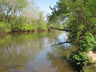
Ridley Creek State Park is a 2,606-acre (1,055 ha) Pennsylvania state park in Edgmont, Middletown, and Upper Providence Townships, Delaware County, Pennsylvania in the United States. The park, about 5 miles (8 km) north of the county seat of Media, offers many recreational activities, such as hiking, biking, fishing, and picnicking. Ridley Creek passes through the park. Highlights include a 5-mile (8 km) paved multi-use trail, a formal garden designed by the Olmsted Brothers, and Colonial Pennsylvania Plantation, which recreates daily life on a pre-Revolutionary farm. The park is adjacent to the John J. Tyler Arboretum. Ridley Creek State Park is just over 16 miles (26 km) from downtown, Philadelphia between Pennsylvania Route 352 and Pennsylvania Route 252 on Gradyville Road.
Mohawk State Forest, also known as Mohawk State Forest/Mohawk Mountain State Park, encompasses over 4,000 acres (1,600 ha) in the towns of Cornwall, Goshen, and Litchfield in the southern Berkshires of Litchfield County, Connecticut. As overseen by the Connecticut Department of Energy and Environmental Protection, the area is used for hiking, picnicking, and winter sports by the public, while being actively managed to produce timber and other forest products.

Fort Churchill State Historic Park is a state park of Nevada, United States, preserving the remains of a United States Army fort and a way station on the Pony Express and Central Overland Routes dating back to the 1860s. The site is one end of the historic Fort Churchill and Sand Springs Toll Road. The park is in Lyon County south of the town of Silver Springs, on US Route 95 Alternate, eight miles (13 km) south of US Route 50. Fort Churchill was designated a National Historic Landmark in 1961. A 1994 park addition forms a corridor along the Carson River.
French Creek State Park is a 7,977-acre (3,228 ha) Pennsylvania state park in North Coventry and Warwick Townships in Chester County and Robeson and Union Townships in Berks County, Pennsylvania. It straddles northern Chester County and southern Berks County along French Creek. It is located in the Hopewell Big Woods. The park is the home of two lakes: Hopewell Lake, a 68-acre (28 ha) warm water lake, and Scotts Run Lake, a 22-acre (8.9 ha) cold water lake. The state record smallmouth bass was caught in Scotts Run Lake. There are extensive forests, and almost 40 miles (64 km) of hiking and equestrian trails. The park is also friendly to mountain bikers, having some renowned technical trails. Hopewell Furnace National Historic Site, which features a cold blast furnace restored to its 1830s appearance, is surrounded by the park. The Six Penny Day Use Area and Group Camp are listed on the National Register of Historic Places. French Creek State Park is located off of Pennsylvania Route 345 to the south of Birdsboro.
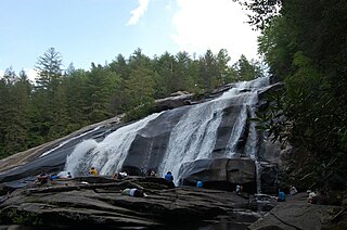
DuPont State Recreational Forest, commonly known as DuPont Forest, is a 12,500-acre (5,100 ha) state forest, located in Henderson and Transylvania counties of North Carolina. The name originates from the fact that the DuPont company arranged the sale of the original tract to the state. Adjacent tracts have since been purchased and added to the state forest. Portions of the forest formerly contained a manufacturing facility for the production of X-ray film. The forest was used to shoot scenes from the 1992 film The Last of the Mohicans as well as the 2012 box office hit The Hunger Games. On February 12, 2019, the forest added 402 acres (163 ha) from Conserving Carolina, part of a section called the Continental Divide Tract that connects with other public lands. 314 acres (127 ha) was added to the forest in 2019.

Turkey Swamp Park is a 2,388-acre (966 ha) county park and nature preserve in Freehold Township, New Jersey. Within the northernmost fringes of the Pine Barrens, the Turkey Swamp area is located on a ridge, being a major drainage divide within Central New Jersey. It includes the headwaters of the Manasquan that flows into Manasquan Inlet, and the Metedeconk and Toms River systems that flow into Barnegat Bay, to the east; the Manalapan Brook system that is part of the Raritan River basin, to the north; and the Assunpink and Crosswicks systems that flow into the Delaware River, and the Millstone River system that also flows to the Raritan, to the west. The chief recreational attraction of this park is the 17-acre (6.9 ha) lake suitable for bass, bluegill and catfish fishing, as well as canoeing and paddle boating.

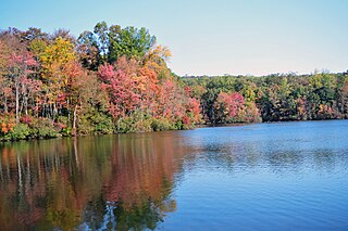
Keystone State Park is a 1,200-acre (486 ha) Pennsylvania state park in Derry Township, Westmoreland County, Pennsylvania in the United States. Located off U.S. Route 22 near New Alexandria, the park opened in 1945. Its main attraction is the man-made 78-acre (32 ha) Keystone Lake. The park also has extensive picnic areas and several miles of hiking trails.

White Clay Creek Preserve is a 3,050-acre (1,230 ha) Pennsylvania state park along the valley of White Clay Creek in London Britain Township in Chester County, Pennsylvania in the United States. The park was donated by the DuPont Company in 1984 for the purpose of "preserving the diverse and unique plant and animal species, and the rich cultural heritage of the area". Dupont also donated an additional 528 acres (214 ha) for the adjoining White Clay Creek State Park to the state of Delaware. White Clay Creek Preserve is 3 miles (4.8 km) north of Newark, Delaware on Pennsylvania Route 896.

Simon B. Elliott State Park is a 318-acre (129 ha) Pennsylvania state park located in Pine Township, Clearfield County, Pennsylvania in the United States. The park is surrounded by Moshannon State Forest. The park is entirely wooded with second growth forests of mixed oak species, including northern red oak, chestnut oak, shagbark hickory, red maple, and tulip poplar, and northern hard woods, including sugar maple, black cherry, aspen, birch, hemlock, and ash. S. B. Elliott State park is 9 miles (14 km) north of Clearfield on Pennsylvania Route 153 just off exit 111 of Interstate 80.

Lake Lurleen State Park is a publicly owned recreation area located on U.S. Highway 82 approximately 9 miles (14 km) northwest of Northport in Tuscaloosa County, Alabama. The state park's 1,625 acres (658 ha) include 250-acre (100 ha) Lake Lurleen and a 23-mile (37 km) trail system. It is operated by the Alabama Department of Conservation and Natural Resources.

Monmouth Council, BSA, established in 1917, serves all of Monmouth County, New Jersey and part of Middlesex County, New Jersey. The Council was the starting point for the landmark US Supreme Court case Boy Scouts of America v. Dale.
The Athens Conservancy is a 501 (c) (3) land trust based in Athens County, Ohio. It was founded in 2002. It is an all-volunteer organization.
Mayo River State Park is a North Carolina state park in Rockingham County, North Carolina in the United States. It covers 2,778-acre (11.24 km2) along the Mayo River, and it adjoins a Virginia State Park of the same name. North Carolina's park is near Mayodan, North Carolina. The park is one of the newest in the North Carolina system, having been authorized by the General Assembly in May 2003.

Rangeley Lake State Park is a public recreation area occupying 870 acres (350 ha) on the southern shore of Rangeley Lake in Franklin County, Maine. The state park is located partly in the town of Rangeley and partly in Rangeley Plantation. It is managed by the Maine Department of Agriculture, Conservation and Forestry.

Upton State Forest is a publicly owned forest with recreational features primarily located in the town of Upton, Massachusetts, with smaller sections in the towns of Hopkinton and Westborough. The state forest encompasses nearly 2,800 acres (1,100 ha) of publicly accessible lands and includes the last remaining Civilian Conservation Corps (CCC) camp in Massachusetts, built in Rustic style. The CCC campground was listed on the National Register of Historic Places in 2014.

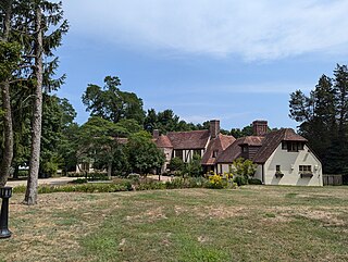
Tatum Park is a public park located at 351 Red Hill Road in Middletown Township, New Jersey. The 366-acre (1.48 km2) park is operated by the Monmouth County Park System. The park was formerly an estate, originally purchased by Charles Tatum in 1905, a New York-based glass manufacturer and entrepreneur. The property was used as a summer residence for the entrepreneur's family.
Huber Woods Park is a county park located in the community of Locust, Middletown Township, New Jersey. The 390-acre (160 ha) park, run by the Monmouth County Park System is situated in the Navesink Highlands and is primarily made up of preserved woodland and farmlands formerly owned by the Huber family. The park is often used for hiking, birdwatching and horseback riding and features an environmental center, housed in the former Huber family residence, a reptile house, and an equestrian area.


