Fuencaliente | |
|---|---|
Municipality | |
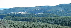 Panoramic view of Fuencaliente town | |
 Coat of arms | |
 Fuencaliente Location in Spain | |
| Coordinates: 38°24′19″N4°18′19″W / 38.40528°N 4.30528°W | |
| Country | |
| Autonomous community | |
| Province | Ciudad Real |
| Comarca | Fuencaliente-Sierra Madrona |
| Area | |
• Total | 269.85 km2 (104.19 sq mi) |
| Elevation | 700 m (2,300 ft) |
| Population (2024-01-01) [1] | |
• Total | 1,001 |
| • Density | 3.709/km2 (9.607/sq mi) |
| Demonym | Cucón/Cucona |
| Time zone | UTC+1 (CET) |
| • Summer (DST) | UTC+2 (CEST) |
| Postal code | 13130 |

Fuencaliente is a municipality located in Ciudad Real Province, Castile-La Mancha, Spain. According to the 2012 census, the municipality has a population of 1111 inhabitants. The village of Ventillas is part of its municipal term. [2]