
Cádiz is a province of southern Spain, in the southwestern part of the autonomous community of Andalusia. It is the southernmost part of mainland Spain, as well as the southernmost part of continental Europe.

Salinas is a town and municipality in the southern part of Puerto Rico located in the southern coast of the island, south of Aibonito and Cayey; southeast of Coamo, east of Santa Isabel; and west of Guayama. Salinas is spread over 5 barrios and Salinas Pueblo.

Peñuelas is a town and municipality in Puerto Rico located in the Peñuelas Valley on the southern coast of the island, south of Adjuntas, east of Guayanilla, west of Ponce and north of the Caribbean Sea. Peñuelas is spread over 12 barrios and Peñuelas Pueblo. It is part of the Yauco Metropolitan Statistical Area. Peñuelas is known as "La Capital del Güiro" and "El Valle de los Flamboyanes". In 2020, Peñuelas had a population of 20,399.

Lugo is a city in northwestern Spain in the autonomous community of Galicia. It is the capital of the province of Lugo. The municipality had a population of 98,025 in 2018, making it the fourth most populous city in Galicia.

Ciales is a town and municipality of Puerto Rico, located on the Central Mountain Range, northwest of Orocovis; south of Florida and Manatí; east of Utuado and Jayuya; and west of Morovis. Ciales is spread over eight barrios and Ciales Pueblo. It is part of the San Juan-Caguas-Guaynabo Metropolitan Statistical Area.

Guánica is a town and municipality in southern Puerto Rico, bordering the Caribbean Sea, south of Sabana Grande, east of Lajas, and west of Yauco. It is part of the Yauco metropolitan statistical area.

Las Marías is a town and municipality of Puerto Rico located north of Maricao; southeast of Añasco; south of San Sebastián; east of Mayagüez; and west of Lares. Las Marías is spread over 13 barrios and Las Marías Pueblo.

Maricao is a town and the second-least populous municipality of Puerto Rico; it is located at the western edge of the Cordillera Central. It is a small town set around a small square in hilly terrain, north of San Germán, Sabana Grande and Yauco; south of Las Marías and Lares, southeast of Mayagüez, and west of Adjuntas. Maricao is spread over 6 barrios and Maricao Pueblo.

Naguabo is a town and municipality in Puerto Rico located in the east coast of the island bordered by the Vieques Passage, north of Humacao; south of Río Grande and Ceiba; and east of Las Piedras. Naguabo is spread over 8 barrios and Naguabo Pueblo. It is part of the San Juan-Caguas-Guaynabo Metropolitan Statistical Area.

Santiago Rodríguez is a province in the northwest region of the Dominican Republic. It was split from Monte Cristi in 1948. The Santiago Rodríguez province has the Monte Cristi and Valverde provinces to the north, the Santiago province to the east, the San Juan and Elías Piña provinces to the south and the Dajabón province to the west.

Orani, officially the Municipality of Orani, is a 1st class municipality in the province of Bataan, Philippines. According to the 2020 census, it has a population of 70,342 people.

Boimorto is a municipality in the province of A Coruña, in the autonomous community of Galicia, northwestern Spain. It is located in the comarca of Arzúa. It has an area of 82.71 km2, a population of 2,486, and a population density of 30.06 people/km2. Coordinates: 43° 00' 27" N - 8° 07' 37" W. Elevation: 487 m.

Castellar de la Frontera is a town and municipality located in the province of Cádiz, in Andalusia, Spain. It is a medieval town within a castle.

Santa Coloma de Gramenet, informally simply known as Santa Coloma, and formerly as Gramenet de Besòs between 1936 and 1939, is a municipality in Barcelonès county, in Catalonia, Spain. It is situated on the south-east side of the coastal range, with the Puig Castellar (299 m) as its highest point, on the left bank of the Besòs river: the municipalities of Sant Adrià de Besòs and Badalona separate it from the coast. It is the ninth most populated city in Catalonia.
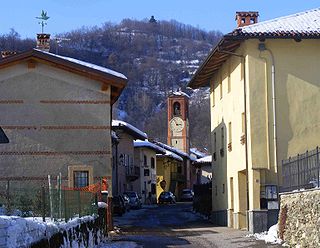
Castellar was a comune (municipality) in the Province of Cuneo in the Italian region Piedmont, located about 50 kilometres (31 mi) southwest of Turin and about 30 kilometres (19 mi) northwest of Cuneo. As of 31 December 2004, it had a population of 253 and an area of 3.8 square kilometres (1.5 sq mi).

Castellar del Vallès is a Spanish municipality of Catalonia in the comarca of Vallès Occidental. It is located 7 km from Sabadell and 11 km from Terrassa, the comarca's two capitals. Other villages near Castellar del Vallès are Sant Llorenç Savall, Matadepera and Sentmenat.

Torres de Berrellén is a municipality located in the province of Zaragoza, Aragon, Spain. According to the 2004 census (INE), the municipality has a population of 1450 inhabitants. Its population density is 28,08 inhabitants per square kilometre.
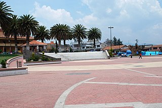
Temoaya is a municipality in the State of Mexico, Mexico. It's municipal seat is the town of Temoaya which is the sixth largest town in the municipality. It is located 18 kilometres (11 mi) from Toluca and 85 kilometres (53 mi) from Mexico City. It is known for its large ethnic Otomi population, the Centro Ceremonial Otomí and its tradition of making Persian style rugs using Mexican designs.

Castellar del Riu is a municipality in the comarca of Berguedà, Catalonia, northern Spain. The municipal government is located at Llinars, which is not a village but just a few municipal buildings including a small sports centre.

Grañón is a village in the province and autonomous community of La Rioja, Spain. The municipality covers an area of 31.01 square kilometres (11.97 sq mi) and as of 2011 had a population of 307 people. It belongs to the comarca of Santo Domingo de la Calzada and the judicial district of Haro. Its residents, known as Grañoneros or Grañoneras, work primarily in agriculture and the cattle industry, with many young people being forced to leave the village to look for other forms of work in Logroño, the capital of La Rioja.


