
Adelaide Metro is the public transport system of Adelaide, the capital city of South Australia. It is an intermodal system offering an integrated network of bus, tram, and train services throughout the metropolitan area. The network has an annual patronage of 79.9 million, of which 51 million journeys are by bus, 15.6 million by train, and 9.4 million by tram. The system has evolved heavily over the past fifteen years, and patronage increased dramatically during the 2014–15 period, a 5.5 percent increase on the 2013 figures due to electrification of frequented lines.

The rail network in Adelaide, South Australia, consists of four lines and 89 stations, totalling 132 km (82 mi). It is operated by Keolis Downer under contract from the Government of South Australia, and is part of the citywide Adelaide Metro public transport system.
The Division of Bonython was an Australian Electoral Division in South Australia between 1955 and 2004. In its final configuration, it was based on the outer northern suburbs of Elizabeth, Munno Para, Parafield, Paralowie, Salisbury, Virginia, and to the town of One Tree Hill in Adelaide's outskirts. Bonython's first 14 years saw vast boundaries simultaneously cover as far north as Gawler, as far south as Magill Road at Norwood, and as far west as Ottoway. The seat would continue to cross south of Grand Junction Road until the creation of the Division of Makin at the pre-1984 redistribution.

Mawson Lakes is a residential suburb in the City of Salisbury, Adelaide, Australia. Named in honor of Sir Douglas Mawson, it has a census area population of 10,872 people. The suburb is located in the northern suburbs of Adelaide around 12 km north of the Central business district. Much of the suburb was previously known as The Levels, and was a non-residential area, housing a campus of the University of South Australia and Technology Park Adelaide.

The Gawler line, also known as the Gawler Central line, is a suburban commuter railway line in the city of Adelaide, South Australia. The Gawler Line is the most frequent and heavily patronised line in the Adelaide rail network.
Regency Park is an inner-northern suburb of Adelaide, 6 km from the City Centre, in the state of South Australia, Australia. It is located in the City of Port Adelaide Enfield, and is adjacent to Wingfield, Angle Park, Ferryden Park, Kilburn, Prospect, Dudley Park and Croydon Park. It is bounded to the north by Grand Junction Road, east by the Gawler railway line, south by Regency Road and to the west by Days and South Roads. The postcode for Regency Park is 5010.

Dudley Park railway station is located on the Gawler line. Situated in the inner northern Adelaide suburb of Dudley Park, it is located 4.9 kilometres (3.0 mi) from Adelaide station.

Islington railway station is located on the Gawler line. Situated in the inner northern Adelaide suburb of Prospect adjacent to Regency Road, it is 6 kilometres (3.7 mi) from the Adelaide station.

Kilburn railway station is located on the Gawler line. The station is situated in the inner northern Adelaide suburb of Kilburn, it is 7.7 kilometres (4.8 mi) from Adelaide station.

Greenfields railway station is located on the Gawler line. Situated adjacent to Parafield Airport, in the northern Adelaide suburb of Parafield, it is 15.5 kilometres (9.6 mi) from Adelaide station.

Nurlutta railway station is located on the Gawler line. Situated in the northern Adelaide suburb of Salisbury, it is 21.5 kilometres (13.4 mi) from Adelaide station.

Elizabeth railway station is located on the Gawler line. Situated on the border of the northern Adelaide suburbs of Elizabeth and Edinburgh, it is 25.8 kilometres (16.0 mi) from Adelaide station.
Evanston railway station is located on the Gawler line. Situated in the northern Adelaide suburb of Evanston, it is 38.3 kilometres (23.8 mi) from Adelaide station.
Bowmans is a locality in South Australia's Mid North. At the 2006 census, Bowmans had a population of 203. It is named after R and C Bowman who were "pastoralists in area."

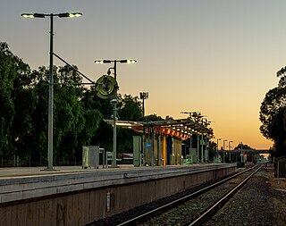
Salisbury railway station is a railway station and bus interchange in the northern Adelaide suburb of Salisbury. It is on the Gawler line, 20.2 kilometres (12.6 mi) from Adelaide station. Adjoining it is a large park & ride carpark, making it one of the busiest stations on the Adelaide suburban rail system.

Renown Park is an inner northern suburb of Adelaide, South Australia. It is located in the City of Charles Sturt.

Salisbury is a northern suburb in Adelaide, South Australia. It is the seat of the City of Salisbury, and in the South Australian Legislative Assembly electoral district of Ramsay and the Australian House of Representatives division of Spence. The suburb is a service area for the City of Salisbury district, with an abundance of parklands, shops, cafes and restaurants. Parabanks Shopping Centre is also located in Salisbury, which includes Woolworths, Coles and Big W as its signature retailers.

Green Fields is a suburb of Adelaide, the capital of South Australia. It is around 13 km north of the city centre, and mostly consists of industrial warehouses and light industry.
Salisbury Downs is a suburb located in the City of Salisbury, Adelaide, South Australia. The suburb is bordered by Kings Road, the Little Para River, Burton Road, Spains Road and the Gawler railway line.